


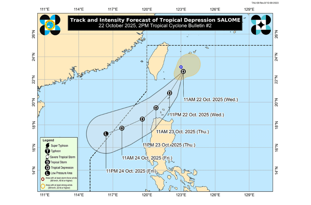
Tropical Depression #SalomePH maintained its strength while remaining almost stationary north of Batanes as of 1 p.m. on Wednesday, October 22, 2025, according to PAGASA.
At 1 p.m., Salome was spotted about 255 kilometers north-northeast of Itbayat, Batanes, with maximum sustained winds of 55 kilometers per hour (kph) near the center and gusts reaching 70 kph.
Salome is expected to move southwest and may pass close to or make landfall over Batanes tonight or early Thursday morning.
It could also pass near the Babuyan Islands by Thursday morning and Ilocos Norte by Thursday afternoon.
The system may exit the Philippine Area of Responsibility (PAR) by Friday evening.
While Salome is likely to stay a tropical depression, PAGASA said slight strengthening into a tropical storm is still possible before it weakens into a low-pressure area by the end of the week.
Areas under Tropical Cyclone Wind Signal No. 1 (strong winds, 39–61 km/h)
- Batanes
- Western portion of Babuyan Islands (Calayan Is., Dalupiri Is.)
- Northwestern portion of Ilocos Norte (Bangui, Pagudpud, Burgos, Pasuquin, Bacarra, Laoag City)
PAGASA said the highest wind signal expected during Salome’s passage is Signal No. 1, but it may intensify into a tropical storm, which could raise the warning to Signal No. 2.
Even areas outside the storm’s direct path may still feel its effects due to strong northeasterly winds. Gusty conditions are expected over:
- October 22: Ilocos Norte, Ilocos Sur, and Cagayan
- October 23: Batanes, Babuyan Islands, Cagayan, Ilocos Norte, and Ilocos Sur
- October 24: Batanes, Babuyan Islands, Cagayan, and Ilocos Norte
According to PAGASA’s earlier advisory, Salome may bring 50 to 100 millimeters of rain over Batanes until tomorrow noon (October 23). Rainfall may be heavier in mountainous areas, and impacts could worsen due to previous rains.
PAGASA has also issued a Gale Warning over the northern seaboard of Luzon. Sea travel is risky for all types of vessels due to rough to very rough seas in the following areas:
- Up to 4.5 meters: Batanes
- Up to 4.0 meters: Babuyan Islands and Ilocos Norte
- Up to 3.5 meters: Ilocos Sur
- Up to 3.0 meters: Northern Cagayan and western Pangasinan
Smaller boats and motorbancas are advised not to venture out to sea as waves may reach dangerous heights.
