


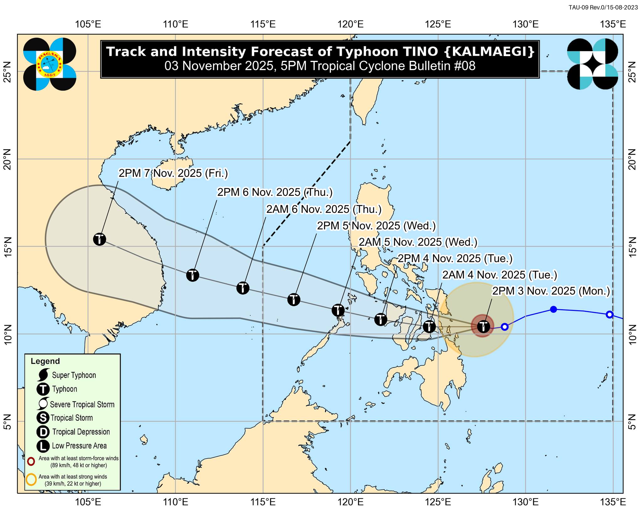
Typhoon Tino intensifies slightly as it moves toward the Eastern Visayas-Caraga area, according to PAGASA's weather bulletin issued at 5 p.m. on Monday, November 3, 2025.
Location of Center (4 p.m.):
The center of #TinoPH was estimated based on all available data including those from Guiuan Doppler Weather Radar at 170 km East Southeast of Guiuan, Eastern Samar (10.5°N, 127.2°E).
Intensity:
Maximum sustained winds of 130 km/h near the center, gustiness of up to 160 km/h, and central pressure of 970 hPa
Present Movement:
Westward at 20 km/h
Extent of Tropical Cyclone Winds:
Strong to typhoon-force winds extend outwards up to 300 km from the center
TROPICAL CYCLONE WIND SIGNALS (TCWS) IN EFFECT
TCWS No. 4
* Wind threat: Typhoon-force winds
* Warning lead time: 12 hours
* Range of wind speeds: 118 to 184 km/h (Beaufort 12)
* Potential impacts of winds: Significant to severe threat to life and property
VISAYAS:
The extreme southeastern portion of Eastern Samar (Guiuan), the southern portion of Leyte (Mahaplag, Abuyog, City of Baybay, Inopacan, Hilongos, Hindang, Bato, Matalom, Javier), Southern Leyte, Camotes Islands, and the northeastern portion of Bohol (Pres. Carlos P. Garcia, Getafe, Trinidad, Ubay, Bien Unido, Talibon)
MINDANAO:
Dinagat Islands, and Siargao and Bucas Grande Islands
TCWS No. 3
* Wind threat: Storm-force winds
* Warning lead time: 18 hours
* Range of wind speeds: 89 to 117 km/h (Beaufort 10 to 11)
* Potential impacts of winds: Moderate to significant threat to life and property
VISAYAS:
The southern portion of Eastern Samar (Mercedes, Lawaan, Balangiga, Giporlos, Quinapondan, Salcedo), the southern portion of Samar (Marabut), the central portion of Leyte (Tanauan, Palo, Tabontabon, Isabel, Merida, Palompon, Ormoc City, Dagami, Pastrana, Burauen, Albuera, Macarthur, La Paz, Mayorga, Dulag, Julita, Tolosa, Matag-Ob, Villaba, Kananga, Jaro), the northern and central portions of Cebu (Borbon, Sogod, Catmon, Carmen, Danao City, Compostela, Liloan, Lapu-Lapu City, Cordova, Consolacion, Mandaue City, Cebu City, Asturias, Balamban, Tuburan, Tabuelan, Tabogon, City of Talisay, City of Bogo, San Remigio, Medellin, Daanbantayan, Sibonga, City of Carcar, San Fernando, City of Naga, Minglanilla, Toledo City, Aloguinsan, Pinamungahan, Barili, Dumanjug) including Bantayan Islands, and the central and eastern portions of Bohol (San Miguel, Mabini, Buenavista, Inabanga, Danao, Dagohoy, Guindulman, Pilar, Alicia, Candijay, Anda, Jagna, Duero, Sierra Bullones, Carmen, Sagbayan, Clarin, Tubigon), the northern portion of Negros Oriental (Vallehermoso, Canlaon City, City of Guihulngan), the northern portion of Negros Occidental (Hinigaran, Moises Padilla, Isabela, La Castellana, Pontevedra, San Enrique, La Carlota City, Cadiz City, Bago City, Enrique B. Magalona, Toboso, Valladolid, Salvador Benedicto, Sagay City, Bacolod City, Murcia, City of Escalante, Calatrava, San Carlos City, Silay City, Pulupandan, City of Victorias, City of Talisay, Manapla), Guimaras, and the eastern portion of Iloilo (Concepcion, Barotac Nuevo, Ajuy, Iloilo City, Anilao, Barotac Viejo, Leganes, Zarraga, Dumangas, Banate)
MINDANAO:
The rest of Surigao del Norte
TCWS No. 2
* Wind threat: Gale-force winds s
*Warning lead time: 24 hours
* Range of wind speeds: 62 to 88 km/h (Beaufort 8 to 9)
* Potential impacts of winds: Minor to moderate threat to life and property
LUZON:
The southern portion of Masbate (Esperanza, Pio V. Corpuz, Placer, Balud, Cawayan), the southern portion of Romblon (San Jose, Santa Fe, Alcantara, Looc), and Cuyo Islands
VISAYAS:
The central portion of Eastern Samar (Can-Avid, City of Borongan, Taft, Llorente, Maydolong, Balangkayan, Sulat, San Julian, General Macarthur, Hernani), the central portion of Samar (San Sebastian, Santa Rita, Villareal, Zumarraga, Pinabacdao, Talalora, Jiabong, City of Catbalogan, Motiong, Calbiga, Daram, Paranas, Basey, Hinabangan, Santo Niño, Almagro, Tarangnan), the rest of Leyte, Biliran, the rest of Bohol, the rest of Cebu, and central portion of Negros Oriental (Tayasan, Manjuyod, City of Tanjay, Bais City, Mabinay, Bindoy, Ayungon, Jimalalud, La Libertad, Sibulan, San Jose, Amlan, Pamplona, City of Bayawan, Basay, Valencia, Dumaguete City, Bacong), the rest of Negros Occidental, Siquijor, Capiz, the rest of Iloilo, Aklan, and Antique
MINDANAO:
The northern portion of Surigao del Sur (Carrascal, Cantilan, Madrid, Carmen, Lanuza, Cortes, Tago, San Miguel, Marihatag, Cagwait, Bayabas, City of Tandag), the northern portion of Agusan del Sur (Sibagat), the northern portion of Agusan del Norte (Kitcharao, Jabonga, Santiago, Tubay, City of Cabadbaran, Remedios T. Romualdez, Magallanes), and Camiguin
TCWS No. 1
* Wind threat: Strong winds
* Warning lead time: 36 hours
* Range of wind speeds: 39 to 61 km/h (Beaufort 6 to 7)
* Potential impacts of winds: Minimal to minor threat to life and property
LUZON:
Albay, Sorsogon, the rest of Masbate including Ticao and Burias Islands, the southern portion of Quezon (San Francisco, San Andres), the southern portion of Marinduque (Torrijos, Buenavista, Gasan, Boac), the rest of Romblon, Oriental Mindoro, Occidental Mindoro, and the northern and central portions of Palawan (El Nido, Taytay, Dumaran, Araceli, San Vicente, Roxas, Puerto Princesa City, Aborlan) including Calamian Islands and Cagayancillo Islands
VISAYAS:
Northern Samar, the rest of Eastern Samar, the rest of Samar, and the rest of Negros Oriental
MINDANAO:
The rest of Surigao del Sur, the central portion of Agusan del Sur (City of Bayugan, Prosperidad, Esperanza, San Luis, Talacogon, San Francisco, Rosario), the rest of Agusan del Norte, Misamis Oriental, and the northern portion of Bukidnon (Baungon, Malitbog, Impasug-Ong, Libona, Manolo Fortich, Sumilao), the northern portion of Misamis Occidental (Baliangao, Plaridel, Sapang Dalaga, Calamba, Lopez Jaena, Concepcion, Oroquieta City, Aloran), and the northern portion of Zamboanga del Norte (Sibutad, Rizal, Dipolog City, Manukan, Pres. Manuel A. Roxas, Katipunan, Polanco, Dapitan City, Piñan, La Libertad, Mutia, Jose Dalman)
(Courtesy: DOST-PAGASA)
