


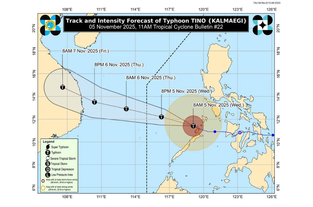
Typhoon #TinoPH strengthened slightly morning on Wednesday, November 5, 2025, as it moved farther away from northern Palawan toward the West Philippine Sea, according to PAGASA.
At 10 a.m., the center of Tino’s eye was located about 190 kilometers west of Coron, Palawan. The typhoon packed maximum sustained winds of 130 kilometers per hour near the center, gusts of up to 180 km/h, and was moving west northwest at 20 km/h.
PAGASA said strong to typhoon-force winds extend up to 300 kilometers from the center.
Tino is expected to continue moving west-northwest and may exit the Philippine Area of Responsibility (PAR) tonight or early Thursday. The typhoon could further intensify while over the West Philippine Sea before weakening outside PAR.
Areas under Tropical Cyclone Wind Signals:
Areas under Wind Signal No. 4 (typhoon-force winds, 118–184 km/h)
- The northernmost portion of Palawan (El Nido)
Areas under Wind Signal No. 3 (storm-force winds, 89–117 km/h)
- The northern portion of Palawan (San Vicente, Taytay) including Calamian Islands
Areas under Wind Signal No. 2 (gale-force winds, 62–88 km/h)
- The eastern and central portions of Palawan (Puerto Princesa City, Roxas, Dumaran, Araceli) including Kalayaan Islands
Areas under Wind Signal No. 1 (strong winds, 39–61 km/h)
- Occidental Mindoro including Lubang Islands
- Southern portion of Oriental Mindoro (Bongabong, Roxas, Bulalacao, Mansalay)
- Southern portion of Palawan (Aborlan, Quezon, Narra, Sofronio Española) including Cuyo Islands
PAGASA raised a storm surge warning for coastal communities in Palawan, where water levels could rise over three meters and may pose life-threatening risks and flooding in low-lying areas.
Sea conditions remain dangerous, with waves reaching up to six meters off northern Palawan and 4.5 meters around Calamian and Kalayaan Islands. Sea travel is not advised for any type of vessel in affected areas.
