


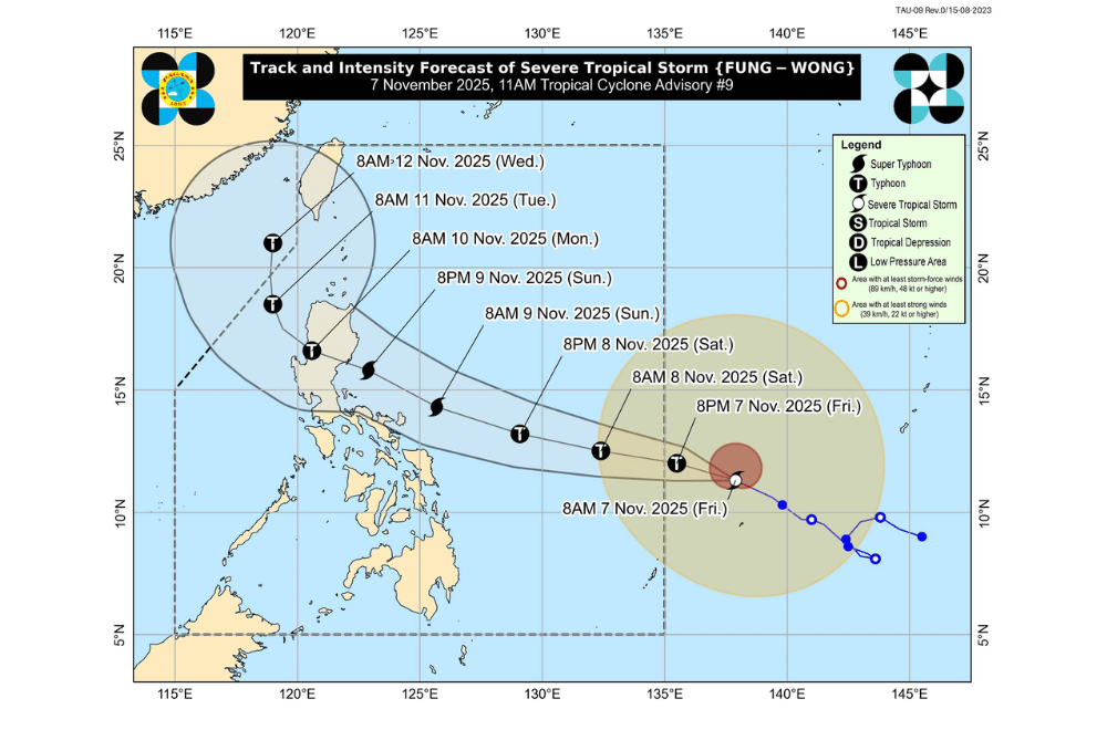
Tropical Storm Fung-Wong continued to gain strength over the Philippine Sea northeast of Palau on Friday, November 7, 2025, and is expected to enter the Philippine Area of Responsibility (PAR) by late Friday night or early Saturday, according to PAGASA.
Once inside the PAR, it will be named Uwan.
At 10 a.m., Fung-Wong was located 1,315 kilometers east of Eastern Visayas, packing maximum sustained winds of 100 kilometers per hour and gusts of up to 125 km/h. It was moving west-northwest at 20 km/h.
PAGASA said Fung-Wong could intensify rapidly, reaching typhoon category within 24 hours and possibly super typhoon strength by Saturday night or Sunday morning.
The storm may make landfall over southern Isabela or northern Aurora late Sunday or early Monday before crossing Northern Luzon and exiting toward the West Philippine Sea on Monday afternoon.
Residents in Southern Luzon, Eastern Visayas, and Caraga were advised to prepare, as wind signals may be raised as early as Friday afternoon or evening. PAGASA said the highest possible alert level for this storm is Signal No. 5.
By Sunday, weather is expected to worsen in many parts of Northern and Central Luzon, bringing heavy rain, strong winds, and possible flooding or landslides. PAGASA also warned of storm surges and coastal flooding, especially along the eastern coasts of Luzon and Visayas.
Seas will begin to turn rough to very rough along the eastern coasts of Luzon, Visayas, and Mindanao starting Friday or Saturday, making sea travel risky for all types of vessels. Gale warnings may be issued by Saturday.
PAGASA advised the public and local disaster offices to closely monitor updates and prepare for possible evacuation if necessary.
