


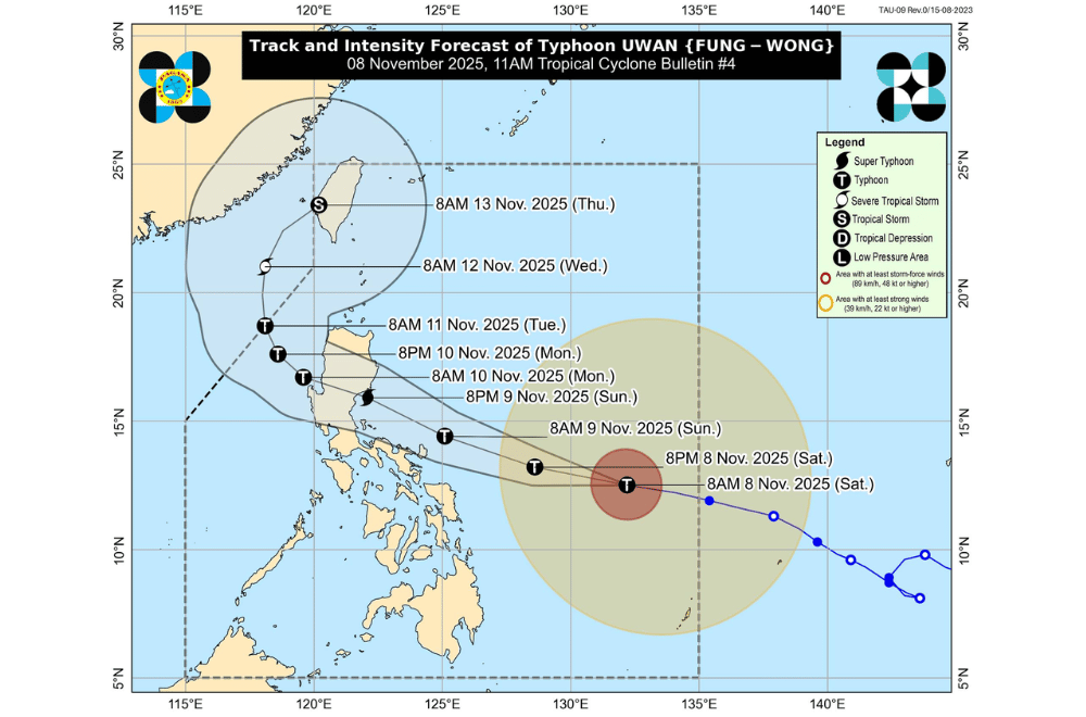
Typhoon #UwanPH (international name Fung-Wong) has rapidly strengthened over the Philippine Sea and is now moving closer to Eastern Visayas and Bicol, according to PAGASA’s 11 a.m. bulletin on Saturday, November 8, 2025.
At 10 a.m., Uwan was located 680 kilometers east of Borongan City, Eastern Samar, packing maximum sustained winds of 140 kilometers per hour and gusts reaching 170 km/h.
It was moving westward at 35 km/h. PAGASA said Uwan could still intensify into a super typhoon by evening on Saturday or Sunday as it moves toward Luzon.
PAGASA said Uwan will likely move west-northwestward, possibly passing close to Catanduanes by Sunday morning before making landfall over southern Isabela or northern Aurora late Sunday or early Monday.
There is still a chance the storm could shift slightly southward and directly hit Catanduanes.
After crossing Northern Luzon, Uwan is expected to move out toward the Lingayen Gulf or the West Philippine Sea by Monday afternoon.
AREAS UNDER TROPICAL CYCLONE WIND SIGNALS
Areas under Wind Signal No. 2 (gale-force winds, 62–88 km/h):
- Catanduanes
- Eastern portion of Camarines Sur (Siruma, Tinambac, Goa, Lagonoy, Buhi, Caramoan, Tigaon, Garchitorena, Calabanga, Sagñay, San Jose, Presentacion, Baao, Ocampo, Milaor, Nabua, Bato, Camaligan, Pili, Iriga City, Magarao, Minalabac, Balatan, Naga City, Bombon, Bula, Canaman)
- Albay
- Sorsogon
- Ticao Islands
- Northern Samar
- Northern portion of Samar (Matuguinao, San Jose de Buan, Calbayog City)
- Northern portion of Eastern Samar (Maslog, San Policarpo, Dolores, Jipapad, Oras, Arteche)
Areas under Wind Signal No. 1 (strong winds, 39–61 km/h)
- Batanes
- Cagayan
- Isabela
- Quirino
- Nueva Vizcaya
- Apayao
- Abra
- Kalinga
- Mountain Province
- Ifugao
- Benguet
- Ilocos Norte
- Ilocos Sur
- La Union
- Pangasinan
- Aurora
- Nueva Ecija
- Bulacan
- Tarlac
- Pampanga
- Zambales
- Bataan
- Metro Manila
- Cavite
- Laguna
- Batangas
- Rizal
- Quezon
- Camarines Norte
- The rest of Camarines Sur
- The rest of Masbate including Burias Island
- Marinduque
- Romblon
- Oriental Mindoro
- Occidental Mindoro including Lubang Islands
- Calamian Islands
- Cuyo Islands
- The rest of Samar
- The rest of Eastern Samar
- Biliran, Leyte
- Southern Leyte
- Northeastern portion of Bohol (Getafe, Talibon, Buenavista, Trinidad, San Miguel, Ubay, Alicia, Mabini, Bien Unido, Pres. Carlos P. Garcia)
- Northern and central portions of Cebu (Medellin, Daanbantayan, City of Bogo, Tabogon, San Remigio, Tabuelan, Borbon, Sogod, Tuburan, Catmon, Carmen, Danao City, Compostela, Liloan, Consolacion, Lapu-Lapu City, Mandaue City, Cordova, Asturias, Cebu City, Balamban, City of Talisay, Toledo City, Minglanilla) including Bantayan and Camotes Islands
- Northern portion of Negros Occidental (City of Escalante, Toboso, Sagay City, Cadiz City, Calatrava, Manapla, City of Victorias, Enrique B. Magalona, Silay City, City of Talisay, San Carlos City, Salvador Benedicto, Murcia, Bacolod City)
- Northern and central portions of Iloilo (Carles, Estancia, Balasan, San Dionisio, Concepcion, Batad, Sara, Ajuy, Barotac Viejo, San Rafael, Lemery, Lambunao, Calinog, Bingawan, City of Passi, San Enrique, Anilao, Banate, Dingle, Dueñas, Janiuay, Badiangan, Mina, Pototan, Barotac Nuevo, Maasin, Cabatuan, New Lucena, Santa Barbara, Zarraga, Dumangas, Leon, Alimodian)
- Capiz
- Aklan
- Northern and central portions of Antique (Pandan, Libertad, Sebaste, Culasi, Valderrama, Tibiao, Barbaza, Laua-An, Bugasong, Patnongon, San Remigio) including Caluya Islands
- Dinagat Islands
- Surigao del Norte
Heavy rain, severe winds, and storm surges are expected even in areas far from the storm’s center. PAGASA warned of life-threatening storm surges higher than three meters along coastal areas of Luzon and Eastern Visayas, including Bicol, Quezon, Northern Samar, and Metro Manila.
Seas are also expected to become very rough to high, with waves reaching up to 14 meters in some areas.
PAGASA strongly advised fisherfolk and small boats not to venture out to sea.
Residents in flood-prone and coastal areas were urged to follow evacuation orders and local advisories as Uwan continues to intensify.
