


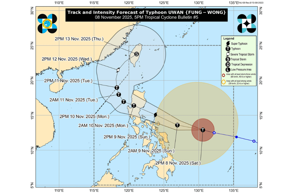
Typhoon #UwanPH (international name: Fung-wong) continued to strengthen afternoon on Saturday, November 8, 2025 as it moved closer toward the Bicol Region, according to PAGASA.
Uwan was last spotted 575 kilometers east of Catarman, Northern Samar, or 620 kilometers east of Virac, Catanduanes. It was moving west-northwest at 30 kilometers per hour, packing maximum sustained winds of 150 km/h near the center and gusts reaching 185 km/h.
Uwan is expected to move west-northwest until Sunday, passing close to Catanduanes by tomorrow morning and possibly making landfall over southern Isabela or northern Aurora by Sunday evening or early Monday.
PAGASA added there is an increasing chance the typhoon could slightly shift southward, which may bring the eyewall directly over Catanduanes.
The typhoon is forecast to intensify further into a super typhoon tonight or early Sunday before weakening as it crosses Northern Luzon’s mountains. It is expected to remain a typhoon when it emerges over the West Philippine Sea by Monday.
AREAS UNDER TROPICAL CYCLONE WIND SIGNALS
Areas under Wind Signal No. 3 (storm-force winds, 89–117 km/h) (Warning lead time: 18 hours):
- Catanduanes
- Eastern portion of Camarines Sur (Siruma, Tinambac, Goa, Lagonoy, Caramoan, Tigaon, Garchitorena, Sagñay, San Jose, Presentacion)
- Eastern portion of Albay (Tiwi, Santo Domingo, Malinao, Rapu-Rapu, City of Tabaco, Bacacay, Malilipot)
- Northeastern portion of Sorsogon (Prieto Diaz)
- Northeastern portion of Northern Samar (Palapag, Mapanas, Laoang)
Areas under Wind Signal No. 2 (gale-force winds, 62–88 km/h) (Warning lead time: 24 hours)
- Eastern portion of mainland Cagayan
- Isabela
- Quirino
- Nueva Vizcaya
- Aurora
- Nueva Ecija
- Bulacan
- Metro Manila
- Rizal
- Laguna
- Quezon
- Marinduque
- Camarines Norte
- The rest of Camarines Sur
- The rest of Albay
- The rest of Sorsogon
- Burias Island
- Ticao Island
- The rest of Northern Samar
- Northern portion of Samar (Matuguinao, San Jose de Buan, Calbayog City, Tagapul-An, Santo Niño, Almagro, San Jorge, San Sebastian, Jiabong, Pagsanghan, City of Catbalogan, Gandara, Motiong, Santa Margarita, Tarangnan, Paranas, Hinabangan)
- Northern portion of Eastern Samar (Maslog, San Policarpo, Dolores, Jipapad, Oras, Arteche, Can-Avid, City of Borongan, Taft, Sulat, San Julian, Maydolong)
Areas under Wind Signal No. 1 (strong winds, 39–61 km/h)
- Batanes
- The rest of Cagayan including Babuyan Islands
- Apayao
- Abra
- Kalinga
- Mountain Province
- Ifugao
- Benguet
- Ilocos Norte
- Ilocos Sur
- La Union
- Pangasinan
- Tarlac
- Pampanga
- Zambales
- Bataan
- Cavite
- Batangas
- The rest of Masbate
- Romblon
- Oriental Mindoro
- Occidental Mindoro including Lubang Islands
- Calamian Islands
- Cuyo Islands
- The rest of Samar
- The rest of Eastern Samar
- Biliran
- Leyte
- Southern Leyte
- Bohol
- The northern and central portions of Cebu (Medellin, Daanbantayan, City of Bogo, Tabogon, San Remigio, Tabuelan, Borbon, Sogod, Tuburan, Catmon, Carmen, Danao City, Compostela, Liloan, Consolacion, Lapu-Lapu City, Mandaue City, Cordova, Asturias, Cebu City, Balamban, City of Talisay, Toledo City, Minglanilla, Dumanjug, Argao, Sibonga, Barili, Ronda, Moalboal, Badian, Dalaguete, Alcantara, City of Carcar, City of Naga, San Fernando, Pinamungahan, Aloguinsan) including Bantayan and Camotes Islands
- The northern portion of Negros Occidental (City of Escalante, Toboso, Sagay City, Cadiz City, Calatrava, Manapla, City of Victorias, Enrique B. Magalona, Silay City, City of Talisay, San Carlos City, Salvador Benedicto, Murcia, Bacolod City, Hinigaran, City of Himamaylan, Binalbagan, Isabela, Moises Padilla, La Castellana, Pontevedra, San Enrique, La Carlota City, Bago City, Valladolid, Pulupandan)
- The northern portion of Negros Oriental (Canlaon City, Jimalalud, La Libertad, Tayasan, Vallehermoso, City of Guihulngan)
- Guimaras
- Iloilo
- Capiz
- Aklan
- Antique
- Dinagat Islands
- Surigao del Norte
- The northern portion of Agusan del Norte (Tubay, Santiago, Jabonga, Kitcharao)
- The northern portion of Surigao del Sur (Carrascal, Cantilan, Madrid, Carmen, Lanuza, Cortes)
A Gale Warning is in effect over the northern, eastern, and southern coasts of Luzon, eastern and central Visayas, and eastern Mindanao.
Waves may reach up to 14 meters high along the eastern coasts of Bicol, while seas off Isabela, Aurora, and Northern Samar could rise up to 12 meters. PAGASA strongly advised all vessels to stay in port or seek safe shelter as sea travel remains risky.
There is a high risk of life-threatening storm surges reaching over three meters along low-lying coastal areas in parts of Northern Luzon, Bicol, Eastern Visayas, and Metro Manila within the next 48 hours.
Residents and disaster officials in areas under wind signals were urged to take all precautionary measures, prepare for possible evacuation, and monitor updates from PAGASA and local authorities.
