


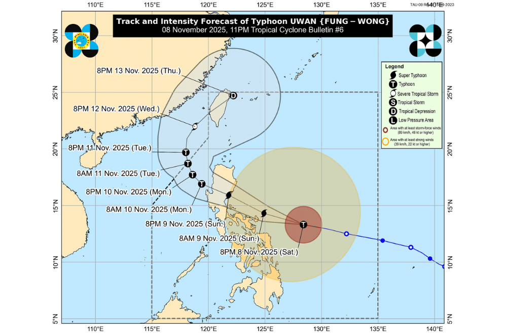
Typhoon #UwanPH (international name: Fung-Wong) continued to grow stronger late Saturday, November 8, as it moved closer to the Bicol Region with winds nearing super typhoon levels, according to PAGASA.
At 10 p.m., Uwan’s eye was located 380 kilometers east of Virac, Catanduanes, packing maximum sustained winds of 155 kilometers per hour and gusts reaching 190 km/h.
The typhoon was moving west-northwest at 35 km/h, with strong to typhoon-force winds extending as far as 800 kilometers from its center.
PAGASA said Uwan may pass close to Catanduanes on Sunday morning and could make landfall over Aurora by Sunday evening or early Monday.
There is also a chance it could slightly move southward, which may result in a direct hit over Catanduanes.
The typhoon is expected to reach super typhoon category within the next 24 hours before hitting land, though it will weaken once it crosses Northern Luzon’s mountains.
AREAS UNDER TROPICAL CYCLONE WIND SIGNALS
Areas under Wind Signal No. 4 (typhoon-force winds, 118–184 km/h) (Warning lead time: 12 hours)
- Catanduanes
Areas under Wind Signal No. 3 (storm-force winds, 89–117 km/h) (Warning lead time: 18 hours)
- Aurora
- Northern and eastern portions of Quezon (Pitogo, San Andres, Buenavista, San Francisco, Calauag, Infanta, Lopez, Catanauan, Mulanay, Guinayangan, Unisan, General Luna, Plaridel, Quezon, Alabat, Sampaloc, Macalelon, Mauban, General Nakar, Perez, Agdangan, Gumaca, Atimonan, Real, San Narciso, Tagkawayan) including Polillo Islands
- Camarines Norte
- Camarines Sur
- Albay
- Northern and eastern portions of Sorsogon (City of Sorsogon, Barcelona, Bulusan, Pilar, Castilla, Gubat, Casiguran, Donsol, Prieto Diaz)
- The eastern portion of Northern Samar (Palapag, Mapanas, Laoang, Gamay, Catubig, Pambujan, Biri)
Areas under Wind Signal No. 2 (gale-force winds, 62–88 km/h) (Warning lead time: 24 hours)
- Mainland Cagayan
- Isabela
- Quirino
- Nueva Vizcaya
- Apayao
- Abra
- Kalinga
- Mountain Province
- Ifugao
- Benguet
- Ilocos Norte
- Ilocos Sur
- La Union
- Pangasinan
- Nueva Ecija
- Bulacan
- Tarlac
- Pampanga
- Zambales
- Bataan
- Metro Manila
- Rizal
- Laguna
- The rest of Quezon
- Cavite
- Batangas
- Marinduque
- Northern portion of Oriental Mindoro (Puerto Galera, San Teodoro, Baco, City of Calapan, Naujan, Pola, Victoria)
- Northern portion of Romblon (Banton)
- The rest of Sorsogon
- Masbate including Ticao and Burias Islands
- The rest of Northern Samar
- Northern and central portions of Samar (Matuguinao, San Jose de Buan, Calbayog City, Tagapul-An, Santo Niño, Almagro, San Jorge, San Sebastian, Jiabong, Pagsanghan, City of Catbalogan, Gandara, Motiong, Santa Margarita, Tarangnan, Paranas, Hinabangan)
- Northern and central portions of Eastern Samar (Maslog, San Policarpo, Dolores, Jipapad, Oras, Arteche, Can-Avid, City of Borongan, Taft, Sulat, San Julian, Maydolong)
- Northern portion of Biliran (Maripipi)
Areas under Wind Signal No. 1 (strong winds, 39–61 km/h) (Warning lead time: 36 hours)
- Batanes
- Babuyan Islands
- The rest of Romblon
- The rest of Oriental Mindoro
- Occidental Mindoro
- Calamian Islands
- Cuyo Islands
- The rest of Samar
- The rest of Eastern Samar
- The rest of Biliran
- Leyte
- Southern Leyte
- Bohol
- Northern and central portions of Cebu (Medellin, Daanbantayan, City of Bogo, Tabogon, San Remigio, Tabuelan, Borbon, Sogod, Tuburan, Catmon, Carmen, Danao City, Compostela, Liloan, Consolacion, Lapu-Lapu City, Mandaue City, Cordova, Asturias, Cebu City, Balamban, City of Talisay, Toledo City, Minglanilla, Dumanjug, Argao, Sibonga, Barili, Ronda, Moalboal, Badian, Dalaguete, Alcantara, City of Carcar, City of Naga, San Fernando, Pinamungahan, Aloguinsan) including Bantayan and Camotes Islands
- Northern and central portions of Negros Occidental (City of Escalante, Toboso, Sagay City, Cadiz City, Calatrava, Manapla, City of Victorias, Enrique B. Magalona, Silay City, City of Talisay, San Carlos City, Salvador Benedicto, Murcia, Bacolod City, Hinigaran, City of Himamaylan, Binalbagan, Isabela, Moises Padilla, La Castellana, Pontevedra, San Enrique, La Carlota City, Bago City, Valladolid, Pulupandan)
- Northern portion of Negros Oriental (Canlaon City, Jimalalud, La Libertad, Tayasan, Vallehermoso, City of Guihulngan)
- Guimaras
- Iloilo
- Capiz
- Aklan
- Antique
- Dinagat Islands
- Surigao del Norte
- Northern portion of Agusan del Norte (Tubay, Santiago, Jabonga, Kitcharao)
- Northern portion of Surigao del Sur (Carrascal, Cantilan, Madrid, Carmen, Lanuza, Cortes)
Coastal communities along Catanduanes, Camarines provinces, Quezon, Bataan, Metro Manila, and nearby areas face a high risk of storm surge over three meters high.
Residents in low-lying and coastal areas are urged to evacuate early and heed local authorities’ advice.
Sea travel remains risky or dangerous across most seaboards of Luzon, Visayas, and Mindanao, with waves possibly reaching up to 14 meters high along the eastern coasts of Catanduanes, Camarines, and Aurora.
PAGASA urged the public and disaster management offices to take all precautions and follow evacuation orders from local officials. Heavy rain, severe winds, and storm surge may still affect areas far from the center of the typhoon.
