


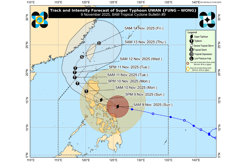
#UwanPH (international name: Fung-Wong) strengthened into a super typhoon morning on Saturday, November 9, 2025, bringing life-threatening winds, intense rain, and violent sea conditions to Catanduanes and nearby areas as it moved closer to Luzon, according to PAGASA.
At 8 a.m., PAGASA said the eye of Uwan was spotted 125 kilometers east-northeast of Virac, Catanduanes, carrying maximum sustained winds of 185 km/h and gusts reaching up to 230 km/h while moving west-northwest at 25 km/h.
The weather bureau warned that life-threatening conditions are now being experienced in Catanduanes, with extreme winds, heavy rainfall, and dangerous coastal flooding expected to worsen throughout the day.
According to PAGASA, Uwan may pass close to Catanduanes this morning before making landfall over Aurora tonight or early Sunday morning. A direct hit over Catanduanes remains possible if the typhoon’s path shifts slightly south.
The storm may make landfall at or near its peak strength, bringing widespread damage in areas directly in its path. It is forecast to cross Northern Luzon before emerging over Lingayen Gulf or the coastal waters of Pangasinan or La Union by Monday morning.
Even areas far from the landfall point may still experience heavy rains, destructive winds, and coastal flooding.
AREAS UNDER TROPICAL CYCLONE WIND SIGNALS
Areas under Wind Signal No. 5 (typhoon-force winds, 185 km/h or higher)
- Polillo Islands
- Northern portion of Camarines Norte (Daet, Talisay, Paracale, Vinzons, Jose Panganiban, Mercedes, Basud)
- Eastern portion of Camarines Sur (Siruma, Caramoan, Garchitorena, Tinambac, Lagonoy)
- Catanduanes
Areas under Wind Signal No. 4 (typhoon-force winds, 118–184 km/h)
- Eastern portion of Quezon (Tagkawayan, Calauag, Guinayangan, Perez, Alabat, Quezon)
- The rest of Camarines Norte
- The rest of Camarines Sur
- Eastern portion of Albay (Rapu-Rapu, Bacacay, City of Tabaco, Malilipot, Malinao, Tiwi, Polangui)
Areas under Wind Signal No. 3 (storm-force winds, 89–117 km/h)
- Southern portion of mainland Cagayan (Tuao, Enrile, Solana, Tuguegarao City, Peñablanca, Iguig, Piat, Amulung)
- Isabela
- Quirino
- Nueva Vizcaya
- Southern portion of Apayao (Conner)
- Kalinga
- Abra
- Mountain Province
- Ifugao
- Benguet
- Ilocos Sur
- La Union
- Pangasinan
- Zambales
- Bataan
- Tarlac
- Pampanga
- Nueva Ecija
- Bulacan
- Aurora
- Metro Manila
- Cavite
- Batangas
- Rizal
- Laguna
- The rest of Quezon
- Marinduque
- The rest of Albay
- Sorsogon
- Ticao and Burias Islands
- Northern Samar
- Northern portion of Eastern Samar (Jipapad, Arteche, San Policarpo, Oras, Dolores, Maslog)
- Northern portion of Samar (Calbayog City, Matuguinao, Gandara, Santa Margarita, San Jose de Buan)
Areas under Wind Signal No. 2 (gale-force winds, 62–88 km/h)
- The rest of Cagayan including Babuyan Islands
- The rest of Apayao
- Ilocos Norte
- Occidental Mindoro including Lubang Islands
- Oriental Mindoro
- Romblon
- The rest of Masbate
- The rest of Eastern Samar
- The rest of Samar
- Biliran
- Northern and central portions of Leyte (Leyte, Calubian, San Isidro, Tabango, Capoocan, Carigara, Barugo, San Miguel, Babatngon, Tacloban City, Alangalang, Tunga, Palo, Santa Fe, Pastrana, Matag-Ob, Tolosa, Mayorga, Julita, Dagami, Jaro, Villaba, La Paz, Tabontabon, Tanauan, Ormoc City, Dulag, Burauen, Kananga, Albuera, Palompon, Merida, Isabel)
Areas under Wind Signal No. 1 (strong winds, 39–61 km/h)
- Batanes
- Calamian Islands
- Cuyo Islands
- The rest of Leyte
- Southern Leyte
- Bohol
- Northern and central portions of Cebu (Medellin, Daanbantayan, City of Bogo, Tabogon, San Remigio, Tabuelan, Borbon, Sogod, Tuburan, Catmon, Carmen, Danao City, Compostela, Liloan, Consolacion, Lapu-Lapu City, Mandaue City, Cordova, Asturias, Cebu City, Balamban, City of Talisay, Toledo City, Minglanilla, Dumanjug, Argao, Sibonga, Barili, Ronda, Moalboal, Badian, Dalaguete, Alcantara, City of Carcar, City of Naga, San Fernando, Pinamungahan, Aloguinsan) including Bantayan and Camotes Islands
- Northern and central portions of Negros Occidental (City of Escalante, Toboso, Sagay City, Cadiz City, Calatrava, Manapla, City of Victorias, Enrique B. Magalona, Silay City, City of Talisay, San Carlos City, Salvador Benedicto, Murcia, Bacolod City, Hinigaran, City of Himamaylan, Binalbagan, Isabela, Moises Padilla, La Castellana, Pontevedra, San Enrique, La Carlota City, Bago City, Valladolid, Pulupandan)
- Northern portion of Negros Oriental (Canlaon City, Jimalalud, La Libertad, Tayasan, Vallehermoso, City of Guihulngan)
- Guimaras
- Iloilo
- Capiz
- Aklan
- Antique
- Dinagat Islands
- Surigao del Norte
- Northern portion of Agusan del Norte (Tubay, Santiago, Jabonga, Kitcharao)
- Northern portion of Surigao del Sur (Carrascal, Cantilan, Madrid, Carmen, Lanuza, Cortes)
PAGASA warned of storm surges higher than three meters along coastal areas in Cagayan, Isabela, Ilocos Region, Central Luzon, Metro Manila, CALABARZON, Bicol Region, and parts of Eastern Visayas and Caraga.
Sea conditions are dangerous to all types of vessels, with waves reaching up to 14 meters in eastern seaboards. Fisherfolk and small boat operators are advised not to venture out to sea.
