


Super Typhoon #UwanPH continued to batter the Bicol Region with fierce winds and heavy rain morning on Sunday, November 9, 2025 as it maintained its strength while moving closer to Aurora, where it is expected to make landfall later tonight or early morning on Monday, November 10.
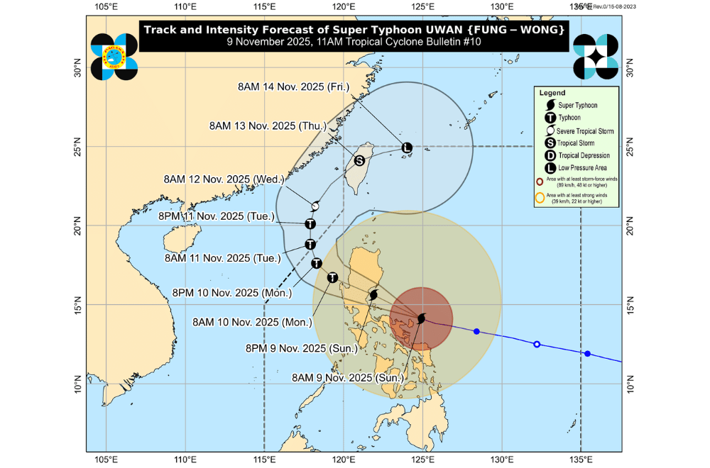
At 11 a.m., the Philippine Atmospheric, Geophysical and Astronomical Services Administration (PAGASA) said the eye of Uwan was located over the coastal waters of Pandan, Catanduanes, moving west northwest at 30 kilometers per hour (km/h).
It packed maximum sustained winds of 185 km/h near the center and gusts reaching up to 230 km/h.
According to PAGASA, Uwan’s impact remains life-threatening, with extreme winds and storm surges already being felt across parts of Bicol, especially Catanduanes, Camarines Norte, and Camarines Sur.
PAGASA said Uwan is forecast to pass close to Calaguas and Polillo Islands before hitting the central portion of Aurora at or near its peak strength.
A “direct hit,” meaning the eyewall could pass over these islands even without a landfall, remains possible.
After crossing Aurora, Uwan will move across the mountainous areas of Northern Luzon, weakening slightly but staying as a typhoon as it exits through Lingayen Gulf or the coastal waters of Pangasinan or La Union by Monday morning.
It will then move toward Taiwan and is expected to weaken further by midweek.
AREAS UNDER TROPICAL CYCLONE WIND SIGNALS
Areas under Wind Signal No. 5 (typhoon-force winds, 185 km/h or higher)
- Central portion of Aurora (San Luis, Baler, Maria Aurora, Dipaculao)
- Polillo Islands
- Northern portion of Camarines Norte (Daet, Talisay, Paracale, Vinzons, Jose Panganiban, Mercedes, Basud)
- Eastern portion of Camarines Sur (Siruma, Caramoan, Garchitorena, Tinambac, Lagonoy)
- Catanduanes
Areas under Wind Signal No. 4 (typhoon-force winds, 118–184 km/h)
- Southern portion of Isabela (San Agustin, Jones, Echague, Dinapigue, San Guillermo)
- Quirino
- Eastern portion of Nueva Vizcaya (Dupax del Sur, Dupax del Norte, Alfonso Castañeda, Kasibu)
- The rest of Aurora
- Nueva Ecija
- Easternmost portion of Pampanga (Candaba)
- Northern and eastern portions of Bulacan (Doña Remedios Trinidad, San Miguel, San Ildefonso, Norzagaray, San Rafael)
- Northern and eastern portions of Quezon (Tagkawayan, Calauag, Guinayangan, Perez, Alabat, Quezon, Infanta, General Nakar, Real)
- The rest of Camarines Norte
- The rest of Camarines Sur
- Northeastern portion of Albay (Rapu-Rapu, Bacacay, City of Tabaco, Malilipot, Malinao, Tiwi, Polangui)
Areas under Wind Signal No. 3 (storm-force winds, 89–117 km/h)
- Southern portion of mainland Cagayan (Tuao, Enrile, Solana, Tuguegarao City, Peñablanca, Iguig, Piat, Amulung)
- The rest of Isabela
- The rest of Nueva Vizcaya
- Southern portion of Apayao (Conner)
- Kalinga
- Abra
- Mountain Province
- Ifugao
- Benguet
- Ilocos Sur
- La Union
- Pangasinan
- Zambales
- Bataan
- Tarlac
- The rest of Pampanga
- The rest of Bulacan
- Metro Manila
- Cavite
- Batangas
- Rizal
- Laguna
- The rest of Quezon
- Marinduque
- The rest of Albay
- Sorsogon
- Ticao and Burias Islands
- Northern Samar
Areas under Wind Signal No. 2 (gale-force winds, 62–88 km/h)
- The rest of Cagayan including Babuyan Islands
- The rest of Apayao
- Ilocos Norte
- Occidental Mindoro including Lubang Islands
- Oriental Mindoro
- Romblon
- The rest of Masbate
- Eastern Samar
- Samar
- Biliran
- Northern and central portions of Leyte (Leyte, Calubian, San Isidro, Tabango, Capoocan, Carigara, Barugo, San Miguel, Babatngon, Tacloban City, Alangalang, Tunga, Palo, Santa Fe, Pastrana, Matag-Ob, Tolosa, Mayorga, Julita, Dagami, Jaro, Villaba, La Paz, Tabontabon, Tanauan, Ormoc City, Dulag, Burauen, Kananga, Albuera, Palompon, Merida, Isabel)
Areas under Wind Signal No. 1 (strong winds, 39–61 km/h)
- Batanes
- Calamian Islands
- Cuyo Islands
- The rest of Leyte
- Southern Leyte
- Bohol
- Northern and central portions of Cebu (Medellin, Daanbantayan, City of Bogo, Tabogon, San Remigio, Tabuelan, Borbon, Sogod, Tuburan, Catmon, Carmen, Danao City, Compostela, Liloan, Consolacion, Lapu-Lapu City, Mandaue City, Cordova, Asturias, Cebu City, Balamban, City of Talisay, Toledo City, Minglanilla, Dumanjug, Argao, Sibonga, Barili, Ronda, Moalboal, Badian, Dalaguete, Alcantara, City of Carcar, City of Naga, San Fernando, Pinamungahan, Aloguinsan) including Bantayan and Camotes Islands
- Northern and central portions of Negros Occidental (City of Escalante, Toboso, Sagay City, Cadiz City, Calatrava, Manapla, City of Victorias, Enrique B. Magalona, Silay City, City of Talisay, San Carlos City, Salvador Benedicto, Murcia, Bacolod City, Hinigaran, City of Himamaylan, Binalbagan, Isabela, Moises Padilla, La Castellana, Pontevedra, San Enrique, La Carlota City, Bago City, Valladolid, Pulupandan)
- Northern portion of Negros Oriental (Canlaon City, Jimalalud, La Libertad, Tayasan, Vallehermoso, City of Guihulngan)
- Guimaras
- Iloilo
- Capiz
- Aklan
- Antique
- Dinagat Islands
- Surigao del Norte
- Northern portion of Agusan del Norte (Tubay, Santiago, Jabonga, Kitcharao)
- Northern portion of Surigao del Sur (Carrascal, Cantilan, Madrid, Carmen, Lanuza, Cortes)
Storm surges exceeding three meters are likely within the next 48 hours along low-lying coastal communities of Catanduanes, Camarines Norte, Camarines Sur, Quezon, Aurora, Metro Manila, and nearby provinces, PAGASA warned.
Residents in these areas are urged to evacuate if advised by local authorities.
Sea conditions across Luzon and the Visayas remain extremely dangerous.
Waves could reach up to 14 meters high along the eastern coasts of Catanduanes, Camarines Norte, and Aurora. Sea travel is suspended across affected waters, and small boats and all types of vessels are advised to stay in port until the weather improves.
PAGASA reminded the public not to focus solely on the typhoon’s center track, as heavy rains, destructive winds, and coastal flooding can affect areas far from where the eye passes.
Residents in high-risk areas are urged to stay alert for evacuation advisories and updates from local authorities.
