


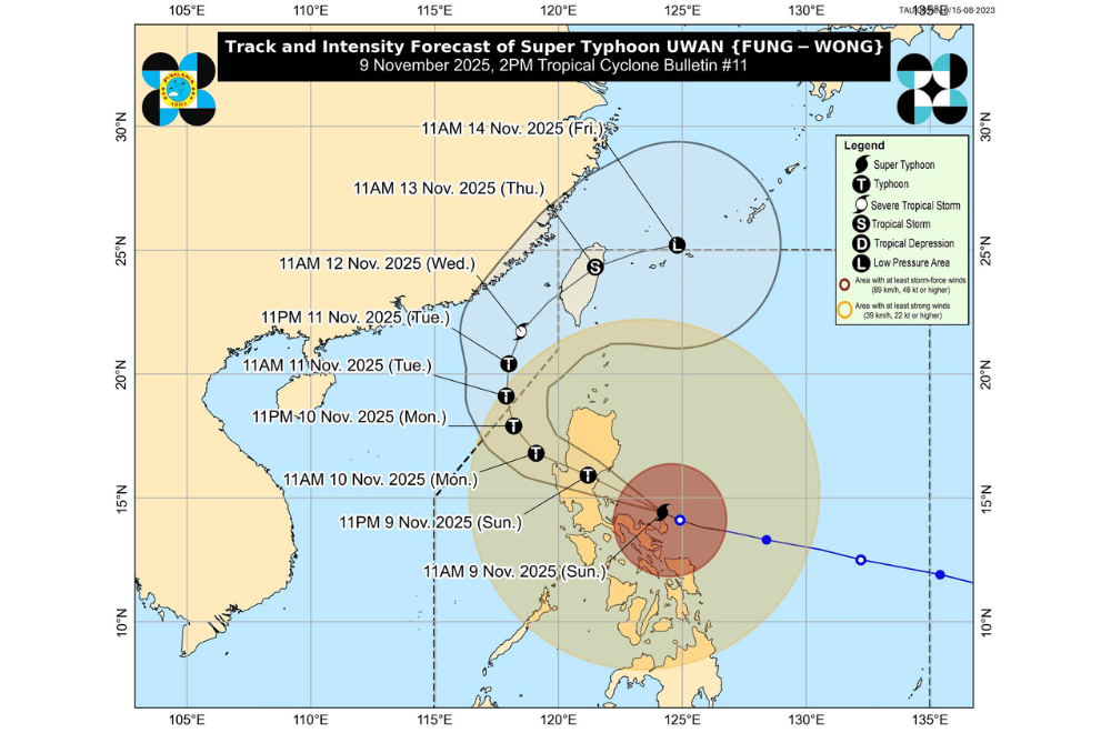
Super Typhoon #UwanPH continued to lash the Bicol Region afternoon on Sunday, November 9, 2025, bringing life-threatening winds, torrential rain, and powerful storm surges as it moved closer to the Aurora coastline, according to PAGASA's 2 p.m. bulletin.
At 1 p.m., the center of Uwan was spotted 100 kilometers northeast of Daet, Camarines Norte, with maximum sustained winds of 185 kilometers per hour (km/h) and gusts reaching 230 km/h. It was moving west-northwest at 30 km/h.
The typhoon’s winds extend up to 900 kilometers from its center.
Uwan is expected to pass close to the Calaguas and Polillo Islands this evening before making landfall in Aurora province late tonight or early Monday morning.
PAGASA said a “direct hit” where the typhoon’s eyewall passes directly over these islands even without landfall is also possible.
After crossing Aurora, Uwan will move across the mountains of Northern Luzon, likely weakening but remaining a typhoon as it exits toward Lingayen Gulf or the coastal waters of Pangasinan or La Union by Monday morning.
It will then head toward Taiwan and is expected to weaken further by midweek.
AREAS UNDER TROPICAL CYCLONE WIND SIGNALS
Areas under Wind Signal No. 5 (typhoon-force winds, 185 km/h or higher)
- Southern portion of Quirino (Nagtipunan)
- Southeastern portion of Nueva Vizcaya (Alfonso Castañeda, Dupax del Norte, Dupax del Sur)
- Northeastern portion of Nueva Ecija (Bongabon, Carranglan, Pantabangan)
- Central portion of Aurora (San Luis, Baler, Maria Aurora, Dipaculao, Dinalungan)
- Polillo Islands
- Northern portion of Camarines Norte (Daet, Talisay, Paracale, Vinzons, Jose Panganiban, Mercedes, Basud)
- Northern and eastern portions of Camarines Sur (Siruma, Caramoan, Garchitorena, Tinambac, Lagonoy)
- Northern portion of Catanduanes (Pandan, Bagamanoc, Panganiban, Viga, Caramoran)
Areas under Wind Signal No. 4 (typhoon-force winds, 118–184 km/h)
- Southern portion of Isabela (San Agustin, Jones, Echague, Dinapigue, San Guillermo, Cordon, City of Santiago)
- The rest of Quirino
- The rest of Nueva Vizcaya
- Southern portion of Ifugao (Tinoc, Asipulo, Lamut, Hungduan, Kiangan, Lagawe, Hingyon)
- Benguet
- Southern portion of Ilocos Sur (Sugpon, Alilem)
- La Union
- Pangasinan
- The rest of Aurora
- The rest of Nueva Ecija
- Northernmost portion of Zambales (Santa Cruz)
- Northeastern portion of Tarlac (Camiling, San Clemente, Paniqui, Gerona, Victoria, Pura, Ramos, Moncada, San Manuel, Anao, La Paz, City of Tarlac, Santa Ignacia)
- Easternmost portion of Pampanga (Candaba)
- Eastern portion of Bulacan (Doña Remedios Trinidad, San Miguel, San Ildefonso, Norzagaray, San Rafael)
- Northern portion of Rizal (Rodriguez)
- Northern and eastern portions of Quezon (Tagkawayan, Calauag, Guinayangan, Perez, Alabat, Quezon, Infanta, General Nakar, Real, Mauban)
- The rest of Camarines Norte
- The rest of Camarines Sur
- Northeastern portion of Albay (Rapu-Rapu, Bacacay, City of Tabaco, Malilipot, Malinao, Tiwi, Polangui)
- The rest of Catanduanes
Areas under Wind Signal No. 3 (storm-force winds, 89–117 km/h)
- Southern portion of mainland Cagayan (Tuao, Enrile, Solana, Tuguegarao City, Peñablanca, Iguig, Piat, Amulung, Santo Niño, Alcala, Rizal)
- The rest of Isabela
- Central and southern portions of Apayao (Conner, Kabugao)
- Abra
- Kalinga
- Mountain Province
- The rest of Ifugao
- Southern portion of Ilocos Norte (Sarrat, Piddig, Paoay, Marcos, Bacarra, Banna, Currimao, Pinili, Carasi, San Nicolas, Dingras, Solsona, Laoag City, Badoc, City of Batac, Nueva Era)
- The rest of Ilocos Sur
- The rest of Zambales
- Bataan
- The rest of Tarlac
- The rest of Pampanga
- The rest of Bulacan
- Metro Manila
- Cavite
- Batangas
- The rest of Rizal
- Laguna
- The rest of Quezon
- Marinduque
- The rest of Albay
- Sorsogon
- Ticao and Burias Islands
- Northern Samar
Areas under Wind Signal No. 2 (gale-force winds, 62–88 km/h)
- The rest of Cagayan including Babuyan Islands
- The rest of Apayao
- The rest of Ilocos Norte
- Occidental Mindoro including Lubang Islands
- Oriental Mindoro
- Romblon
- The rest of Masbate
- Eastern Samar
- Samar
- Biliran
- Northern and central portions of Leyte (Leyte, Calubian, San Isidro, Tabango, Capoocan, Carigara, Barugo, San Miguel, Babatngon, Tacloban City, Alangalang, Tunga, Palo, Santa Fe, Pastrana, Matag-Ob, Tolosa, Mayorga, Julita, Dagami, Jaro, Villaba, La Paz, Tabontabon, Tanauan, Ormoc City, Dulag, Burauen, Kananga, Albuera, Palompon, Merida, Isabel)
Areas under Wind Signal No. 1 (strong winds, 39–61 km/h)
- Batanes
- Northern portion of Palawan (Taytay, Dumaran, El Nido, Araceli, Roxas, San Vicente) including Calamian, Cuyo, and Cagayancillo Islands
- The rest of Leyte
- Southern Leyte
- Bohol
- Cebu including Bantayan and Camotes Islands
- Negros Oriental
- Negros Occidental
- Siquijor
- Guimaras
- Iloilo
- Capiz
- Aklan
- Antique
- Dinagat Islands
- Surigao del Norte
- Northern portion of Agusan del Norte (Tubay, Santiago, Jabonga, Kitcharao)
- Northern portion of Surigao del Sur (Carrascal, Cantilan, Madrid, Carmen, Lanuza, Cortes)
PAGASA said rainfall could exceed 200 millimeters in parts of Isabela, Quirino, Nueva Vizcaya, Kalinga, Benguet, Zambales, Aurora, Nueva Ecija, Quezon, Camarines Norte, Camarines Sur, Catanduanes, and Albay until Monday noon.
Flooding and landslides are likely, especially in mountainous and low-lying areas that have already been soaked by earlier rains.
Storm surges over three meters high are expected within the next 48 hours along low-lying coastal areas of Catanduanes, Camarines Norte, Quezon, Aurora, Zambales, Metro Manila, Cavite, Batangas, and nearby provinces. Residents are urged to evacuate if advised by local authorities.
Sea conditions across Luzon and the Visayas remain extremely dangerous. Waves could reach up to 14 meters along eastern Luzon coasts. PAGASA warned all vessels to stay in port, while small boats should not attempt to sail in any affected waters.
PAGASA advised the public to prepare for more strong winds and heavy rains tonight as Uwan nears landfall. The agency reminded everyone not to focus only on the typhoon’s center, as severe weather can reach far from the eye.
