


At least eight areas were placed under the highest warning level, Tropical Cyclone Wind Signal No. 5, on Sunday, November 9, 2025, as Typhoon Uwan barrelled toward landfall.
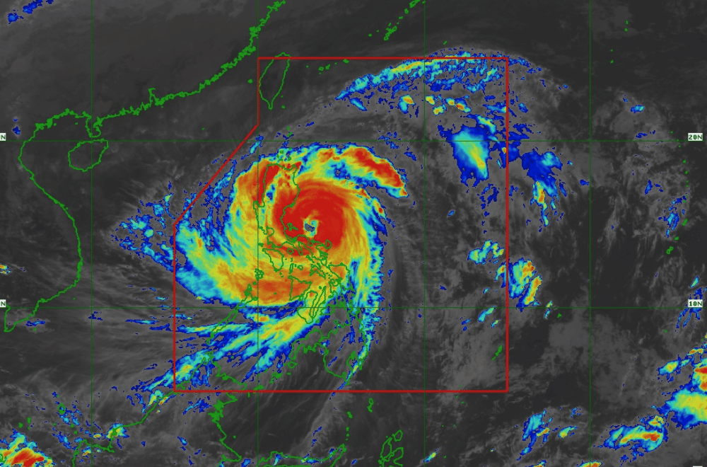
Super Typhoon #UwanPH stretched its deadly reach across nearly the entire Philippines, with wind fields extending up to 900 kilometers and rain bands spanning over 1,500 kilometers.
At 1 p.m., the storm’s center was located 100 kilometers northeast of Daet, Camarines Norte, packing maximum sustained winds of 185 km/h and gusts of up to 230 km/h. It was moving west-northwest at 30 km/h.
PAGASA warned that destructive winds, torrential rains, and dangerous storm surges could affect areas far from the typhoon’s center.
The areas under Signal No. 5, which indicates typhoon-force winds capable of destroying property and uprooting trees, include:
- Southern portion of Quirino (Nagtipunan)
- Southeastern portion of Nueva Vizcaya (Alfonso Castañeda, Dupax del Norte, Dupax del Sur)
- Northeastern portion of Nueva Ecija (Bongabon, Carranglan, Pantabangan)
- Central portion of Aurora (San Luis, Baler, Maria Aurora, Dipaculao, Dinalungan)
- Polillo Islands
- Northern portion of Camarines Norte (Daet, Talisay, Paracale, Vinzons, Jose Panganiban, Mercedes, Basud)
- Northern and eastern portions of Camarines Sur (Siruma, Caramoan, Garchitorena, Tinambac, Lagonoy)
- Northern portion of Catanduanes (Pandan, Bagamanoc, Panganiban, Viga, Caramoran)
Uwan is expected to pass near the Calaguas and Polillo Islands Sunday night before making landfall in Aurora late Sunday night or early Monday morning.
PAGASA said a “direct hit” could occur if the typhoon’s eyewall passes directly over these islands even without landfall. After crossing Aurora, Uwan is likely to move across the mountains of Northern Luzon, weakening slightly but remaining a typhoon before heading toward the Philippine Sea and Taiwan.
The typhoon’s size means even areas outside its direct path will face severe impacts.
Storm surges of more than three meters are possible along low-lying coastal areas in Catanduanes, Camarines Norte, Quezon, Aurora, Zambales, Metro Manila, Cavite, Batangas, and nearby provinces.
Sea conditions across Luzon and the Visayas remain extremely dangerous, with waves reaching up to 14 meters along eastern coasts.
PAGASA advised all vessels to stay in port, while small boats should not attempt to sail in affected waters.
Authorities urged residents to follow evacuation orders and prepare for life-threatening winds and flooding.
PAGASA reminded the public not to focus solely on the typhoon’s center, as hazardous weather can extend far from the eye.
