


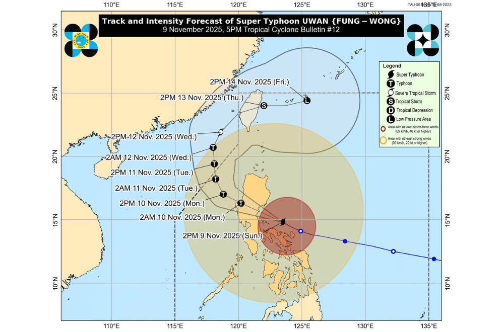
#UwanPH continued to threaten Camarines Norte afternoon on Sunday, November 9, 2025, as it moved west-northwest toward Aurora and the Polillo Islands, bringing life-threatening winds, heavy rains, and dangerous seas.
At 4 p.m., the typhoon’s eye was located 110 kilometers north of Daet, Camarines Norte, or 150 kilometers east-northeast of Infanta, Quezon.
Maximum sustained winds remained at 185 kilometers per hour (km/h) with gusts up to 230 km/h, and the storm was moving at 30 km/h, PAGASA reported.
Typhoon-force winds extend as far as 900 kilometers from the center.
Uwan is forecast to pass near Polillo Islands before making landfall over central Aurora tonight or early Monday.
After crossing Aurora, the typhoon will move over Northern Luzon’s mountains, weakening but remaining a typhoon as it emerges over Lingayen Gulf or nearby coastal waters tomorrow morning.
By midweek, it will turn toward the Taiwan Strait, making landfall over western Taiwan on Thursday before weakening further.
AREAS UNDER TROPICAL CYCLONE WIND SIGNALS
Areas under Wind Signal No. 5 (typhoon-force winds, 185 km/h or higher)
- Southern portion of Quirino (Nagtipunan)
- Southeastern portion of Nueva Vizcaya (Alfonso Castañeda, Dupax del Norte, Dupax del Sur)
- Northeastern portion of Nueva Ecija (Bongabon, Carranglan, Pantabangan), the central portion of Aurora (San Luis, Baler, Maria Aurora, Dipaculao, Dinalungan)
- Polillo Islands
- Northern portion of Camarines Norte (Paracale, Vinzons) including Calaguas Islands
Areas under Wind Signal No. 4 (typhoon-force winds, 118–184 km/h)
- Southern portion of Isabela (San Agustin, Jones, Echague, Dinapigue, San Guillermo, Cordon, City of Santiago)
- The rest of Quirino
- The rest of Nueva Vizcaya
- Southern portion of Mountain Province (Tadian, Bauko, Sabangan)
- Southern portion of Ifugao (Tinoc, Asipulo, Lamut, Kiangan, Lagawe, Hingyon, Hungduan)
- Benguet
- Southern portion of Ilocos Sur (Sugpon, Alilem, Cervantes, City of Candon, Santa Lucia, Suyo, Sigay, Galimuyod, Tagudin, Santa Cruz, Salcedo, San Esteban, Santiago)
- La Union
- Pangasinan
- The rest of Aurora
- The rest of Nueva Ecija
- Northernmost portion of Zambales (Santa Cruz)
- Northeastern portion of Tarlac (Camiling, San Clemente, Paniqui, Gerona, Victoria, Pura, Ramos, Moncada, San Manuel, Anao, La Paz, City of Tarlac, Santa Ignacia)
- Easternmost portion of Pampanga (Candaba)
- Eastern portion of Bulacan (Doña Remedios Trinidad, San Miguel, San Ildefonso, Norzagaray, San Rafael)
- Northern portion of Rizal (Rodriguez)
- Northern and eastern portions of Quezon (Tagkawayan, Calauag, Guinayangan, Perez, Alabat, Quezon, Infanta, General Nakar, Real, Mauban)
- The rest of Camarines Norte
- Northern portion of Camarines Sur (Del Gallego, Ragay, Lupi, Cabusao, Sipocot, Libmanan, Bombon, Calabanga, Canaman, Magarao, Tinambac, Siruma, Goa, Tigaon, Pasacao, Milaor, Gainza, Naga City, Pamplona, Camaligan, San Jose, Lagonoy, Presentacion, Garchitorena, Caramoan)
- Northern portion of Catanduanes (Caramoran, Bagamanoc, Pandan, Panganiban)
Areas under Wind Signal No. 3 (storm-force winds, 89–117 km/h)
- Southern portion of mainland Cagayan (Tuao, Enrile, Solana, Tuguegarao City, Peñablanca, Iguig, Piat, Amulung, Santo Niño, Alcala, Rizal)
- The rest of Isabela
- Northwestern, central, and southern portions of Apayao (Conner, Kabugao, Calanasan)
- Abra
- Kalinga
- The rest of Mountain Province
- The rest of Ifugao
- Ilocos Norte
- The rest of Ilocos Sur
- The rest of Zambales
- Bataan
- The rest of Tarlac
- The rest of Pampanga
- The rest of Bulacan
- Metro Manila
- Cavite
- Batangas
- The rest of Rizal
- Laguna
- The rest of Quezon
- Marinduque
- The rest of Camarines Sur
- The rest of Catanduanes
- Albay
- Sorsogon
- Ticao and Burias Islands
- Northwestern portion of Northern Samar (San Isidro, San Vicente, San Antonio, Capul, Lavezares, San Jose, Victoria, Allen, Rosario, Bobon, Catarman, Biri)
Areas under Wind Signal No. 2 (gale-force winds, 62–88 km/h)
- Babuyan Islands
- The rest of mainland Cagayan
- The rest of Apayao
- Occidental Mindoro
- Oriental Mindoro
- Romblon
- The rest of Masbate
- The rest of Northern Samar
- Northern portion of Samar (Calbayog City, Santo Niño, Almagro, Tagapul-An, Tarangnan, San Jorge, Pagsanghan, Gandara, Santa Margarita, Matuguinao, San Jose de Buan)
- Northern portion of Eastern Samar (Maslog, Arteche, Oras, San Policarpo, Jipapad, Dolores)
Areas under Wind Signal No. 1 (strong winds, 39–61 km/h)
- Batanes
- Northern portion of Palawan (Taytay, Dumaran, El Nido, Araceli, Roxas, San Vicente) including Calamian, Cuyo, and Cagayancillo Islands
- The rest of Samar
- The rest of Eastern Samar
- Biliran
- Leyte
- Southern Leyte
- Cebu
- Bohol
- Siquijor
- Negros Oriental
- Negros Occidental
- Guimaras
- Iloilo
- Capiz
- Aklan
- Antique
- Dinagat Islands
- Surigao del Norte
Heavy rainfall is expected to continue, with over 200 millimeters forecast in Isabela, Quirino, Nueva Vizcaya, Kalinga, Mountain Province, Ifugao, Benguet, La Union, Zambales, Aurora, Nueva Ecija, Quezon, Bulacan, Camarines Norte, Camarines Sur, Catanduanes, and Albay until Tuesday afternoon. Floods and landslides remain likely, especially in mountainous or already waterlogged areas.
Life-threatening storm surges over three meters are possible in low-lying coastal communities from Cagayan Valley to Bicol, including Metro Manila, CALABARZON, and Palawan. Residents in vulnerable areas are urged to evacuate if instructed by local authorities.
Sea conditions remain extremely hazardous, with waves reaching up to 14 meters along the coasts of Isabela, Aurora, Camarines Norte, and parts of Polillo Islands. PAGASA warned all vessels to remain in port, and small boats should avoid going to sea entirely.
Authorities urge residents and disaster offices to take all necessary precautions to protect life and property, monitor local warnings, and follow evacuation orders as conditions worsen.
