


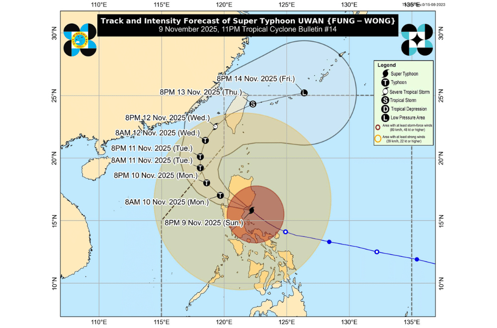
Super Typhoon #UwanPH crossed Aurora late evening on Sunday, November 9, 2025, bringing destructive winds, intense rains, and dangerous sea conditions across much of Luzon, according to PAGASA's 11 p.m. bulletin.
At 10 p.m., the typhoon’s eye was located in the vicinity of Kasibu, Nueva Vizcaya, after making landfall over Dinalungan, Aurora around 9:10 p.m.
It carried maximum sustained winds of 185 kilometers per hour (km/h) near the center and gusts of up to 230 km/h, while moving northwest at 30 km/h.
Typhoon-force winds extend up to 900 kilometers from its center.
PAGASA said Uwan will continue crossing Northern Luzon overnight before emerging over Lingayen Gulf or the coast of La Union or Ilocos Sur by Monday morning.
The system is expected to weaken as it interacts with the mountains but will remain a typhoon.
By midweek, Uwan will move toward the Taiwan Strait and is forecast to make landfall in western Taiwan by Thursday, November 13, before weakening further.
AREAS UNDER TROPICAL CYCLONE WIND SIGNALS
Areas under Wind Signal No. 5 (typhoon-force winds, 185 km/h or higher)
- Southern portion of Quirino (Nagtipunan)
- Southeastern portion of Nueva Vizcaya (Alfonso Castañeda, Dupax del Norte, Dupax del Sur)
- Northeastern portion of Nueva Ecija (Bongabon, Carranglan, Pantabangan)
- Northern and central portion of Aurora (San Luis, Baler, Maria Aurora, Dipaculao, Dinalungan, Casiguran)
Areas under Wind Signal No. 4 (typhoon-force winds, 118–184 km/h)
- Southwestern portion of Cagayan (Enrile, Solana, Tuao, Piat, Rizal)
- Isabela
- The rest of Quirino
- The rest of Nueva Vizcaya
- Southern portion of Apayao (Conner)
- Abra
- Kalinga
- Mountain Province
- Ifugao
- Benguet
- Southern portion of Ilocos Norte (Nueva Era, Badoc, Pinili, Currimao, Banna, Marcos, City of Batac, Paoay, Dingras, Solsona, Sarrat, San Nicolas, Laoag City)
- Ilocos Sur
- La Union
- Pangasinan
- The rest of Aurora
- The rest of Nueva Ecija
- The eastern and central portions of Bulacan (Doña Remedios Trinidad, San Miguel, San Ildefonso, Norzagaray, San Rafael)
- Northern and eastern portions of Tarlac (Camiling, San Clemente, Paniqui, Gerona, Victoria, Pura, Ramos, Moncada, San Manuel, Anao, La Paz, City of Tarlac, Santa Ignacia, Concepcion)
- Eastern portion of Pampanga (Candaba, Arayat, Magalang)
- Northern portion of Zambales (Santa Cruz)
- Northern portion of Quezon (Infanta, General Nakar) including Polillo Islands
Areas under Wind Signal No. 3 (storm-force winds, 89–117 km/h)
- The rest of mainland Cagayan
- The rest of Apayao
- The rest of Ilocos Norte
- The rest of Tarlac
- The rest of Pampanga
- The rest of Bulacan
- The rest of Zambales
- Bataan
- Metro Manila
- Rizal
- Laguna
- Batangas
- Cavite
- Central portion of Quezon (Pitogo, Lucena City, Pagbilao, Tiaong, Lopez, Unisan, Plaridel, San Antonio, Candelaria, Lucban, Sampaloc, Padre Burgos, Sariaya, City of Tayabas, Dolores, Agdangan, Gumaca, Atimonan, Calauag, Quezon, Alabat, Mauban, Perez, Tagkawayan, Guinayangan, Real)
- Camarines Norte
Areas under Wind Signal No. 2 (gale-force winds, 62–88 km/h)
- Babuyan Islands
- The rest of Quezon
- Marinduque
- Romblon
- Oriental Mindoro
- Occidental Mindoro including Libang Islands
- Camarines Sur
- Catanduanes
- Albay
- Sorsogon
- Northern and central portions of Masbate (City of Masbate, Mobo, Aroroy, Balud, Mandaon, Milagros, Baleno, Uson) including Ticao and Burias Islands
Areas under Wind Signal No. 1 (strong winds, 39–61 km/h)
- Batanes
- Northern portion of Palawan (Taytay, Dumaran, El Nido, Araceli, Roxas, San Vicente) including Calamian Islands, Cuyo Islands, and Cagayancillo Islands
- The rest of Masbate
- Northern Samar
- Eastern Samar
- Samar
- Biliran
- Leyte
- Northeastern portion of Bohol (Talibon, Getafe, Bien Unido, Trinidad, Ubay, Pres. Carlos P. Garcia, Buenavista, San Miguel, Danao, Inabanga, Clarin)
- Northern and central portions of Cebu (Medellin, Daanbantayan, City of Bogo, Tabogon, San Remigio, Tabuelan, Borbon, Sogod, Tuburan, Catmon, Carmen, Danao City, Compostela, Liloan, Consolacion, Lapu-Lapu City, Mandaue City, Cordova, Asturias, Cebu City, Balamban, City of Talisay, Toledo City, Minglanilla, Dumanjug, Sibonga, Barili, City of Carcar, City of Naga, San Fernando, Pinamungahan, Aloguinsan, Ronda) including Bantayan and Camotes Islands
- Northern portion of Negros Oriental (Canlaon City, Vallehermoso, City of Guihulngan, La Libertad)
- Northern and central portions of Negros Occidental (City of Escalante, Toboso, Sagay City, Cadiz City, Calatrava, Manapla, City of Victorias, Enrique B. Magalona, Silay City, City of Talisay, San Carlos City, Salvador Benedicto, Murcia, Bacolod City, Hinigaran, Isabela, Moises Padilla, La Castellana, Pontevedra, San Enrique, La Carlota City, Bago City, Valladolid, Pulupandan, Binalbagan, City of Himamaylan, City of Kabankalan, Ilog)
- Guimaras
- Iloilo
- Capiz
- Aklan
- Antique including Caluya Islands
The weather bureau warned of widespread flooding and landslides, particularly in mountainous areas and low-lying towns in Cagayan Valley, Cordillera, and Central Luzon.
Continuous heavy to torrential rains are expected through Monday as Uwan moves inland.
Life-threatening storm surges over three meters high may inundate coastal communities in Ilocos Region, Cagayan Valley, Central Luzon, Metro Manila, CALABARZON, Bicol Region, and parts of the Visayas.
Coastal residents are urged to evacuate to higher ground if advised by local authorities.
Sea travel remains extremely dangerous, with waves reaching up to 14 meters along the coasts of Isabela, Aurora, and Camarines Norte, and up to 12 meters in Catanduanes and Camarines Sur.
A Gale Warning is in effect over most seaboards of Luzon and Visayas.
Authorities urge residents to stay alert for updates, follow evacuation orders, and coordinate with disaster officials as the typhoon continues to bring destructive winds, flooding, and dangerous coastal conditions.
