


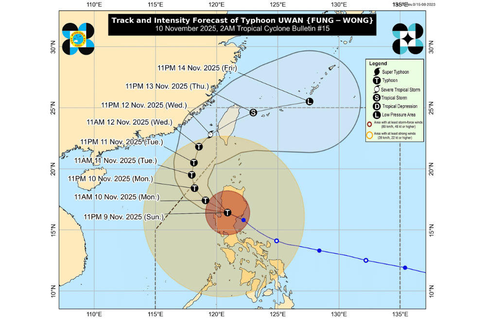
#UwanPH weakened slightly and downgraded into a typhoon after crossing Northern Luzon early Monday, November 10, 2025, but continued to bring strong winds, heavy rains, and rough seas across most of the country, according to PAGASA.
At 1 a.m., the eye of Uwan was located over Bagulin, La Union, packing maximum sustained winds of 165 kilometers per hour (km/h) near the center, gusts of up to 275 km/h, and moving northwest at 30 km/h. The typhoon’s winds extend up to 780 kilometers from its center.
Uwan is expected to move northwest and reemerge over the West Philippine Sea this morning, maintaining its typhoon strength until Tuesday. It will then gradually weaken as it moves northward toward the Taiwan Strait by midweek.
PAGASA said Uwan could make landfall in western Taiwan by Thursday, November 13, before weakening into a low-pressure area as it exits toward the Ryukyu Islands.
AREAS UNDER TROPICAL CYCLONE WIND SIGNALS
Areas under Wind Signal No. 4 (typhoon-force winds, 118–184 km/h)
- Southwestern portion of Isabela (Cordon, City of Santiago, Echague, Jones, San Agustin, San Guillermo, San Isidro, Alicia, Angadanan, Ramon, San Mateo, City of Cauayan, Benito Soliven, Naguilian, Reina Mercedes, Luna, Cabatuan, Aurora, San Manuel, Roxas, Mallig, Quirino, Burgos, Gamu, Quezon)
- Quirino
- Nueva Vizcaya
- Southern portion of Kalinga (City of Tabuk, Tanudan, Tinglayan, Pasil, Lubuagan)
- Mountain Province
- Southern portion of Abra (Tubo, Luba, Boliney, Villaviciosa, Pilar, Daguioman, Bucloc, Manabo, San Isidro, San Quintin, Pidigan)
- Ifugao
- Benguet
- Central and southern portions of Ilocos Sur (Narvacan, Nagbukel, Santa Maria, Burgos, San Esteban, Santiago, Banayoyo, Lidlidda, San Emilio, Quirino, Cervantes, Gregorio del Pilar, Sigay, Suyo, Alilem, Salcedo, Galimuyod, City of Candon, Santa Lucia, Santa Cruz, Tagudin, Sugpon)
- La Union
- Pangasinan
- Aurora
- Nueva Ecija
- Northern and eastern portions of Tarlac (Concepcion, La Paz, Victoria, City of Tarlac, Gerona, Pura, Ramos, Paniqui, Anao, San Manuel, Moncada, Camiling, San Clemente, Santa Ignacia, Mayantoc)
- Northern portion of Zambales (Santa Cruz, Candelaria)
Areas under Wind Signal No. 3 (storm-force winds, 89–117 km/h)
- Central and southern portions of mainland Cagayan (Rizal, Santo Niño, Alcala, Baggao, Peñablanca, Amulung, Iguig, Tuguegarao City, Solana, Tuao, Piat, Enrile)
- The rest of Isabela
- Southern portion of Apayao (Pudtol, Kabugao, Conner)
- The rest of Kalinga
- The rest of Abra
- Southern portion of Ilocos Norte (Nueva Era, Solsona, Dingras, Marcos, Banna, City of Batac, Paoay, Currimao, Pinili, Badoc)
- The rest of Ilocos Sur
- Bulacan
- Pampanga
- The rest of Tarlac
- The rest of Zambales
- Bataan
- Northern portion of Metro Manila (Caloocan City, Quezon City, City of Marikina, City of Valenzuela, City of Malabon, City of Navotas)
- Northern and eastern portions of Rizal (Rodriguez, San Mateo, Tanay, City of Antipolo)
- Northern portion of Quezon (General Nakar)
Areas under Wind Signal No. 2 (gale-force winds, 62–88 km/h)
- The rest of Apayao
- The rest of Ilocos Norte
- The rest of Quezon including Polillo Islands
- The rest of Metro Manila
- The rest of Rizal
- Laguna
- Cavite
- Batangas
- Marinduque
- Northern portion of Oriental Mindoro (Pola, Naujan, City of Calapan, Victoria, Baco, Puerto Galera, San Teodoro, Socorro, Pinamalayan, Gloria)
- Northern and central portions of Occidental Mindoro (Abra de Ilog, Paluan, Mamburao, Santa Cruz, Sablayan) including Lubang Islands
- Camarines Norte
- Northwestern portion of Camarines Sur (Del Gallego, Ragay, Lupi, Sipocot)
- The rest of mainland Cagayan including Babuyan Islands
Areas under Wind Signal No. 1 (strong winds, 39–61 km/h)
- Batanes
- Northern portion of Palawan (Taytay, Dumaran, El Nido, Araceli, Roxas, San Vicente) including Calamian Islands, Cuyo Islands, and Cagayancillo Islands
- The rest of Camarines Sur
- Catanduanes
- Albay
- Sorsogon
- Masbate including Ticao and Burias Islands
- Romblon
- The rest of Oriental Mindoro
- The rest of Occidental Mindoro
- Northern Samar
- Northern and central portions of Samar (San Jorge, Matuguinao, Almagro, Calbayog City, Jiabong, Pagsanghan, City of Catbalogan, Gandara, Motiong, Santo Niño, Tagapul-An, San Jose de Buan, Santa Margarita, Tarangnan, Paranas, Hinabangan, San Sebastian, Calbiga, Pinabacdao, Villareal, Daram, Zumarraga, Talalora, Santa Rita)
- Northern portion of Eastern Samar (Can-Avid, Maslog, San Policarpo, Taft, Dolores, Jipapad, Oras, Arteche, Sulat)
- Northern portion of Leyte (Tunga, Pastrana, San Miguel, Matag-Ob, Palo, Calubian, Leyte, Carigara, Babatngon, Dagami, Jaro, San Isidro, Santa Fe, Villaba, Palompon, Tabontabon, Tanauan, Merida, Ormoc City, Isabel, Capoocan, Alangalang, Tabango, Tacloban City, Kananga, Barugo)
- Biliran
- Northern portion of Cebu (Medellin, Daanbantayan, City of Bogo, Tabogon, San Remigio, Tabuelan, Borbon, Sogod, Tuburan, Catmon) including Bantayan Islands
- Guimaras
- Northern portion of Negros Occidental (City of Escalante, Toboso, Sagay City, Cadiz City, Calatrava, Manapla, City of Victorias, Enrique B. Magalona, Silay City, City of Talisay, Salvador Benedicto, Murcia, Bacolod City, Bago City, Valladolid, Pulupandan, San Carlos City)
- Iloilo
- Capiz
- Aklan
- Antique including Caluya Islands
PAGASA warned of torrential rainfall exceeding 200 millimeters in La Union, Pangasinan, Isabela, Quirino, Nueva Vizcaya, Kalinga, Mountain Province, Ifugao, Benguet, Tarlac, Zambales, Aurora, and Nueva Ecija until Monday evening.
Moderate to heavy rains (100–200 mm) are expected in Ilocos Region, Cagayan Valley, Central Luzon, Metro Manila, CALABARZON, and parts of MIMAROPA.
By Tuesday, La Union and Benguet may continue to receive up to 200 mm of rain, while surrounding provinces including Pangasinan, Ilocos Sur, Zambales, and Batangas may still experience 50–100 mm of rainfall.
Residents in these areas are advised to remain alert for flash floods and landslides, especially in mountainous and low-lying communities.
Life-threatening storm surges over three meters high are possible within the next 48 hours along coastal areas of Ilocos Region, Cagayan Valley, Central Luzon, Metro Manila, CALABARZON, MIMAROPA, Camarines Provinces, Catanduanes, Masbate, and parts of Western Visayas.
A Gale Warning remains in effect over almost all seaboards of Luzon and Visayas, and parts of Mindanao, with waves reaching up to 14 meters along the coasts of Isabela, Aurora, and Camarines Norte. PAGASA said sea travel remains extremely dangerous, and all vessels are advised to stay in port.
The weather bureau urged residents and local officials to continue monitoring updates and follow safety advisories as strong winds, floods, and coastal hazards persist across large parts of Luzon.
