


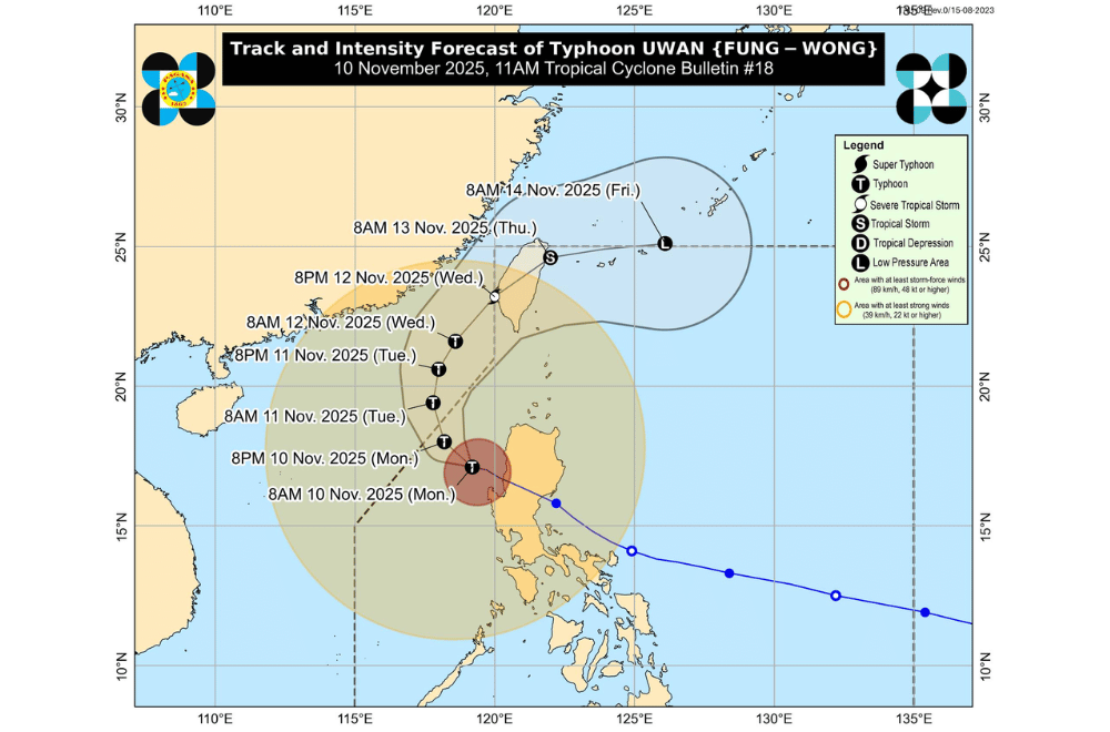
Typhoon #UwanPH weakened slightly late morning on Monday, November 10, 2025, as it moved farther over the West Philippine Sea, but it continued to bring heavy rains, strong winds, and rough seas across Luzon, according to PAGASA's 11 a.m. bulletin.
At 10 a.m., the center of Uwan was located about 135 kilometers west northwest of Bacnotan, La Union, carrying maximum sustained winds of 130 kilometers per hour (km/h) and gusts reaching 160 km/h while moving west northwest at 20 km/h.
PAGASA said the typhoon’s strong winds extend up to 850 kilometers from its center, wide enough to affect most of Luzon.
Uwan is expected to continue moving northwest and leave the Philippine Area of Responsibility (PAR) by tonight or early Tuesday morning.
It may briefly strengthen again over the waters southwest of Taiwan before weakening as it moves northward, possibly making landfall over southwestern Taiwan by Wednesday night, then exiting toward the Ryukyu Islands and weakening into a remnant low by Friday, November 14.
AREAS UNDER TROPICAL CYCLONE WIND SIGNALS
Areas under Wind Signal No. 3 (storm-force winds, 89–117 km/h)
- Ilocos Sur
- Northern and central portions of La Union (Luna, Caba, Santol, Bauang, City of San Fernando, San Juan, Bagulin, Aringay, Bangar, San Gabriel, Burgos, Naguilian, Agoo, Bacnotan, Sudipen, Balaoan)
- Northwestern portion of Pangasinan (Bolinao, Bani, Agno, City of Alaminos, Anda)
Areas under Wind Signal No. 2 (gale-force winds, 62–88 km/h)
- Batanes
- Cagayan including Babuyan Islands
- Isabela
- Quirino
- Nueva Vizcaya
- Apayao
- Abra
- Kalinga
- Mountain Province
- Ifugao
- Benguet
- Ilocos Norte
- The rest of La Union
- The rest of Pangasinan
- Aurora
- Zambales
- Bataan
- Nueva Ecija
- Tarlac
- Pampanga
- Bulacan
Areas under Wind Signal No. 1 (strong winds, 39–61 km/h)
- Metro Manila
- Cavite
- Laguna
- Batangas
- Rizal
- Quezon including Polillo Islands
- Oriental Mindoro
- Occidental Mindoro including Lubang Island
- Marinduque
- Romblon
- Northern portion of Palawan (Taytay, Dumaran, El Nido, Araceli) including Calamian and Cuyo Islands
- Camarines Norte
- Camarines Sur
- Catanduanes
- Albay
- Sorsogon
- Northern and western portions of Masbate (City of Masbate, Mobo, Aroroy, Balud, Mandaon, Milagros, Baleno) including Burias and Ticao Islands
- Aklan
- Capiz
- Northern and central portions of Antique (Pandan, Libertad, Sebaste, Culasi, Tibiao, Barbaza, Bugasong, Laua-An) including Caluya Islands
From today until noon of November 11, PAGASA warned of heavy to intense rainfall (100–200 millimeters) in La Union, Pangasinan, Benguet, and Zambales.
Moderate to heavy rains (50–100 millimeters) are expected in Ilocos Norte, Ilocos Sur, Apayao, Abra, Kalinga, Mountain Province, Ifugao, Cagayan Valley, Central Luzon, Metro Manila, Cavite, Batangas, Rizal, and Occidental Mindoro.
Rainfall may be higher in mountainous areas, and flash floods or landslides are likely in areas with saturated soil from previous rains.
PAGASA warned of life-threatening storm surges over three meters high along the coastal areas of Ilocos Region, Cagayan Valley, Central Luzon, Metro Manila, CALABARZON, most of MIMAROPA, Aklan, and Antique within the next 12 hours.
A Gale Warning remains in effect over northern, central, and southern Luzon’s seaboards.
Seas may reach up to 8 meters high along the coasts of Ilocos Region and Zambales, up to 7 meters in Batanes, Cagayan, and Isabela, and up to 5.5 meters along the Aurora coast and Lubang Islands.
PAGASA said sea travel remains risky for all types of vessels, especially for small boats. Fisherfolk and coastal residents are urged to stay in port or seek shelter until the winds and waves subside.
PAGASA reminded the public not to focus only on the typhoon’s center track, as heavy rains, strong winds, and storm surges may still occur far from the storm’s eye.
