


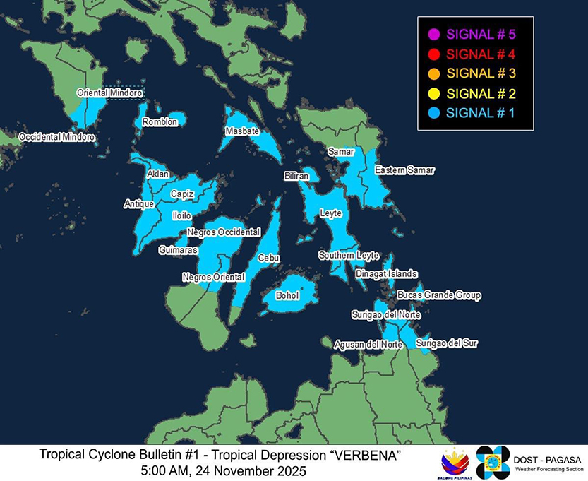
Many areas have been placed under Tropical Cyclone Wind Signal 1 after the Low Pressure Area east of Mindanao developed into Tropical Depression morning on Monday, November 24, 2025, according to PAGASA.
These LGUs include the following:
LUZON:
The southern portion of Occidental Mindoro (Magsaysay, San Jose), the southern portion of Oriental Mindoro (Bulalacao, Mansalay, Roxas, Bongabong), Romblon, and mainland Masbate
VISAYAS:
The central and southern portions of Eastern Samar (Sulat, San Julian, City of Borongan, Maydolong, Balangkayan, Llorente, Lawaan, Balangiga, General Macarthur, Giporlos, Quinapondan, Hernani, Salcedo, Guiuan, Mercedes, Taft), the central and southern portions of Samar (Hinabangan, Marabut, Basey, Santa Rita, Villareal, Pinabacdao, Calbiga, San Sebastian, Daram, Talalora, Zumarraga, Almagro, Santo Niño, Tagapul-An, City of Catbalogan, Jiabong, Motiong, Paranas), Biliran, Leyte, Southern Leyte, the northern and central portions of Cebu (Pinamungahan, Ronda, Liloan, Cebu City, Moalboal, Consolacion, Danao City, Borbon, Carmen, Argao, Daanbantayan, Tuburan, City of Bogo, Alcantara, Tabogon, Badian, Sibonga, City of Naga, Lapu-Lapu City, City of Carcar, Mandaue City, Catmon, Minglanilla, Toledo City, Cordova, Dalaguete, Compostela, San Remigio, Balamban, Dumanjug, Aloguinsan, San Fernando, Asturias, Barili, Medellin, Sogod, Tabuelan, City of Talisay, Alegria, Alcoy) including Bantayan Islands, Camotes Islands, Bohol, the northern portion of Negros Occidental (City of Himamaylan, Binalbagan, Isabela, Hinigaran, Pontevedra, La Carlota City, Moises Padilla, La Castellana, Valladolid, San Enrique, Bago City, Pulupandan, Bacolod City, City of Talisay, Silay City, Enrique B. Magalona, City of Victorias, Manapla, Cadiz City, Sagay City, Calatrava, Toboso, City of Escalante, Salvador Benedicto, San Carlos City, Murcia), the northern portion of Negros Oriental (Tayasan, Jimalalud, La Libertad, City of Guihulngan, Vallehermoso, Canlaon City), Iloilo, Capiz, Aklan, Antique including Caluya Islands and Guimaras
MINDANAO:
Dinagat Islands, Surigao del Norte including Siargao and Bucas Grande Islands, the northern portion of Surigao del Sur (Carrascal, Cantilan, Madrid, Carmen, Lanuza, Cortes, City of Tandag) and the northern portion of Agusan del Norte (Kitcharao, Jabonga, Santiago, Tubay, City of Cabadbaran)
Several LGUs have already suspended face-to-face classes in anticipation of the possible effects of the tropical depression. Read here: https://www.gmanetwork.com/regionaltv/news/111548/lgus-suspend-f2f-classes-due-to-possible-effects-of-lpa/story/
In its 8 a.m. bulletin on Monday, November 24, PAGASA said that Verbena has maximum sustained winds of 45 km/h near the center, gustiness of up to 55 km/h, and central pressure of 1002 hPa. Strong winds may extend outwards up to 200 km from the center.
As of 7 a.m. on Monday, the center of Tropical Depression Verbena was estimated at 290 km East of Surigao City, Surigao del Norte (9.5°N, 128.1°E).
PAGASA said Verbena will move generally west northwestward and will make landfall or pass close over northeastern Mindanao afternoon on November 24 before crossing Visayas and the northern portion of Palawan from November 24 until Wednesday, November 26.
It will then emerge over the West Philippine Sea by Wednesday morning.
Verbena may also intensify slightly prior to making landfall over northeastern Mindanao but will likely cross the Philippine landmass as a tropical depression.
Once it emerges over the West Philippine Sea, it is then forecast to intensify further into a tropical storm, PAGASA said.
