


Four students from two Cebu schools have responded to the call for help following the deadly magnitude 6.9 earthquake that hit northern Cebu on September 30, 2025.
The earthquake killed at least 73 people and injured at least 297.
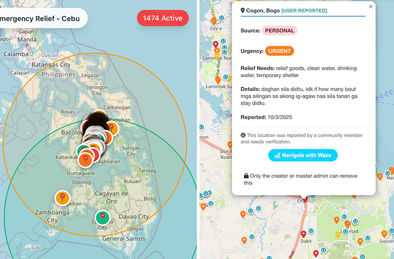
It has affected 47,221 families (170,959 individuals) in Bogo City, San Remigio, Medellin, Tabogon, Sogod, Tabuelan, and Borbon.
With at least 5,000 aftershocks getting recorded four days after the quake and with rehabilitation just beginning, the work is far from ending.
The students helped by doing what they do best - making the most out of being digital natives to build online tools that can connect calamity victims to responders, volunteers, local government units, non-government organizations, and charitable groups.
Vince Clave Igot, Ralph Adriane Dilao, and Clint Alonzo of UC’s College of Computer Studies developed the Cebu Relief App while CTU’s Computer Engineering student Charles Zoilo Yana developed the Northern Cebu Earthquake Relief Map Guide.
RELIEF APP
The Cebu Relief App aims to connect calamity victims with volunteers, local government units (LGUs), non-government organizations (NGOs), and charitable organizations, according to UC in a post.
“With real-time mapping and support features, the app ensures that aid reaches those who need it most, faster and more efficiently. A proud innovation from UC Webmasters, built with compassion and purpose,” UC underscored.
In an interview with GMA Regional TV News, Clint Alonzo said that the developing of the app started from scratch, and that modifications on features are done from time to time to accommodate growing demands.
He said that the effort began with the idea on being of huge help to families of earthquake victims and survivors reeling from the deadly quake in northern Cebu, and to make help more target-specific by determining the number of individuals who need help, their particular location and the items needed such as food, water, hygiene kits, among others.
Clint said that he and Vince are classmates, on their fourth year in Information Technology; while Ralph is in third year. They have forged a bond because of the several competitions they had participated in involving the College of Computer Studies.
"It took us about 32 hours to develop the app, which we aim to be our response to the urgent call for help, especially in other places kay daghan ang nag-comment nga naa pay areas nga wala kaabot didto ang tabang," Clint said.
In fact, he said, they had to pause for a while bothered by the thought of the app not taking off, since telecommunication network services in affected areas are currently down.
"Pero amo mang nakita nga nag-take off na," Clint said, citing over 2,000 feedback as of 2 p.m. on Friday, October 3, 2025.
He said that the proverbial "eureka" came through the help of relatives of victims and survivors who have Internet connectivity in other places not affected severely by the tremor.
"Nag-add mi og features nga maka-help og expand sa information, as relatives in areas nga better ilang situation can access the app for prompt response," Clint added.
Clint urged LGUs to support the program and help its expansion to maximize its potential. He also called on netizens to be very careful in providing information, as the app has its own vulnerabilities.
Clint is glad they do not have to spend a cent on the app since every other program tapped is up for free, but that is also the downside to the app because its database may need to expand the moment its use goes full swing.
As for now, they have to attend to the urgent call of the north.
By 3 p.m. on October 1, 2025, Clint said, they received communication from the Provincial Government of Cebu to proceed to the Capitol for coordination with the operations of the Office of the Governor and the Provincial Disaster Risk Reduction and Management Office in relation to the ongoing relief and rehabilitation efforts in northern Cebu.
How does the app work?
First, people in need create a request by pinning their location and describing what they require.
Second, volunteers, responders, and organizations see these requests and view details by clicking the pinned locations in real-time on the map.
Third, users can get directions to the affected areas, prioritize responses, and update relief status.
Fourth, volunteers can also pin requests on behalf of others, ensuring help reaches everyone even in hard-to-reach locations.
Fifth, the map updates dynamically, helping responders find people faster even in areas with limited connectivity. Key benefits of which include real-time relief coordination, accurate navigation to affected areas, efficient distribution of resources, and enables volunteers and organizations to respond faster and save lives.
Further, the developers has an important note to users: Avoid spam or inaccurate inputs to ensure resources reach those who truly need help.
Developers asked people in need to:
- Pin location to request urgent relief.
- Describe needs, such as food, water, medicine, shelter, and other essentials.
- Every pin represents a family and ensures request reaches responders quickly.
For volunteers, LGUs, NGOs, and donors:
- View all active relief requests in real-time on the map.
- Navigate to pinned locations using the app’s routing feature, allowing faster response and better prioritization of affected areas.
- Search or pin exact locations where urgent help is needed.
- Pin on behalf of someone else - volunteers can create requests for people in need who cannot access the app themselves.
MAPPING WEBSITE
Meanwhile, Yana’s crowdsourced mapping website aims to help responders and donors locate communities affected by the quake.
In a separate post, CTU said “the platform allows users to pin exact locations and share key details, enabling volunteers and relief groups to coordinate assistance more effectively.”
The project, CTU said, is not actually school-related and that Yana built the tool himself because he wanted to help survivors of the quake.
The tool works similarly to Google Maps albeit not fully precise as it relies on free online tools and available application programming interfaces (APIs).
How does it work?
"We have two options to pin locations: one is to search the place there could be, suggest and recommend dropdowns or just simply enter and it will try to locate the location," Yana said, as quoted by the CTU post.
"Second is manually, by clicking that green icon on the lower right corner, users can just zoom and navigate or find the nearest barangay," he added.
He, however, noted a limitation: Most of those affected by the quake may not be online and may not have the devices.
Despite this limitation and despite the project being entirely self-funded, he pushed forward with it with support from his partner who tested the platform and helped promote it.
“Together, they contacted local government units, like Danao, and Facebook influencers to help amplify the tool’s reach, CTU said.
Yana’s admits, humbly:
“My confidence in my project is not that high so I'm also hoping for developers out there to help me."
By October 3, the relief map has recorded more than 500 pinned locations, which CTU said, highlighted its growing role in relief coordination.
