

ADVERTISEMENT
Filtered By: Lifestyle
Lifestyle
Chasing the sheer cliffs of Australia’s Tasman peninsula
+
Make this your preferred source to get more updates from this publisher on Google.
Tasmania, Australia
My husband Alex and I were in Tasmania, the southeastern island of Australia. One morning, our friend Jeff invited us to join him in a nature walk in the national park and forests, promising us “unforgettable views of the sea and the mountains.”
We crossed the Tasman Bridge as the sun rose, slowly warming us after an early morning marked by fog and rain in Hobart, the capital city. We went further on to the Denison Canal Park, where Jeff showed us a huge map on the wall tracing the path that we shall take that day. They had very interesting names: Pirate’s Bay, Eaglehawk’s Neck, Devil’s Kitchen. These certainly piqued our curiosity!
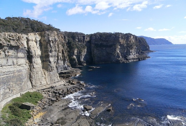
Our first stop was the Pirate’s Bay Drive lookout. Before us was a wide expanse of blue sea, dotted by coves and rocky islands with quaint names like The Lanterns, The Candlestick, and Cape Raoul in the distance.
We were given the option to visit the Tasmanian Devil Conservation Park. A few years ago, for unknown reasons, these small marsupials indigenous to the island suffered an epidemic of fatal Devil’s Facial Tumour Disease. Almost half of the animal population died, and even until our visit, nobody could say why. They only knew that the disease was transferred through bites during fights and mating. Now the Park had begun research on how to reproduce Tasmanian Devils that were cancer-resistant, and hopefully be able to replenish the thinning population. The Park was accessible through the main highway in a town called Taranna, Jeff added.
We continued our way towards Eaglehawk Neck, a section of the peninsula abutting the Tasman Sea. After parking the van, Jeff accompanied us on foot around the Tasman National Park, where we walked on a well-worn path through pine, gum and birch trees, ferns, and some hedges with yellow blooms. It was good to bask in the warm sunlight with the cold wind, smelling the sweet fresh air, the unmistakable fragrance of blue gum resin, and a hint of salty tang.
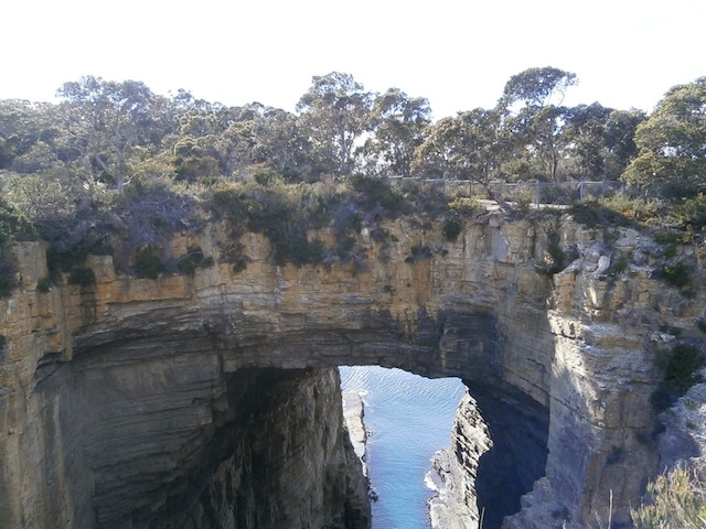
We stopped in one of the lookouts and Jeff pointed out a craggy, multi-layered stone cliff forming a huge arch through which the sea ebbed and flowed. Several millennia ago this was solid rock, but with sea water and wind erosions, a cavity was formed in the rock’s face, and slowly it became a cave, hollowed out after years of patient wearing down by the elements. But the back portion of the cave somehow became thinner and thinner until it finally collapsed, and only the thicker ceiling and the side supports were left, forming this present-day Tasman Arch. Some plants were growing in its “crown,” but one could see the different shades of fine lines representing the layers that accumulated through millions of years to form these rocks.
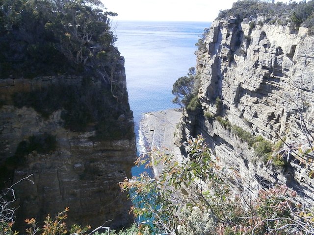 Further on was the Devil’s Kitchen, a chasm 300 meters deep between sheer rock formations. Wind and water again sculpted these cliffs and looking down at the churning sea from our vantage point made one feel vertiginous, what with the strong wind blowing from the east.
 We made our way to the spectacular Tasman Blowhole, which could, when the current was fast and strong, smash into the rocks’ faces sending seawater so many hundred feet up the air through the (with a little imagination!) Tasmania-shaped hole. A plaque warned us to be careful and not to stand too close to the edge, although heavy-duty steel wire meshes were in place for protection. In 1956, a newlywed couple had gone here while on their honeymoon, but unfortunately the two strayed too close to the blowhole; one strong gust of water and wind, and they were swept away into the sea and were never found again. The plaque was donated and put up by their parents as a warning to others.
We passed by Doo Town, a place where all the cottages (except one!) had “Doo” in their names: the first house constructed was named “Doo One” by its owner. The next one was “Doo Me” and the next “Doo Us.” For fun and camaraderie, the other house owners followed suit, so they had hilarious names like “Doo Bee Doo Bee Doo, ” “XanaDoo,” “Doo Come In,” “Love Me Doo,” and so many more “Doos.”
As we slowly wound around the Tasman National Park we noted a big swathe of burnt trees in one area, and Jeff mentioned that there were often forest fires during the summer months. From November to January, the trees could get very dry and become tinder to the slightest flame. Here and there though, as we walked on, we noticed areas of regeneration: green, healthy ferns sprouting up around the burnt boles of birch trees, brave yellow-petalled blooms defying the ruined and charred ground from where they sprang up.
From time to time, we found signs for a look-out, and we could only marvel at the stunning scenery of magnificent rocky cliffs, sunlight reflected on the wide expanse of the sea, and the waves splashing at the foot of these amazing rocks. The cold wind swept our faces, invigorating us as we walked on.
We came upon the tidal platforms called Tessellated Pavements, again formed by eons-long water and wind erosions. There were tile-like imprints in the flat stones, and we were told that turban shells and limpets (both called “sea gardeners”) ate the sea kelp, algae and other microscopic organisms found in the waters; this kept the ecosystem in perfect balance.
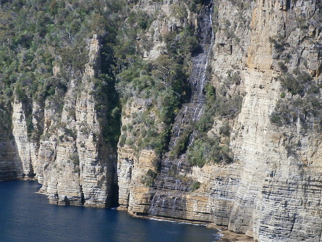
We finally reached Waterfall Bay, which was a serene and blue water area. From the cliffs that formed the background of the curved bay, there was a slender stream of water flowing down from the top, steadily falling from rock to rock, until they reached the waters below. It was good to sit and stay a while, after the almost three-hour trek. The tranquility of the place filled us with joy, as the sun continued to shine brightly. —YA, GMA News
