

ADVERTISEMENT
Filtered By: Scitech
SciTech
Why we need to liberate Philippine public map data
+
Make this your preferred source to get more updates from this publisher on Google.
Despite the tremendous need for maps in helping solve the country’s problems—disasters, climate change, environmental degradation, urban decay, etc.—public map data in the Philippines is either inaccessible, closed, for sale, or any combination of the three.
Why is this so?
Let’s start with the most recent public map to make the headlines: PHIVOLCS' Valley Fault System Atlas. The surge in public interest in a document that is only available from a single site has naturally taken its toll, with people reportedly taking hours—sometimes even days—to download the maps.
To staunch the demand, citizen mappers republished the data in more accessible platforms such as zoomable webmaps. But this move to democratize access drew criticism from authorities who were naturally concerned that citizen mappers might inadvertently misdraw the fault's location.
But try closely comparing the original VFS atlas with this webmap compiled by Prof. Julius Bañgate and other citizen mappers and judge for yourself.
While understandable, the paranoia of our government's data stewards is surpassed by the greater and more urgent paranoia of a public that is in need of answers.
Why is there so much paranoia surrounding map data that should be public to begin with? Whose “fault” is it?
This ironically funny situation has happened a number of times before. Fellow Filipinos, here is how you can enjoy high-quality map data of your town, during “normal” days:
First, you need to send out formal letters of request to various agencies because different map layers—topography, geology, political boundaries, etc.—are held by different agencies.
It's not unheard-of for months to pass, even after numerous follow-up requests, before the data finally arrives. And even then, the data is usually in a "closed" (non-editable .jpg or .pdf) format.
Because the data is "closed", you would have to redraw the map layers to make them ready for validation and to make them readable to the common barangay resident. This may take weeks to months for a team to accomplish.
Thankfully, in times of crisis, agencies have shown themselves capable of stepping up to the plate:
After Super Typhoon Yolanda, our humanitarian mapping team sent out the same letters to various data stewards in government. Some of the map data only took weeks, instead of the usual months, to arrive. Some of the map data were sent in open format (a.k.a. shapefiles), instead of .jpg and .pdf. The topographic data that was previously for sale was now free. It was possible to get access to open and free data due to the disaster.
But why does it take a disaster for data to be released openly, freely, and without much formality?
Bakit kailangang mangyari muna ang trahedya bago ilabas ang datos?
Before the super typhoon, the data was already there—in the personal computers and servers of the bureaucracy. If only the data was accessible, open, and free, then more lives could have been saved.
It is painful.
Why do we have such a situation? Let’s enumerate the challenges.
(1) The map data is inaccessible
High-quality data might exist, but it might also be out of reach of the average Filipino.
First of all, there are past and current government groups that produce high-quality data and to whom credit is due. For instance, we have to appreciate the men and women of NAMRIA and PHIVOLCS because of their hard work for projects such as the Philippine Geoportal (geoportal.gov.ph) and the NCR Valley Fault Atlas, respectively. In fact, mapping professionals in such agencies have forgone lucrative opportunities abroad to serve the country despite the meager pay, institutional constraints—and, yes, even criticism such as this opinion piece.
But why is it that, despite the hard and heartfelt work of government mappers in big and costly mapping projects, much of the treasure trove of geohazard information has not yet entered the public consciousness?
For instance, have you heard of Project READY, REDAS, and the Philippine Geoportal Project (PGP)? If yes, then have you used the maps posted on the government websites? Have you seen your home plotted on these geohazard maps?
Why does high-quality geospatial data not reach the target audience? Let’s have a short diagnosis by asking: which stereotypical map user are you? Try looking at the whimsical table below:
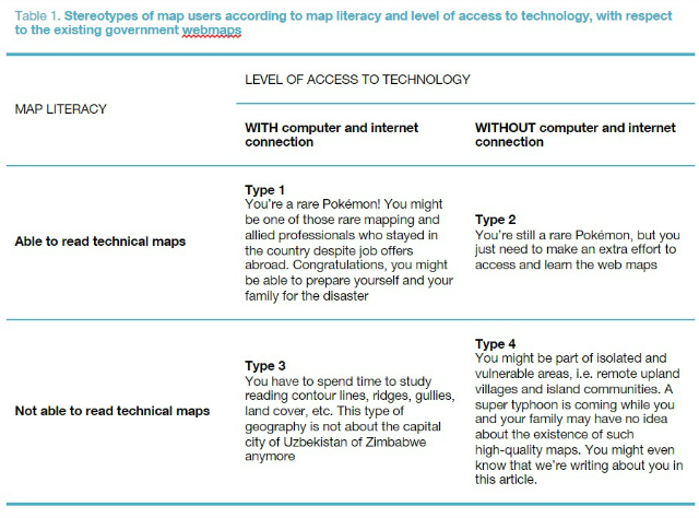
Table 1. Stereotypes of map users according to map literacy and level of access to technology, with respect to the existing government webmaps
If you’re part of Types 1 and 2, then you are a beneficiary of the government webmaps (geoportals). But if you belong to Types 3 and 4, then you are part of the overwhelming majority of Filipinos with low levels of access due to technical and technological barriers.
Because of data inaccessibility, the mapping projects produce outputs but fall short of their intended social outcomes because the data exists but is out of reach by the majority. Maybe, we have to write and send an official letter request first?
(2) The map data is in closed format
The data might be accessible, but it might be in closed format. Below is a quick comparison of “open” versus “closed” map data.
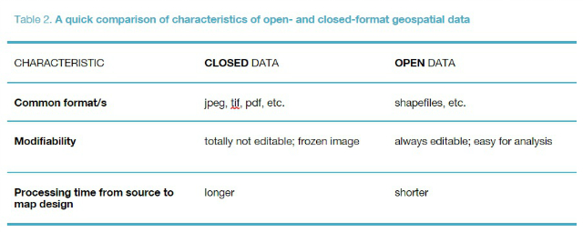
Table 2. A quick comparison of characteristics of open- and closed-format geospatial data
Presently, the majority of map data within existing government geoportals are available for the public, but in closed format.
With open data, skilled users are empowered to add value to this raw information. The analysis and design of maps is much faster. But with closed data, digital cartographers are forced to redo the maps just to make them appropriate for a general public audience. Large amounts of time are burned just to redo the maps.
Well-meaning though it may be, the government beaurocracy's unintended message to the public is:
“We really want these expensive maps and geoportals to help reduce disaster risk; mitigate climate change; spur national development; and so on; but to apply these data, you have to start from scratch. Here’s the jpeg and pdf; now spend days and weeks redrawing the shapes before you can actually design your map.”
And this is unfortunate.
What if geospatial data is open? Let’s have an example of what we’re missing out on.
Take, for example, if you need access to map data on previous earthquakes. Funnily enough, while it takes forever to get from our own government, there are foreign websites where you can directly access such data.
Hence, I was able to make this time-lapse map of earthquakes in the Philippines for the past 100 years using open data from USGS. You can view the map here: http://cdb.io/1Q1iCqt
All I had to do was to go to the USGS website, and with a few clicks I was able to download and plot the open-format geospatial data. It took me all of just five minutes.
(3) The map data is for sale
Finally, the geospatial data might be accessible and open, but it might be for sale. Again, understandably, this may be due to costs in personnel services, fieldwork, logistics, and digital processing. After all, the production of public geospatial data requires spending.
But it shouldn’t cost more than what it would take to print and burn an ordinary data CD.
In surprising contrast, when a city hall officer asks for the digital version of the geospatial data for planning the town and is charged at least Php 30,000.00 by the central government agency for the whole digital data set, is not such a government-to-government sale wryly funny?
And, in any case, weren’t these data sets funded using our hard-earned taxes? So why are such public maps treated as commodities?
We have to make a stand on such monopoly of public geospatial data that belongs to the national patrimony in the first place.
Reasons for the inaccessibility, closed format, and price of data
There are many popular—and superficially understandable—reasons for such “monopolies”.
First, there is fear of releasing data due to inaccuracy. Then, there are those who play the “national security” card: they’ll warn you against foreign and terrorist groups who can use such geospatial information. Finally, some mapping professionals in the government might feel an understandable sense of attachment to the data because of all the hard work they’ve put into producing the data set.
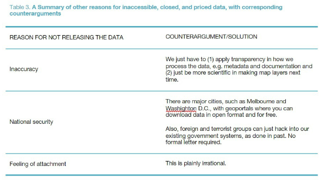
Table 3. A Summary of other reasons for inaccessible, closed, and priced data, with corresponding counterarguments
When map data is made accessible, open, and free by government
We can look at the story of Project NOAH for inspiration for the solution to the situation. For decades, other mapping agencies have always required letters, payments, and whatsoever red tape/excuse for not releasing data that belongs to the public and taxpayers. In contrast, what NOAH, despite not being the “official” mapping agency, did was to liberate the geospatial data by doing the following:
For those with access to technology: render the hard and soft copies of maps onto a webmap (and apps);
For those who can add value to the maps: release the open-format geospatial data (read: shapefiles) to professionals (mappers, planners, development workers, etc.) who need to serve the people through their work as soon as possible FOR FREE and without much formality; and
For the overwhelming majority of Filipinos with no access to technology and/or cannot read technical maps well: actually going to cities and municipalities to discuss, validate, and disseminate the maps in popular formats—even print them on canvas tarps, if you have to!
What the other agencies failed to do for decades, the NOAH team was able to accomplish in just a few years.
When map data is made accessible, open, and free by civil society
An excellent source of inspiration—and a concrete example of what's possible—is the work of the members of the Open Data Movement. A week before Super Typhoon Yolanda happened, the OpenStreetMap (OSM) team in the Philippines (Maning Sambale, Julius Bañgate, Eugene Villar, and others) organized map-a-thons with the global OSM community through its website (www.openstreetmap.org.ph).
The map-a-thons pulled thousands of digital volunteers from around the globe to trace the basic maps of Eastern Visayas, including Tacloban, before and after the storm hit.
Even while the strongest storm in history to make landfall barrelled its way through Eastern Visayas, thousands of hands were creating and updating accessible, open, and free map data.
Because the OSM data was more updated, for a time period these were the maps used by the majority of humanitarians instead of the standard government maps.
Back then, the existing and “official” topographic map sheet of Tacloban City didn’t even have a San Juanico Bridge drawn on it.
Open map data can reach people faster
Because Project NOAH and other geospatial data groups released the data in open formats (read: shapefile), we, humanitarians, were able to respond faster to the post-disaster situation. A number of open-data geoportals such as PhilGIS (Dr. Al Tongco, Robert Bugna, Cecil De Castro) already had basic and open map data for download in their website, www.philgis.org. Therefore, our mapping team (with Mikko Tamura, Ma. Mila Vela, and Jose Bernardo Gochoco III) spent less time than usual in reprocessing the maps; we had more time in fieldwork and community validation in Yolanda-hit communities, such as Suluan.
Suluan Island in Guiuan, Eastern Samar is the first island in the Philippines to be hit by Super Typhoon Yolanda. Reaching the island means taking a 3-hour boat ride through deep and open Pacific waters. The Suluanons do not have mobile phone signal, no internet connection, and no printer.
When our team arrived, it was the first time for Suluanons to see the maps.
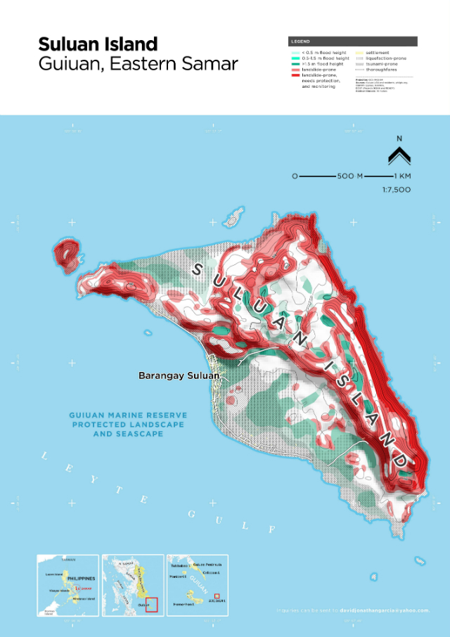
Figure 1. A geohazard map of Suluan. This is a work of the mapping team sponsored by UN-HABITAT, UNICEF, and the Local Government Unit of Guiuan, Eastern Samar. Data credits to OSM, DOST, DENR, JICA, OSM, PhilGIS, other data partners, and the people of Suluan.
Now, the people of Barangay Suluan in Guiuan, Eastern Samar have their own set of community-validated geohazard and base maps. They are now using it for evacuations and DRRM planning.
Even though they don’t have an Internet connection, they don’t have to go to a website. They don’t have to visit Fort Bonifacio, downtown Manila, Visayas Avenue, or C.P. Garcia Avenue just to get the map. They don’t even have to send an official letter for data request.
Through the efforts of Project NOAH, OSM, PhilGIS, and other data partners, we were able to bring the much-needed data to people who otherwise wouldn't have any access to these at all.
Again, the question arises: Why do we need a disaster for public map data to be released openly, freely, and without much formality?
Bakit kailangang mangyari muna ang trahedya bago ilabas ang datos?
A call to action
Our dear government mappers and data holders: you do not “own” the data. We all are but custodians, mere stewards, of the people’s data.
As such, it is our duty to release the data in the most accessible and open format, in the least possible cost and time.
And it is precisely because you put so much work into crafting those maps—risking life and limb in arduous fieldwork, even to the point of declining lucrative opportunities abroad—that the Filipino people deserve to see your work in their hands.
The matter is, quite simply, not just necessary but also a concern of national patrimony. As a basic human right, public geospatial data should be accessible, open, and free.
The gates to data demand to be opened.
David Garcia is a geographer and licensed urban, regional, and environmental planner. On mission for the Human Settlements Programme of the United Nations (UN-HABITAT), he made maps and plans in Guiuan, Ormoc, and Tacloban City for rehabilitation after Super Typhoon Yolanda. In addition, his current missions for the UN are in the cities of Iloilo, Silay, Cagayan De Oro, and Zamboanga for urban planning and design for sustainable urban development.
His opinions in this piece do not necessarily reflect the position of this website.
