

‘Handa’ website: 5 features that boost disaster preparedness
Facing an average of 20 tropical cyclones a year and located along the Pacific Ring of Fire, the Philippines remains highly vulnerable to natural hazards—making disaster preparedness crucial.
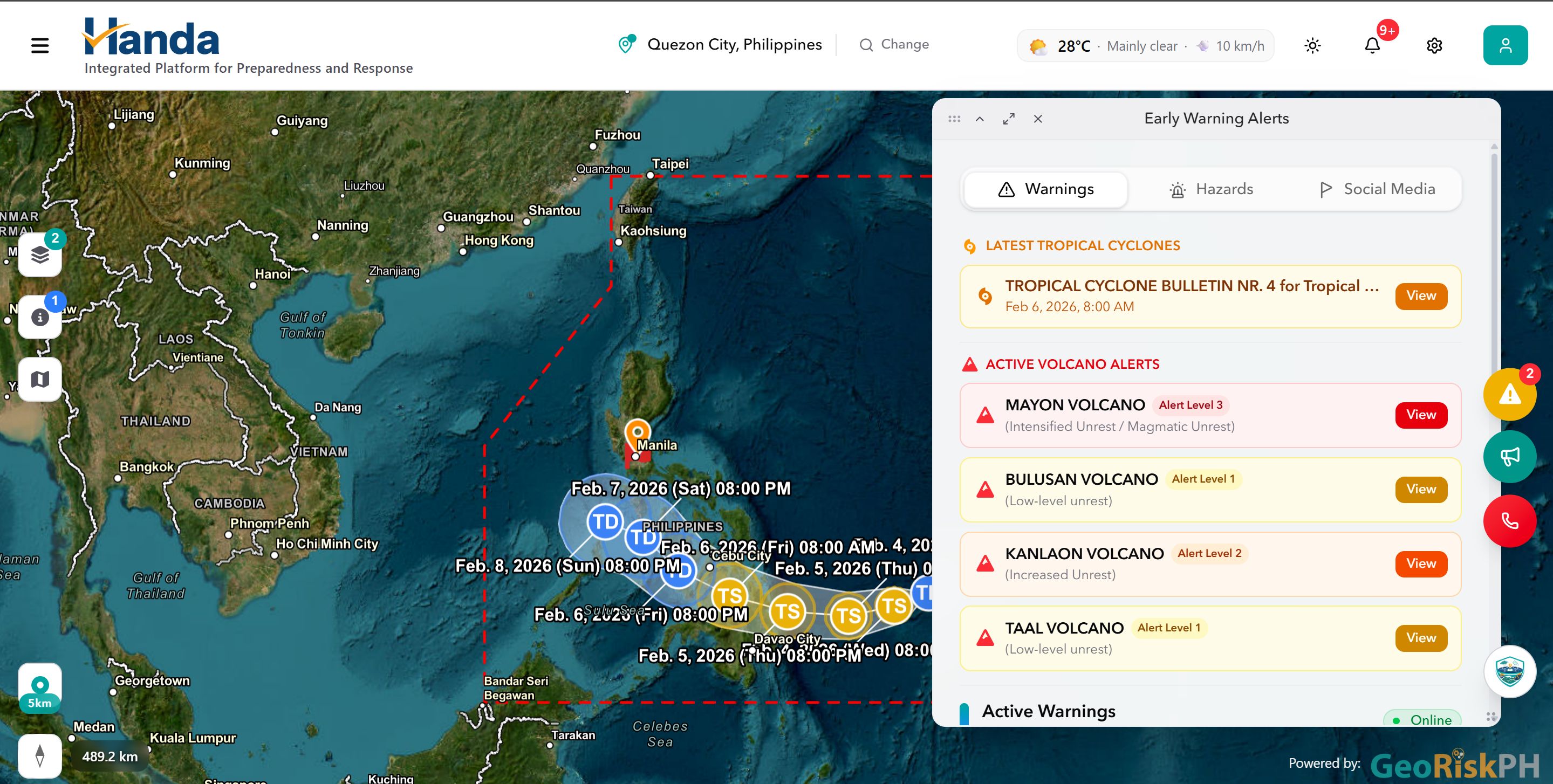
Through the Handa Integrated Platform for Preparedness and Response website, users can report incidents such as flooding, access near real-time updates, and share their locations with emergency responders in just a few clicks.
It is a unified platform powered by GeoRiskPH, a Philippine Institute of Volcanology and Seismology (PHIVOLCS)-led initiative that provides a centralized, web-based system for accessible hazard and risk data in the Philippines.
The Handa website uses geospatial data and artificial intelligence (AI) to deliver early warning information and analytics aimed at enhancing disaster preparedness, strengthening coordination, and building more resilient communities nationwide.
Led by the Department of Science and Technology (DOST) through PHIVOLCS, the Handa website was launched on Monday in Quezon City.
PHIVOLCS Director Dr. Teresito Bacolcol said the platform allows easier access to data from various government agencies.
“That is a science-based tool that can help decision-makers, local government units, and communities respond better to possible hazards and disasters,” Bacolcol said during his speech.
Meanwhile, DOST Secretary Renato Solidum described the Handa website as a platform that can transform data into action.
“Now that we have the technology, we must focus on what will make it truly effective—the human and institutional dimension,” Solidum said.
“Receiving a warning must translate into early prevention and early response,” he added.
Here are five features of the Handa website that can help users prepare for disasters:
1. Multi-hazard monitoring
Users can view timely alerts, advisories, and warnings from agencies such as PAGASA, PHIVOLCS, and the National Disaster Risk Reduction and Management Council (NDRRMC).
The Early Warning Alerts panel displays the latest tropical cyclone bulletins, active volcano alerts, flooding incidents, and assessments on seismic, volcanic, and hydro-meteorological hazards.
Users can also locate nearby evacuation centers and customize their location and search radius for more accurate alerts.
2. Reporting system
Users can report incidents by clicking the green icon and providing details such as the type of incident, description, location, and optional photos or videos.
Reports are verified by the Office of Civil Defense before appearing on the map as red markers.
Incidents that can be reported include flooding, fires, road accidents, and other emergencies. In urgent cases, users may use the Emergency Call (SOS) feature to access relevant hotlines.
3. AI assistant
The AI assistant provides location-based hazard, weather, and safety information.
It can identify nearby safe open spaces and offer insights to help users better understand risks and make informed decisions.
4. Event impact assessment
Users can monitor disasters such as typhoons, earthquakes, volcanic activity, and floods through interactive maps and alerts that show how events develop over time.
The platform also allows users to review both active and past disaster events.
5. National government agencies dashboard
For government use, Handa offers secure, role-based dashboards with integrated analytics, disaster tracking, and impact assessment tools.
These dashboards enable agencies to view consolidated data from multiple sources and access information tailored to their roles, improving coordination while ensuring data security and integrity.
Mabelline Cahulogan, PHIVOLCS supervising science research specialist, said agencies such as the Mines and Geosciences Bureau, Department of Education (DepEd), Department of Health (DOH), and the Department of Public Works and Highways (DPWH) contributed to the platform.
“We have the DOH and DPWH for critical facilities because these are needed for lifelines,” Cahulogan told GMA News Online.
“Alongside, we have granular data from different local government units,” she added.
GeoRiskPH is currently training LGUs to use a data collection tool for the platform and is planning to expand coordination with the private sector.—MCG, GMA Integrated News
