

How the Artemis II crew trained to observe and photograph the moon: A NASA science team geologist explains
The Artemis II crew has now broken the record — previously held by Apollo 13 — for the farthest distance any humans have ever travelled from Earth. The crew also completed a flyby of the moon’s far side and sent back some amazing images of the lunar surface.
I am a professor, an explorer and a planetary geologist, specializing in the study of meteorite impact structures. I am also a member of the First Artemis Lunar Surface Science Team and have been supporting NASA in developing the geology training for Artemis astronauts.
The flyby was particularly exciting as it offered a stunning new perspective of the lunar surface. It also provided the first operational test of a new science team and evaluation room at Mission Control in NASA’s Johnson Space Center in Houston, Texas.
And it was fantastic to see the Artemis II crew conduct observations and take photographs of geological landforms on the moon’s surface — putting their training with me at the Kamestastin Lake impact structure, on the territory of the Mushuau Innu First Nation in northern Labrador, into practice.
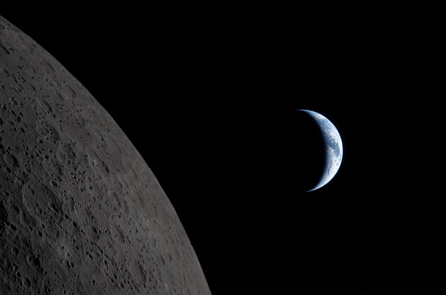
A new view of the moon
Unlike the Apollo missions, that orbited at approximately 110 kilometres above the surface of the moon, Artemis II was at a much higher altitude — around 6,545 kilometres above the lunar surface.
This greater distance allowed the crew to view the moon as a full disk, including regions near both the North Pole and South Pole.
The crew was also able to take targeted photographs of various geological landforms on the lunar surface as part of the Artemis II science program. One of the primary goals of these investigations is to inform future missions, including the planned first journey back to the lunar surface with Artemis IV as soon as 2028.
A new science team
One of the highlights of NASA’s livestream during the mission has been the direct conversations between two good friends: Canadian astronaut Jeremy Hansen and science officer Kelsey Young.
Science officers are the senior flight controllers responsible for lunar science and geology objectives during Artemis missions.
They act as the main interface between the wider Mission Control team and the Artemis II science team, which is located in a totally separate room called the Science Evaluation Room (SER).
Both science officers and the evaluation room are brand new for NASA’s Artemis program; they did not exist during the Apollo program.
We have been developing the structure and defining roles in the SER for the first Artemis mission to the moon’s surface. But there is nothing like a real mission to test and refine how the science team should work.
A crash course in lunar geology
If you listened in to NASA’s livestream and heard any of the geological descriptions the astronauts were giving, I hope you were impressed — I certainly was!
Their knowledge is a testament to the geology training that NASA has provided the crew in the months and years since they were selected for the Artemis program.
First, the crew participated in a crash course in lunar geology called “Lunar Fundamentals.” This weeklong, classroom-based training offered them the basics to understand lunar geology and the processes that shape the moon’s surface — primarily impact cratering and volcanism.
However, as somebody who has been teaching for more than 20 years, I know the best place to learn about geology is in the field. That’s why NASA also took the Artemis astronauts to a series of field sites in the United States, Iceland and Canada.
Early in their training, in September 2023, three of the crew members — Hansen, Christina Koch and back-up crew Jenni Gibbons — undertook geology training at the Kamestastin Lake impact structure in northern Labrador. Then the entire crew travelled to Iceland in August 2024.
Kamestastin Lake training expedition
I was honoured to play a leading role in the Kamestastin Lake training. This location was chosen because it offers a similar landscape to the surface of the moon.
The Kamestastin Lake crater was formed approximately 35 million years ago by the impact of an asteroid between one and two kilometres in diameter. Not only are rocks like breccias and impact melt rocks produced by the asteroid’s impact well preserved here, but the crater also formed in a rock called anorthosite — the exact same rock that makes up the lunar highlands.
In addition to participating in the geology training itself, I was largely responsible for the logistics for this expedition.
Kamestastin is in a remote part of northern Labrador, so we flew in via Twin Otter aircraft and established a temporary base camp. From tents to pots and pans and food for 16 people, there was a lot to take care of. We then used zodiac boats to travel around the crater.
Sacred Innu stories of the moon
Kamestastin Lake and the surrounding region are on the territory of the Mushuau Innu First Nation. A key part of my role in the training was liaising with the First Nation, which has been following Hansen on this historic mission.
A highlight for me was sitting around the fire on one of our last nights with Innu Guardians from Natuashish and hearing about how sacred the moon is to them — as it is to many Indigenous Peoples around the world.
They also told us the story of Tshakepesh, an Innu hero who teaches that with courage, hard work and perseverance, one can always overcome difficulties.
As the Artemis II crew return from its journey, I am struck by the parallels. The crew has shown the world what can happen if we work together towards a common goal with courage, hard work, perseverance and humility. —The Conversation via Reuters Connect
