

2025 tsunami in Alaska fjord was higher than Empire State Building, 2nd highest recorded
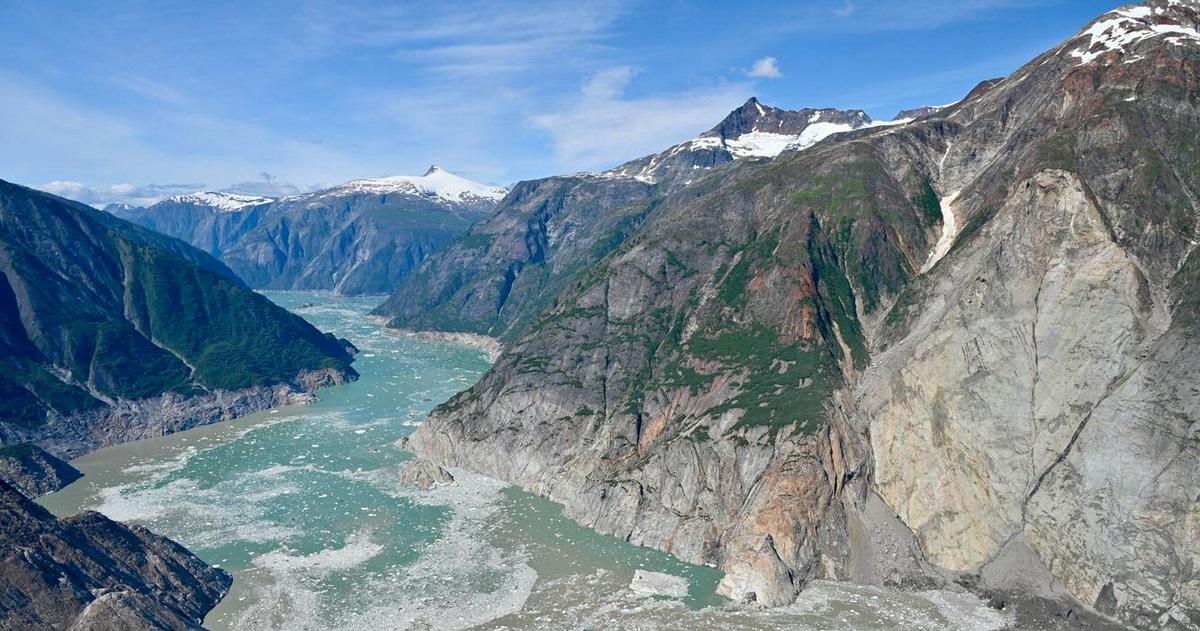
Tracy Arm Fjord, in southeastern Alaska within the Tongass National Forest, presents a majestic vista, with a narrow sea inlet surrounded by towering granite cliffs, waterfalls and glaciers. One morning last year it also was the site of a powerful landslide that triggered a huge localized tsunami.
Researchers have now determined that the tsunami on August 10, 2025, was the second-highest ever recorded, with a wave reaching up to 1,578 feet (481 meters) tall—higher than New York City's Empire State Building. The tsunami surged through the fjord, violently stripping vegetation from the steep rock walls.
The fjord has been a popular sightseeing destination, but because the tsunami occurred at 5:30 a.m., there were no cruise ships or other boats in the waterway and no one was hurt.
The researchers said the landslide was driven by climate change. The glacier buttressing the mountain had retreated amid warming temperatures, eventually leaving the rock unsupported.
"The fact that the landslide occurred this early in the morning was unbelievably lucky. Next time—and there will be a next time—we may not be so lucky," said University of Calgary geomorphologist Dan Shugar, lead author of the study published on Wednesday in the journal Science.

Such locations have been at the forefront of climate change impacts.
There were no photographs or video recordings of the tsunami, so the scientists reconstructed the events using aerial photos taken afterward, satellite and seismic data, fieldwork at the site and accounts of people who were nearby at the time.
Tracy Arm, about 50 miles (80 km) south of Alaska's capital Juneau, is roughly 25 miles (40 km) long and six-tenths of a mile (1 km) wide, with surrounding cliffs more than 3,280 feet (1,000 meters) high. The researchers determined the wave height by measuring where the stripping of vegetation had occurred, leaving dramatic scars on the rock walls. The wave rose so high because the immense volume of water displaced by rock from the landslide was squeezed through a confined space.
"The clearcut vegetation, like a bathtub ring around the fjord, is probably the most striking difference in how the fjord looks now versus last year, unless you were scuba diving and could see the massive deposit [of rock] on the ocean floor," Shugar said.
"The stripped vegetation is basically a very sharp line, below which there is only rock and sediment and some tree stumps, and above which is virgin forest, standing as it did on August 9 before the tsunami. Like two different worlds," Shugar said.
About 83 million cubic yards (64 million cubic meters) of rock collapsed in about one minute. That is 24 times the volume of the Great Pyramid of Giza, according to University College London geophysicist and study co-author Stephen Hicks.
"This collapse triggered a seismic wave observed around the globe," Hicks said.
Some waves became trapped in the fjord, causing what is called a seiche—sloshing of water—that lasted several days and created a distinct seismic wave, Hicks said. A similar landslide-generated tsunami at Greenland's Dickson Fjord in 2023 caused a wave about 650 feet (200 meters) tall and a seiche.
Tsunamis are giant waves caused by earthquakes or volcanic eruptions under the sea or landslides. The tallest tsunami on record—about 1,700 feet (520 meters)—also was a localized event, occurring in Alaska's Lituya Bay in 1958 following a landslide.
Tsunamis in the open ocean can travel vast distances and cause incredible coastal damage and loss of life. The 2004 quake-induced Indian Ocean tsunami, which killed some 230,000 people, had a recorded height of 167 feet (51 meters) in Sumatra. The 2011 quake-induced Japan tsunami, which killed more than 15,000 people, reached about 131 feet (40 meters).
"Tsunamis due to large earthquakes occur because a fault in the crust ruptures the seafloor, causing the vertical displacement of water above it. In the case of landslide events, it is the collapse of material from above the water and into the water that creates the wave," Hicks said.
The seismic data showed there actually were warning signs before the Tracy Arm landslide.
"With the benefit of hindsight, we have found that the landslide was preceded by about a week of tiny earthquakes indicating fracturing in the eventual landslide mass. This gives us possible hope of developing warning and forecasting systems, in tandem with other observations," Hicks said. — Reuters
