

Project DREAM uses new tech to map PHL flood-prone areas
On their maiden flight, two light planes took flight carrying instruments to map Philippine river basins and flood-prone areas. The University of the Philippines (UP) in partnership with the Department of Science and Technology (DOST) launched “Project DREAM” (or Disaster Risk and Exposure Assessment for Mitigation's LiDAR-equipped planes) on November 22, at Clark Air Base, in Angeles City, Pampanga. 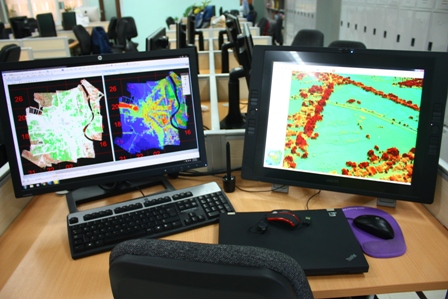 Two T-206 CESSNA planes equipped with LiDAR ALTM (Airborne Laser Terrain Mapper) Aquarius were commissioned to map at least 17 major river basins all over the country. These included the Marikina-Pasig River system and the Cagayan de Oro river. LiDAR ALTM costs around P200 thousand. The entire project costs around P1.6 billion, according to DOST. LiDAR technology, or Light Detection and Ranging, is a state-of-the-art surveying technology, similar to radars, that determines the range, height, and direction of objects. The instrument fires laser pulses on the surface it surveys at around 150,000 pulse per second. Its sensor measures the amount of time each pulse takes to bounce back and the LiDAR calculates the distance between itself and the target. LiDAR technology is capable of simultaneous land and water mapping through 3D imagery at a very rapid rate. It is also considered to be the most effective technique for flood hazard mapping.
