

Signal No. 1 up over Catanduanes as Quinta moves over Philippine Sea
Tropical Cyclone Wind Signal (TCWS) No. 1 was raised over Catanduanes on Saturday morning as Tropical Depression Quinta slightly accelerated while moving west-northwestward over the Philippine Sea.
In its 11 a.m. bulletin, PAGASA said winds of 30 to 60 kph may be expected in Catanduanes in at least 36 hours, or intermittent rains may be expected within 36 hours.
TCWS #1 may also be raised over Albay, Sorsogon, Northern Samar, and the eastern portion of Camarines Sur in the next bulletin, based on PAGASA's available meteorological data.
Batanes, Babuyan Islands, and the northern coastal areas of Ilocos Norte and mainland Cagayan, are also expected to experience strong to gale-force winds associated with a northeasterly surge.
Meanwhile, the troughs of both Tropical Depression Quinta and Severe Tropical Storm Saudel which is outside the Philippine Area of Responsibility (PAR) will bring light to moderate with at times heavy rains over MIMAROPA, Bicol Region, Visayas, Zamboanga Peninsula, Bangsamoro, Northern Mindanao, and Caraga.
Further, a stationary front currently extending over Extreme Northern Luzon associated with the northeasterly surge will bring moderate to heavy rains over Cagayan Valley and the northern portions of Apayao and Ilocos Norte.
Location, movement
As of 10 a.m. on Saturday, the center of Quinta was estimated based on all available data at 660 kms east of Catarman, Northern Samar or 730 km east of Juban, Sorsogon.
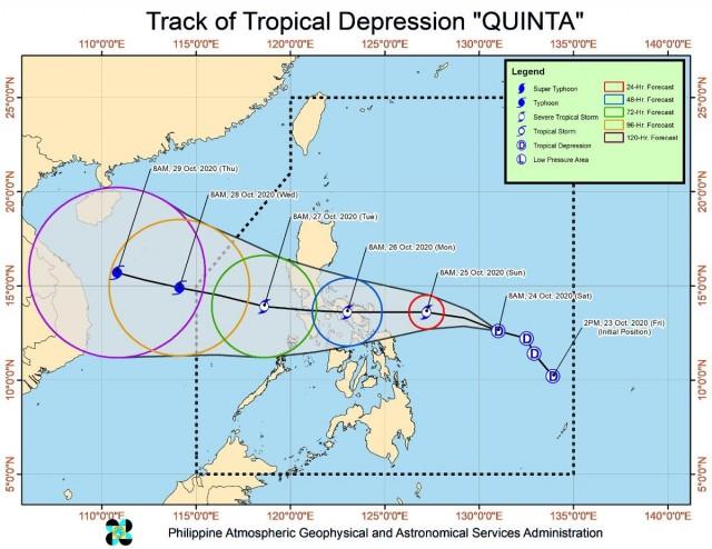
It is moving west-northwestward at 30 kph, with maximum sustained winds of 55 kph near the center and gustiness of up to 70 kph.
PAGASA said Quinta will move generally west-northwestward or northwestward this Saturday, then will turn westward on Sunday morning through Monday.
The weather bureau forecasted Quinta's center to make landfall over the Bicol Region between Sunday evening and Monday morning, then track westward over the Southern Luzon area on Monday.
Intensity
According to the weather bureau, Quinta is forecast to steadily intensify to tropical storm category within 12 hours, and may reach severe tropical storm category prior to landfall.
The tropical cyclone may continue intensifying over the West Philippine Sea after crossing the Philippine archipelago.
Hazards on coastal waters
A gale warning was issued over the seaboards of Northern Luzon, the western seaboards of Central Luzon, Batangas, Occidental Mindoro, and northern Palawan including Calamian and Kalayaan Islands due to rough to very rough seas (2.8 to 6.0 m).
Sea travel will be risky over the said areas, especially for small seacraft.
Moderate to rough seas (1.5 to 2.5 m) will meanwhile prevail over the western seaboard of southern Palawan and the eastern seaboards of Central and Southern Luzon.
PAGASA said mariners of small seacraft are advised to take precautionary measures when venturing out to sea, while inexperienced mariners should avoid navigating in these conditions.
Meanwhile, the center of Severe Tropical Storm "Saudel" outside the PAR was estimated based on all available data at 805 kms west of Northern Luzon as of 10 a.m.
Saudel has maximum sustained winds of 110 kph near the center and gustiness of up to 135 kph, and is moving west-northwestward at 10 kph heading towards the central portion of Vietnam. —Jamil Santos/KG, GMA News
