

Signal no. 3 raised over Catanduanes as Rolly maintains strength as it moves toward Bicol
Tropical Cyclone Wind Signal No. 3 was raised over Catanduanes at 11 a.m. on Saturday as Typhoon Rolly maintained its strength while moving west-southwestward towards the Bicol Region.
In its severe weather bulletin, PAGASA said Catanduanes may experience winds greater than 121 kph up to 170 kph in at least 18 hours.
Tropical Cyclone Wind Signal No. 2 was also raised in the following areas:
Luzon:
• The central and southern portions of Quezon (Mauban, Sampaloc, Lucban, Candelaria, Dolores, Tiaong, San Antonio, Sariaya, Tayabas City, Lucena City, Pagbilao, Atimonan, Padre Burgos, Agdangan, Unisan, Plaridel, Gumaca, Pitogo, Macalelon, General Luna, Catanauan, Mulanay, San Francisco, San Andres, San Narciso, Buenavista, Lopez, Calauag, Guinayangan, Tagkawayan, Quezon, Alabat, Perez) including Polillo Islands
• Camarines Norte
• Camarines Sur
• Albay
• Sorsogon
• Burias and Ticao Islands
• Marinduque
Visayas:
• Northern Samar
Eye
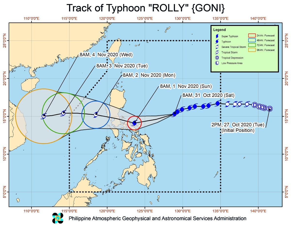
PAGASA said the center or eye of Typhoon Rolly is forecast to pass very close to Catanduanes, the Calaguas Islands, and very close to mainland Camarines Provinces on Sunday morning, and over Polillo Islands and mainland Quezon on Sunday afternoon.
It added that it is not ruling out a landfall scenario over Catanduanes and Camarines Provinces due to the proximity of the forecast track to Bicol Region.
Catanduanes, Camarines Norte, and the northern portion of Camarines Sur are seen to experience violent winds and intense rainfall associated with the inner rainband-eyewall region on Sunday early morning through afternoon and over Quezon and the southern portion of Aurora in the afternoon through evening.
After crossing Central Luzon, the center of Rolly is forecast to exit the mainland Luzon landmass on Monday morning, the state weather bureau added.
Rainfall
Starting Sunday early morning, PAGASA said Metro Manila, Bicol Region, CALABARZON, Central Luzon, Marinduque, and the northern portions of Occidental Mindoro and Oriental Mindoro will experience heavy to intense rains.
Cagayan Valley, Cordillera Administrative Region, Ilocos Region, Romblon, and the rest of Occidental Mindoro and Oriental Mindoro will meanwhile experience moderate to heavy rains
Flooding (including flash floods), rain-induced landslides, and sediment-laden streamflows) may occur during heavy or prolonged rainfall especially in areas that are highly or very highly susceptible to the hazards.
Strong winds
Those areas under TCWS No. 3 will experience destructive typhoon-force winds; those under TCWS No. 2 will experience damaging gale-to storm-force winds; and those under TCWS No. 1 will experience strong breeze to near gale conditions
Elsewhere, PAGASA said strong breeze to near gale conditions due to the northeasterlies will be experienced over Batanes, Babuyan Islands, Ilocos Norte, Apayao, and the coastal and mountainous areas of Cagayan and Isabela (that are not under TCWS no. 1).
Storm surge
The northern coastal areas of Quezon, including Polillo Islands have a moderate to high risk of storm surge of up to 3.0 meters.
Up to 2.0 m storm surge meanwhile, may occur over the coastal areas of Aurora, Marinduque, Bicol Region, and Northern Samar and the other coastal areas of Quezon in the next 48 hours.
PAGASA said this may result in life-threatening and damaging coastal inundation, accompanied by swells and breaking waves reaching the coast.
Location and movement
As of 10 a.m. on Saturday, Typhoon Rolly was located based on all available data at 480 km east northeast of Virac, Catanduanes.
It is moving west southwestward at 20 kph with maximum sustained winds of 215 kph near the center and gustiness of up to 265 kph.
Intensity
PAGASA said Rolly is likely to remain a typhoon category (185-205 kph) by the time it grazes Bicol Region and makes landfall over Quezon.
As it traverses over Luzon, Rolly is forecast to weaken considerably and emerge as a severe tropical storm or minimal typhoon over the West Philippine Sea.
PAGASA advised residents to take the necessary precautions. —KG, GMA News
