

Ulysses slows down, Signal No. 1 over 10 areas
Tropical Storm Ulysses has slowed down while moving in the northwest direction, according to the Severe Weather Bulletin posted by PAGASA.
In anticipation of the onset of strong breeze to near gale conditions associated with Ulysses, Tropical Cyclone Wind Signal (TCWS) No. 1 is now in effect over more localities in CALABARZON, Bicol Region, and Eastern Visayas. More areas in these regions will be placed under TCWS No. 1 in the next bulletin.
Meanwhile, TCWS No. 2 may be hoisted in some areas of Bicol Region as early as tonight. Based on the intensity forecast, the highest wind signal to be hoisted during the passage of Ulysses will be TCWS No. 3.
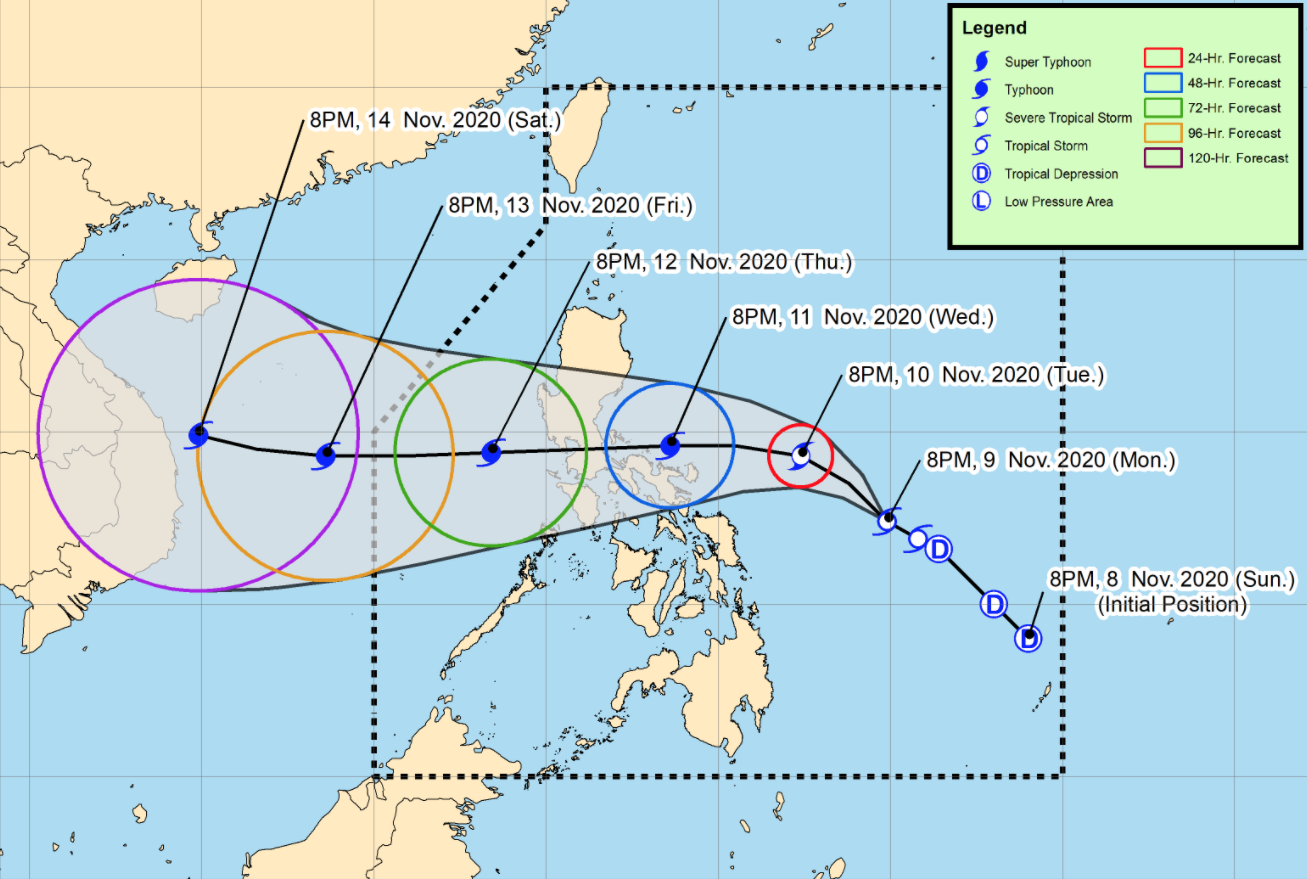
Ulysses is forecast to intensity into a severe tropical storm on Tuesday evening. Owing to favorable conditions, this storm may reach typhoon category by Wednesday morning and reach its peak intensity (140-155 kilometers per hour) tomorrow afternoon or evening. Landfall at or near peak intensity is highly likely.
As of 4 a.m. on Tuesday, the center of Tropical Storm Ulysses was estimated at 555 kilometers east of Virac, Catanduanes with maximum sustained winds of 65 kilometers per hour near the center and gustiness of up to 80 kph and moving northwestward slowly.
Tropical Cyclone Wind Signal (TCWS) No. 1 is hoisted over the following areas:
Luzon
- Catanduanes
- Camarines Norte
- Camarines Sur
- Albay
- Sorsogon
- the eastern portion of Masbate (Aroroy, Pio V. Corpuz, Cataingan, Palanas, Uson, Dimasalang, Masbate City, Mobo, Baleno) including Ticao and Burias Islands
- the southeastern portion of Quezon (Guinayangan, Tagkawayan, Buenavista, San Andres, San Narciso)
Visayas
- Northern Samar
- the northern portion of Samar (Santo Nino, Almagro, Tagapul-An, Tarangnan, Calbayog City, Santa Margarita, Gandara, Pagsanghan, San Jorge, San Jose de Buan, Matuguinao)
- the northern portion of Eastern Samar (Maslog, Dolores, Oras, San Policarpo, Arteche, Jipapad)
On Tuesday, the tail-end of a cold front (shear line) will bring light to moderate with at times heavy rains over Cagayan including Babuyan Islands, Isabela, and Apayao.
Light to moderate with at times heavy rains due to Ulysses will also be experienced over Aurora, Quezon, Bicol Region, Eastern Visayas, Caraga, and Davao Region.
Moderate to heavy rains associated with the rainbands of the tropical storm will begin affecting Bicol Region and portions of Eastern Visayas on Wednesday.
Flooding (including flashfloods), rain-induced landslides, and sediment-laden streamflows such as lahar may occur during heavy or prolonged rainfall especially in areas that are highly or very highly susceptible to these hazards and/or those that received significant antecedent rainfall.
Hazards affecting coastal waters
In the next 24 hours, rough to very rough seas (from 2.5 to 5.0 meters) will be experienced over the entire seaboards of Northern Luzon and the seaboards of Kalayaan Islands due to the surge of the Northeast Monsoon.
Tropical Storm Ulysses will also bring rough to very rough seas (2.5 to 4.5 meters) over the seaboards of areas under TCWS, Aurora, and northern Quezon (including the northern and eastern coastal waters of Polillo Islands) and the eastern seaboard of Eastern Samar (that are not under TCWS).
Sea travel is risky over these waters, especially for mariners of small seacrafts.
Moderate to rough seas will be experienced over the western seaboards of Central and Southern Luzon and the eastern seaboard of Mindanao. Mariners of small seacrafts are advised to take precautionary measures when venturing out to sea. Inexperienced mariners should avoid navigating in these conditions
On the forecast track, Tropical Storm Ulysses will move generally northwestward today, then turn more westward tomorrow.
On the forecast track, the center of Ulysses is more likely to make landfall over Quezon on Thursday morning, with a close approach of Catanduanes and Camarines Norte tomorrow afternoon and evening, respectively. However, the slight shift in the orientation of the track forecast shows an increasing likelihood of landfall over Bicol Region tomorrow afternoon or evening.
