

Signal No. 3 up over 12 areas as Ulysses now a typhoon
Tropical Cyclone Wind Signal No. 3 was raised over 12 areas in the country due to Ulysses, which has intensified into a typhoon on Wednesday, according to state weather bureau PAGASA.
In its 11 a.m. bulletin, PAGASA said the following areas are under Signal No. 3:
- southern portion of Aurora (Dipaculao, Baler, Maria Aurora, San Luis, Dingalan)
- southern portion of Nueva Ecija (Bongabon, Gabaldon, General Tinio, Laur, Palayan City, Cabanatuan City, Santa Rosa, Peñaranda, Gapan City, San Leonardo, Jaen, San Antonio, San Isidro, Cabiao)
- eastern portion of Pampanga (Candaba, Arayat, Santa Ana, Mexico, San Luis, San Simon, San Fernando City, Santo Tomas, Apalit, Minalin, Bacolor, Santa Rita, Guagua, Macabebe, Masantol, Sasmuan, Lubao),
- Bulacan
- Metro Manila
- Cavite
- Laguna
- Rizal
- northern and central portions of Quezon (General Nakar, Infanta, Real, Mauban, Sampaloc, Lucban, Tayabas City, Sariaya, Candelaria, Dolores, Tiaong, San Antonio, Lucena City, Pagbilao, Atimonan, Padre Burgos, Unisan, Agdangan, Gumaca, Plaridel, Pitogo, Macalelon, Lopez, General Luna, Catanauan, Buenavista, Guinayangan, Tagkawayan, Calauag, Quezon, Alabat, Perez) including Polillo Islands
- Catanduanes
- Camarines Norte
- northern portion of Camarines Sur (Del Gallego, Ragay, Lupi, Sipocot, Cabusao, Bombon, Calabanga, Tinambac, Siruma, Goa, Lagonoy, San Jose, Garchitorena, Presentacion, Caramoan)
Signal No. 2, meanwhile, was raised over the following areas:
- central and southern portions of Quirino (Maddela, Cabarroguis, Aglipay, Nagtipunan)
- central and southern portions of Nueva Vizcaya (Kasibu, Bambang, Kayapa, Dupax Del Norte, Dupax Del Sur, Aritao, Santa Fe, Alfonso Castaneda)
- southern portion of Benguet (Bokod, Itogon, Tublay, La Trinidad, Sablan, Baguio City, Tuba)
- southern portion of La Union (Burgos, Naguilian, Bauang, Caba, Aringay, Tubao, Pugo, Santo Tomas, Rosario, Agoo)
- Pangasinan
- Zambales
- Bataan
- Tarlac
- the rest of Pampanga
- the rest of Nueva Ecija
- the rest of Aurora
- Batangas
- the rest of Quezon
- Marinduque,
- northern portion of Occidental Mindoro (Paluan, Abra de Ilog) including Lubang Island
- northern portion of Oriental Mindoro (Pola, Victoria, Naujan, Baco, Calapan City, San Teodoro, Puerto Galera)
- the rest of Camarines Sur
- Albay
- Sorsogon
- Burias and Ticao Islands
The following areas, meanwhile, re under Signal No. 1
- Isabela
- the rest of Quirino
- the rest of Nueva Vizcaya
- Kalinga
- Mountain Province
- Ifugao
- the rest of Benguet
- Abra
- Ilocos Sur
- the rest of La Union
- the rest of Occidental Mindoro
- the rest of Oriental Mindoro
- Romblon
- the rest of Masbate
- Northern Samar
- northern portion of Samar (Santo Nino, Almagro, Tagapul-An, Tarangnan, Calbayog City, Santa Margarita, Gandara, Pagsanghan, San Jorge, San Jose de Buan, Matuguinao)
- northern portion of Eastern Samar (Maslog, Dolores, Oras, San Policarpo, Arteche, Jipapad)
The Department of the Interior and Local Government (DILG) has reminded localities, especially those in Bicol region and nearby areas, to implement the necessary protocols in preparation for Ulysses.
As a precaution, preemptive evacuations have already been done in several communities in Camarines Norte and the island province of Catanduanes, which bore the brunt of Super Typhoon Rolly.
The threat of Ulysses also prompted several local government units to cancel classes for the day.
Destructive winds, torrential rainfall
PAGASA said destructive winds and intense with at times torrential rainfall are expected over the northern portions of Catanduanes, Camarines Sur, and Camarines Norte until Wednesday evening.
The same condition will be experienced over Aurora and the northern portion of Quezon starting Wednesday evening through Thursday morning, it added.
Ulysses will move westward and cross the seas at the north of Catanduanes between Wednesday morning and afternoon, then at the north of Camarines provinces between on Wednesday afternoon and evening.
PAGASA is seen to make landfall over Polillo Islands and mainland Quezon between Wednesday evening and Thursday morning.
After landfall, the typhoon will cross Central Luzon and emerge over the western seaboard of Zambales between Thursday morning and afternoon
“It is likely to remain a typhoon throughout its traverse,” PAGASA said.
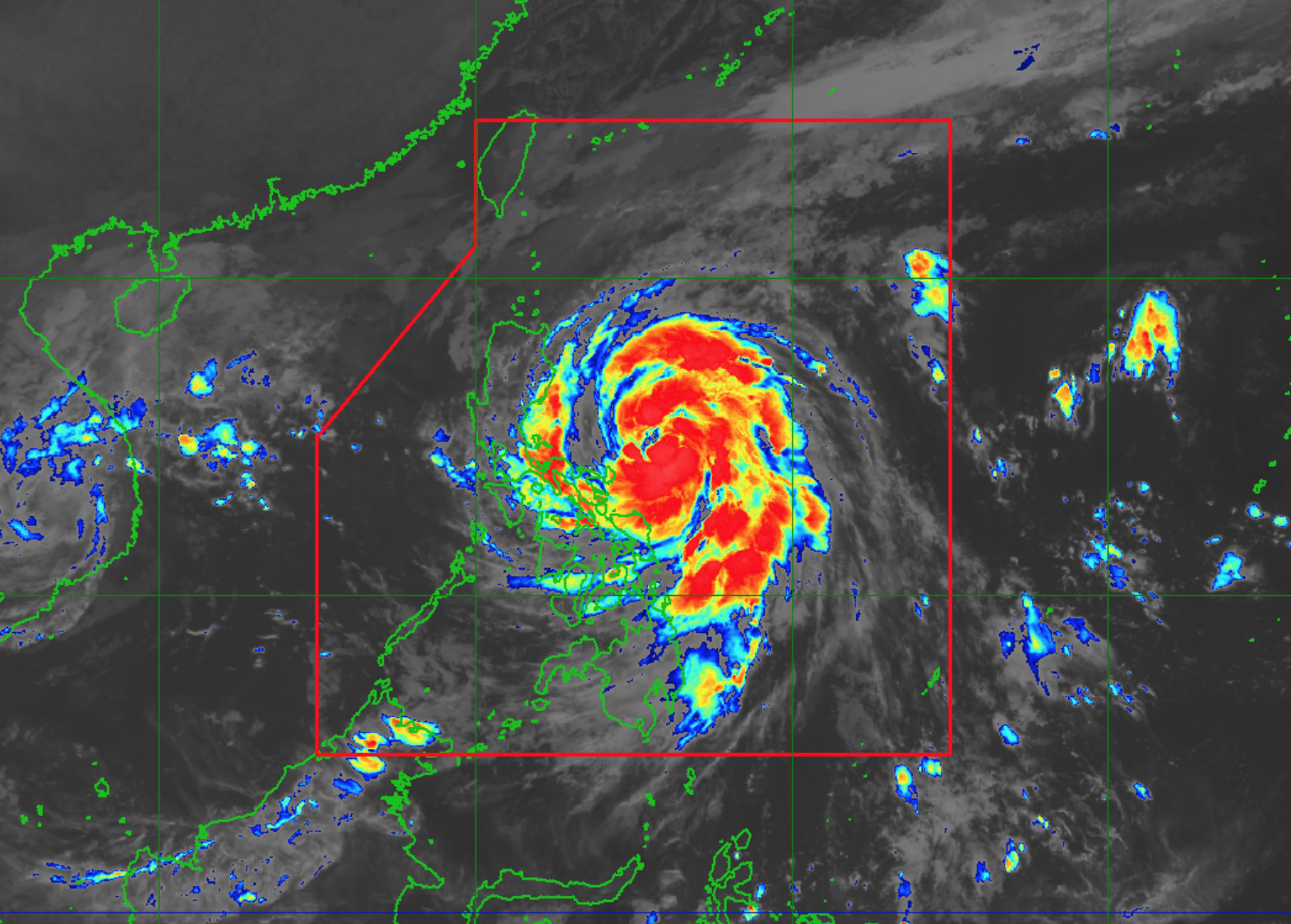
At 10 a.m., Ulysses was located at 100 kilometers North of Virac, Catanduanes with maximum sustained winds of 125 km per hour and gustiness of up to 155 km/h.
It is moving West Northwestward at 20 km/h.
Forecast
Heavy to intense with at times torrential rains are expected over Camarines Norte, Camarines Sur, and Catanduanes until the evening, according to PAGASA.
Moderate to heavy with at times intense rains can be experienced over Albay, Sorsogon, Quezon including Polillo Islands, and Burias and Ticao Islands.
Metro Manila and the rest of Luzon and Visayas will have light to moderate with at times heavy rains.
PAGASA warned of possible flooding including flash floods, rain-induced landslides, and sediment-laden streamflows like lahar during heavy or prolonged rainfall in areas prone to these hazards.
These hazards can also be encountered in areas that received significant antecedent rainfall.
Storm surge up to 3.0 meters high can happen over the coastal areas of Quezon including Polillo Islands, Camarines Norte, Catanduanes, and the northern and eastern coastal areas of Camarines Sur,
Up to 2.0 m of storm surge is also possible over the coastal areas of La Union, Pangasinan, Isabela, Zambales, Aurora, Bataan, Pampanga, Bulacan, Metro Manila, Cavite, Batangas, northern portions of Mindoro Provinces including Lubang Island, Marinduque, Romblon, Masbate including Ticao and Burias Islands, Albay, and Sorsogon, and the remaining coastal areas of Camarines Sur.
“These storm surges, which may be accompanied by swells and/or breaking waves near the coast, can cause life-threatening and damaging coastal inundation,” PAGASA warned.
A moderate risk of storm surge is also possible over the coastal areas surrounding Laguna de Bay.
Rough to very high seas of up to 10.0 m are expected over the seaboards of areas under TCWS and the eastern seaboard of Eastern Samar within the next 24 hours.
Due to the surge of the Northeast Monsoon, rough to high seas of up to 6.0 m can be experienced over the remaining seaboards of Northern Luzon.
The seaboards of Kalayaan Islands will have rough seas of up to 3.5 m.
“Sea travel is risky for all types of seacrafts over these waters,” PAGASA warned.
Moderate to rough seas of up to 2.5 m are expected over the western seaboards of Palawan including Calamian Islands, and the eastern seaboards of Mindanao.
“Mariners of small seacrafts are advised to take precautionary measures when venturing out to sea. Inexperienced mariners should avoid navigating in these conditions,” PAGASA said. --KBK, GMA News
