

Ulysses exits PAR, reintensifies into typhoon, leaves wind gusts in wake
Ulysses, now outside the Philippine Area of Responsibility (PAR), re-intensified into a typhoon, leaving gusty winds merging with the Northeast Monsoon wind flow over some parts of Luzon, PAGASA said Friday.
In its 11 a.m. update, PAGASA reported that both Ulysses and the Northeast Monsoon will continue to bring gusty conditions over Batanes, Babuyan Islands, Cordillera Administrative Region, Ilocos Region, Zambales, and Bataan.
Moderate to heavy rainfall are expected over Batanes and Babuyan Islands, while light to moderate with at times heavy rains may prevail over the rest of Cagayan Valley, Cordillera Administrative Region, Ilocos Norte, and Aurora, the state weather bureau added.
Likewise, it warned that flooding (including flash floods), rain-induced landslides, and sediment-laden stream flows (lahar) may occur during heavy or prolonged rainfall, especially in areas that are highly or very highly susceptible to the hazards or those that got significant antecedent rainfall.
No Tropical Cyclone Wind Signal has been raised in any part of the country, PAGASA said.
Coastal waters hazards
PAGASA said that within the next 24 hours, the combined effects of Ulysses and the surge of the Northeast Monsoon will bring rough to very rough seas (2.5 to 5.5 meters high) over the seaboards of Batanes, Babuyan Islands, Ilocos Norte, Ilocos Sur, La Union, Pangasinan, and Zambales; the northern seaboard of mainland Cagayan, and the western seaboards of Bataan, Batangas, Occidental Mindoro (including Lubang Island), and Palawan (including Calamian and Kalayaan Islands)
Sea travel will be risky for all types of sea crafts in these waters.
Moderate to rough seas (2.0 to 3.5 m) will meanwhile be experienced over the eastern seaboards of Luzon.
Mariners of small sea crafts are advised to take precautionary measures when venturing out into the sea, and inexperienced mariners should avoid navigating in the said conditions.
Track, intensity outlook
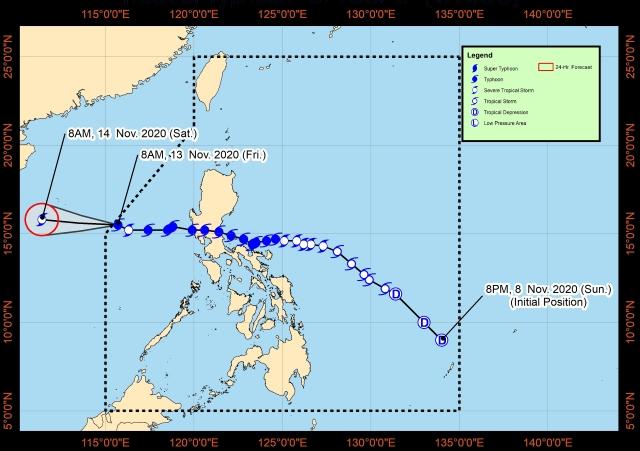
The center of the eye of Ulysses exited PAR at 9:30 a.m. on Friday.
Ulysses, which is forecast to move generally westwards or west-northwestward toward the central portion of Vietnam, re-intensified into a typhoon at 8 a.m.
PAGASA said the typhoon will likely maintain its strength in the next 12 hours, then gradual weakening is expected due to increasingly unfavorable conditions caused by the surge of the Northeast Monsoon.
As of 10 a.m., the center of the eye of Typhoon Ulysses was located based on all available data at 500 km west of Iba, Zambales.
It is moving west-northwestwards at 10 kph, with maximum sustained winds of 120 kph near the center and gustiness of up to 150 kph. —LBG, GMA News
