

Signal No. 1 up over Kalayaan Islands as Vicky approaches
Tropical Cyclone Wind Signal No. 1 remains hoisted over Kalayaan Islands in Palawan on Sunday morning as Tropical Depression Vicky approaches the area, PAGASA said in its 5 a.m. severe weather bulletin.
The islands will experience strong breeze to near gale conditions (30-60 km/h) due to Vicky.
Meanwhile, most of Luzon, especially coastal and mountainous areas, will likely have gusty conditions due to the surge of the Northeast Monsoon (Amihan).
Rainfall
Moderate to heavy rains which may be intense at times will be experienced over mainland Cagayan Valley, Apayao, Kalinga, Mountain Province, Ifugao, Aurora, Quezon, Bicol Region, and Kalayaan Islands due to Vicky and the tail-end of a frontal system (Shear Line).
Light to moderate and at times heavy rains meanwhile will be felt over Babuyan Islands, Metro Manila, the rest of Cordillera Administrative Region (CAR), Central Luzon, Calabarzon, and MIMAROPA.
On Sunday, moderate to heavy rains are to be expected over Babuyan Islands, mainland Cagayan Valley, Aurora, Apayao, Kalinga, Mountain Province, and Ifugao; and light to moderate with at times heavy rains over Batanes, Kalayaan Islands, and the rest of CAR.
Flooding
PAGASA warned of flooding, including flash floods, and rain-induced landslides in areas prone to these hazards, as well as in localities that received significant antecedent rainfall recently.
River channels may swell, causing flooding in adjacent or nearby areas.
Coastal waters
Due to the monsoon and Vicky, coastal waters will be:
- rough to high seas (up to 6 meters) over the entire seaboards of Northern Luzon;
- rough to very rough (up to 5 meters) over the seaboard of Zambales, the western seaboard of Bataan, the seaboard of Lubang Island, the western seaboard of Palawan including Calamian and Kalayaan Islands, the seaboard of Aurora, the eastern seaboard of Quezon including Polillo Islands, the seaboard of Camarines Norte, the northern seaboard of Camarines Norte, the northern and eastern seaboards of Catanduanes, the eastern seaboard of Albay including Rapu-Rapu Islands, the eastern seaboard of Sorsogon, and the northern and eastern seaboards of Northern Samar;
- moderate to rough (up to 3.5 meters) over the western seaboard of Batangas, the western seaboard of Occidental Mindoro, eastern seaboard of Eastern Samar including Homonhon Island, the eastern seaboard of Dinagat Islands, the eastern seaboard of Surigao del Norte including Siargao and Bucas Grande Islands, and the eastern seaboard of Surigao del Sur.
Sea travel is risky over these areas.
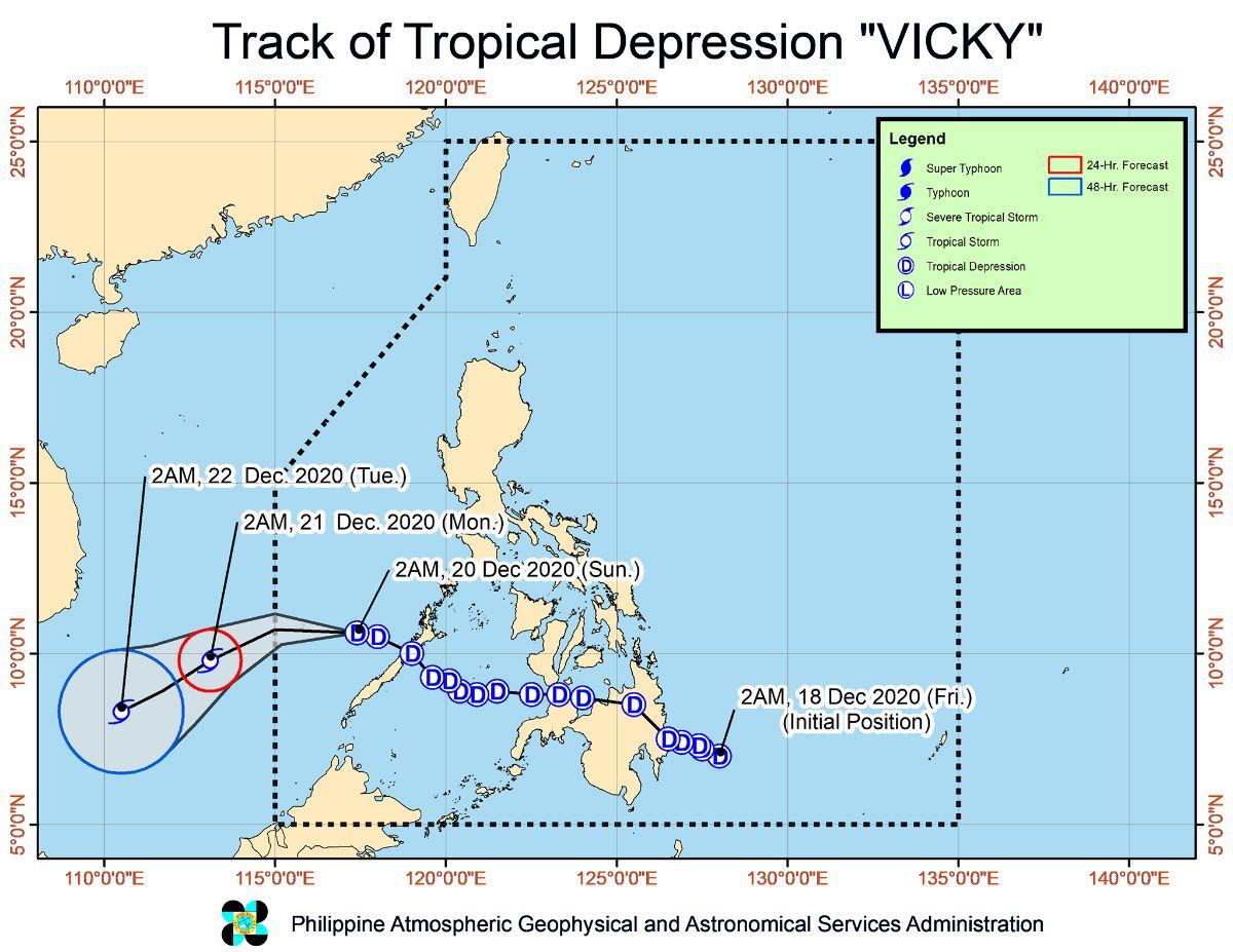
Location and track
At 4 a.m., the eye of Vicky was located at 195 km west northwest of Puerto Princesa City, Palawan or 340 km east of Kalayaan Islands.
It is moving west northwestward at 25 km/h.
Vicky has maximum sustained winds of 55 km/h near the center and gustiness of up to 70 km/h.
In the next 12 hours, Vicky is expected to move west-northwestward over the West Philippine Sea and exit the Philippine Area of Responsibility on Sunday afternoon or evening.
PAGASA advised the public and disaster risk reduction and management council concerned to take the appropriate action and await the 11 a.m. severe weather bulletin. —KG, GMA News
