

Fabian to enhance southwest monsoon, bring scattered rains over parts of southern Luzon
Tropical Depression Fabian is unlikely to bring heavy rainfall in the country throughout the forecast period but is currently enhancing the southwest monsoon, according to the latest Severe Weather Bulletin posted by PAGASA.
The weather bureau reported that MIMAROPA, Bicol Region, Visayas, Zamboanga Peninsula, Zambales, Bataan, Tawi-Tawi, Sulu, and Basilan will have cloudy skies with scattered rainshowers and thunderstorms due to the southwest monsoon with possible flash floods or landslides during moderate to at times heavy rains.
Metro Manila and the rest of the country will have partly cloudy to cloudy skies with rainshowers or thunderstorms due to southwest monsoon / localized thunderstorms with possible flash floods or landslides during severe thunderstorms.
Forecast wind and coastal water conditions
Southern Luzon and Visayas will experience moderate to strong wind speed moving southwestward while coastal waters will be moderate to strong.
The rest of Luzon will experience light to moderate wind speed moving in the southwest to south direction while coastal waters will be slight to moderate.
Wind speed forecast in Mindanao is light to moderate moving southwestward while coastal waters will be slight to moderate.
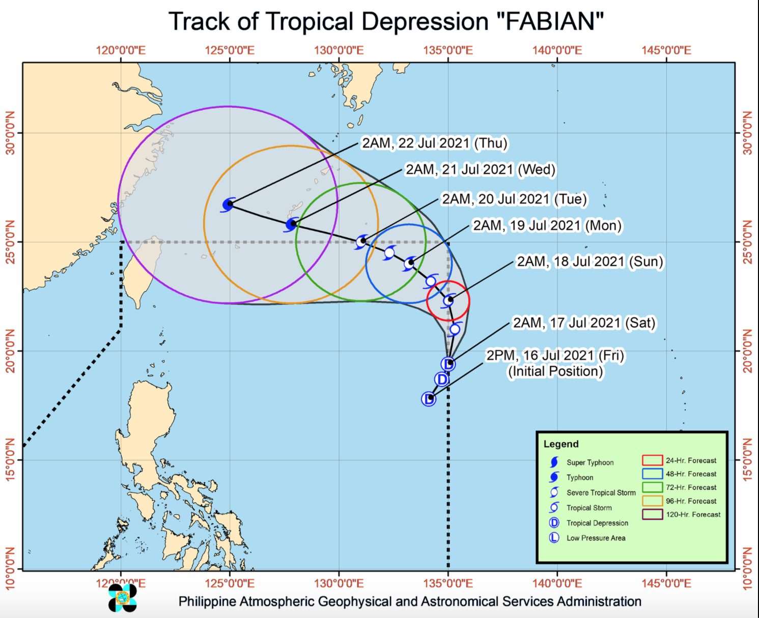
The center of Tropical Depression Fabian was estimated at 1,365 kilometers east of extreme northern Luzon with maximum sustained winds of 55 kilometers per hour near the center, gustiness of up to 70 kph, and central pressure of 1002 hPa.
Fabian is moving north northeastward at a speed of 15 kph with strong winds extending outwards up to 200 kilometers from the center.
PAGASA also reported that no Tropical Cyclone Wind Signal is currently in effect.
Fabian will remain far from the Philippine landmass throughout the forecast period and is forecast to move northward or north northwestward until early Sunday morning.
Fabian may be outside the PAR for a brief period and after re-entering the PAR, will move northwestward or west northwestward until the end of the
forecast period and exit the PAR between Monday evening and
Tuesday morning while moving towards the southern portion of the Ryukyu Islands.
PAGASA adds that Fabian may reach tropical storm category within 12 hours and further develop into a typhoon by Wednesday evening or Thursday morning.
