

Paeng slightly intensifies; Signal No. 2 raised over six areas
Tropical Storm Paeng slightly intensified while moving west northwestward over the Philippine Sea, with Signal No. 2 raised over six areas, according to PAGASA's tropical cyclone update early Friday morning.
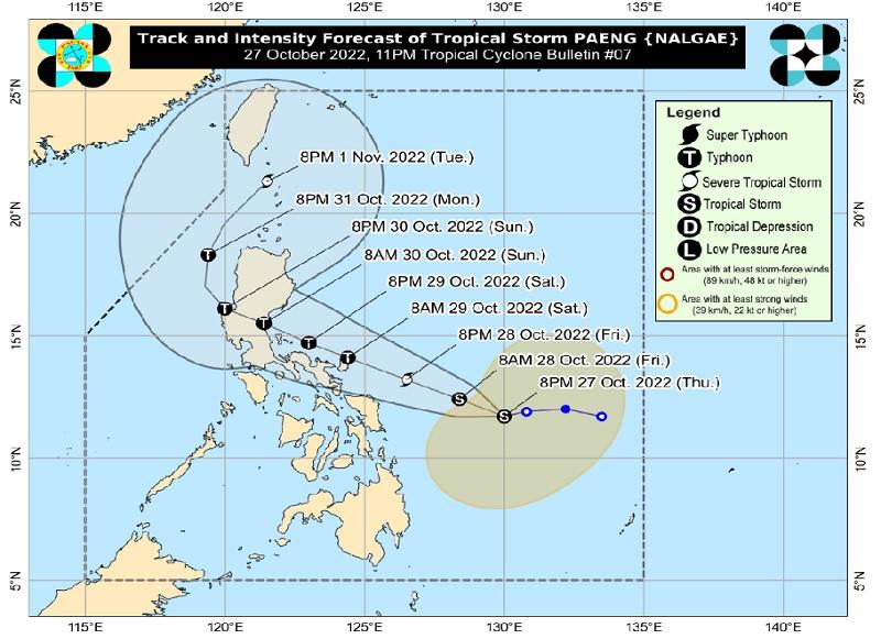
The center of Paeng was estimated at 410 kilometers east of Borongan City, Eastern Samar, packing maximum sustained winds of 75 kilometers per hour near the center and gustiness of up to 90 km/h.
Paeng is moving westward at a speed of 15 km/h.
Tropical Cyclone Wind Signal (TCWS) No. 2 is hoisted over the following areas:
Luzon
- Catanduanes
- Albay
- Sorsogon
- the eastern portion of Camarines Sur (Caramoan, Garchitorena, Presentacion, Lagonoy, Goa, San Jose, Tigaon, Iriga City, Saglay, Buhi)
Visayas
- Northern Samar
- the northern portion of Eastern Samar (Jipapad, Arteche, Oras, San Policarpo, Maslog, Dolores, Can-Avid, Taft)
TCWS Signal No. 1 is raised over the following areas:
Luzon
- Masbate including Ticao and Burias Islands
- Camarines Norte
- the rest of Camarines Sur
- Romblon
- Marinduque
- Quezon including Pollilo Islands
- Laguna
- Rizal
- Visayas
- Samar
- the rest of Eastern Samar
- Biliran
- Leyte
- Southern Leyte
- the northern portion of Cebu (Daanbantayan, Medellin, San Remigio, Tabogon, City of Bogo, Borbon) including Bantayan and Camotes Islands
Mindanao
- Dinagat Islands
- Surigao del Norte including Siargao and Bucas Grande Islands
- the northern portion of Surigao del Sur (Carrascal, Cantilan, Madrid, Carmen, Lanuza, Cortes, City of Tandag, Bayabas, Tago, Cagwait)
Heavy Rainfall
"Today through tomorrow early morning: Heavy to intense with at times torrential rains possible over Bicol Region, Northern Samar, Samar, and Eastern Samar. Moderate to heavy with at times intense rains over Western Visayas, Marinduque, Romblon, and Quezon," PAGASA said in its 5 a.m. update.
"Light to moderate with at times heavy rains possible over Caraga, Zamboanga Peninsula, BARMM, Northern Mindanao, mainland Cagayan Valley, Aurora, Rizal, Laguna, and the rest of Visayas," the agency added.
Metro Manila, Cagayan, Isabela, Apayao, Aurora, and the rest of CALABARZON and MIMAROPA will have cloudy skies with scattered rain showers and thunderstorms due to Paeng and the shear line with possible flash floods or landslides due to moderate to heavy rains.
The rest of Luzon will be partly cloudy to cloudy skies with light rains due to the northeast monsoon with no significant impact.
Flooding and rain-induced landslides are expected especially in highly susceptible areas.
Severe Winds
There may be gale-force winds in areas under Signal No. 2 and strong winds in areas under Signal No. 1.
"Per latest track and intensity forecast, the highest wind signal that will likely be hoisted is Wind Signal No. 4 in anticipation of typhoon-force conditions associated with Paeng," the weather bureau said.
Coastal Inundation
The low-lying and exposed coastal areas of Catanduanes, Albay, Camarines Norte, Polillo Islands and the northern and eastern portions of Camarines Sur may experience minimal to moderate risk of storm surge of up to 2.0 m in height which may cause flooding.
With the Northeast Monsoon, a marine gale warning is in effect over the seaboards of Northern Luzon and the eastern seaboards of Central Luzon, Southern Luzon, Visayas, and Mindanao.
Track and Intensity Outlook
Paeng will move west northwestward over the Philippine Sea until Sunday while moving towards central or southern portion of Luzon and may make landfall or pass very close to Catanduanes on Saturday morning.
Another landfall may occur on Sunday morning over Aurora or the east coast of Quezon, including Polillo Islands.
With the southward shift there is also a possible landfall in the eastern portion of Bicol Region.
"Paeng is forecast to further intensify while moving over the warm waters of the Philippine Sea. It is forecast to reach typhoon category as it moves very close to Bicol Region. The occurrence of rapid intensification within 48 hours," said PAGASA.
Floods
Meanwhile, according to an Unang Balita report on Friday, some areas in Bicol and Visayas regions already experienced up to chest-deep floods due to the rains brought by Paeng.
In Camarines Sur, 17 barangays in Libmanan experienced knee-deep floods, while Barangay San Agustin in Bula experienced waist-deep floods that entered some houses.
Over 100 people in Libmanan and Calabanga were evacuated from areas prone to landslide and flooding, the Office of Civil Defense Region 5 said.
Some landslide incidents were reported in barangays Pangsangaan and Sta. Maria in Presentacion town, according to the Municipal Disaster and Risk Reduction Management Office (MDRRMO).
In Aklan, knee-deep flood hit Barangay Poblacion in Libacao town and entered some homes. Oquendo Elementary School in Balete town was submerged in chest-deep flood.
Water also overflowed at a bridge in Madalag town.
Suspended sea trips
As this developed, the Philippine Coast Guard (PCG) on Friday announced more suspension of sea trips due to the threat of Tropical Storm Paeng.
Through a notice, the Coast Guard Station (CGS) in Central Cebu, Camotes, Eastern Bohol, and Western Leyte enforced temporary suspension on trips in areas under Tropical Cyclone Wind Signal for all types of seacraft.
The CGS Capiz also imposed suspension for all trips from Roxas City to Romblon, and vice versa.
Meanwhile, the CGS Ilocos Norte suspended the trips of small sea crafts in northern and western seaboards of the province. Larger vessels, on the other hand, were alerted of big waves.
From 12 midnight to 4 a.m., the PCG monitored moderate to rough seas in Bicol and Eastern Visayas. A total of 989 passengers, drivers, and cargo helpers; 478 rolling cargoes; and 11 vessels were stranded.
The PCG said 42 vessels and six motorbancas were taking shelter in Bicol and Eastern Visayas regions due to Paeng. —BAP/KBK, GMA News
