

Paeng makes landfall in Camarines Sur; Signal No. 3 remains over three areas
Severe Tropical Storm Paeng (international name: Nalgae) crossed the southern tip of Catanduanes and made landfall over Camarines Sur early Saturday as Tropical Cyclone Wind Signal (TCWS) No. 3 remains over three areas, PAGASA said in its bulletin.
TCWS No. 3 is in effect over the following areas:
- Camarines Norte;
- the northern portion of Camarines Sur (Ragay, Lupi, Sipocot, Libmanan, Cabusao, Magarao, Calabanga, Tinambac, Siruma, Goa, Tigaon, San Jose, Lagonoy, Garchitorena, Presentacion, Caramoan, Saglay, Ocampo, Pili, Bombon, Naga City, Del Gallego, Canaman, Camaligan, Milaor, Gainza, Pamplona); and
- the northern and eastern portions of Quezon (Tagkawayan, Guinayangan, Calauag, Quezon, Lopez, Gumaca, Plaridel, Atimonan, Mauban, Perez, Alabat, Real, Infanta, General Nakar, Sampaloc) including Pollilo Islands.
Areas under TCWS No. 3 will experience storm-force winds in 18 hours, posting moderate to significant threat to life and property, PAGASA said.
TCWS No. 2 was raised over the following areas:
Luzon:
- Albay;
- Sorsogon;
- the northern and western portions of Masbate (City of Masbate, Mobo, Aroroy, Baleno, Mandaon, Milagros, Uson, Balud, Dimasalang) including Ticao and Burias Islands;
- the rest of Camarines Sur;
- Marinduque;
- the rest of Quezon;
- Laguna;
- Batangas;
- Cavite;
- Metro Manila;
- Rizal;
- Bulacan;
- the southern portion of Aurora (San Luis, Baler, Dingalan, Maria Aurora);
- the central and southern portions of Nueva Ecija (City of Gapan, San Leonardo, Santo Domingo, Rizal, San Isidro, Laur, Zaragoza, Llanera, Aliaga, Palayan City, Gabaldon, General Mamerto Natividad, Cabanatuan City, Quezon, San Antonio, General Tinio, Santa Rosa, Pe, Jaen, Licab, Bongabon, Cabiao, Talavera, Science City of Munoz, Talugtug, Cuyapo, Guimba, Nampicuan, San Jose City);
- Tarlac;
- Pampanga;
- Bataan;
- Zambales;
- the southern portion of Pangasinan (Bautista, Bayambang, Mangatarem, Urbiztondo, Aguilar, Infanta);
- the northern and central portions of Oriental Mindoro (Puerto Galera, San Teodoro, Baco, City of Calapan, Naujan, Victoria, Pola, Socorro, Pinamalayan, Gloria, Bansud, Bongabong, Roxas);
- the northern and central portions of Occidental Mindoro (Sablayan, Santa Cruz, Mamburao, Abra de Ilog, Paluan) including Lubang Islands; and
- Romblon.
Visayas
- the western portion of Northern Samar (Capul, San Vicente, San Antonio, Allen, Lavezares, Biri, Victoria, Rosario, San Isidro, San Jose).
Areas under TCWS No. 2 will have gale-force winds in 24 hours, posting minor to moderate threat to life and property, PAGASA said.
TCWS No. 1 meanwhile was hoisted over the following areas:
Luzon:
- Isabela;
- Nueva Vizcaya;
- Quirino;
- Kalinga;
- Ifugao;
- Mountain Province;
- Benguet;
- Ilocos Sur;
- La Union;
- the rest of Aurora;
- the rest of Nueva Ecija;
- the rest of Pangasinan;
- the rest of Oriental Mindoro;
- the rest of Occidental Mindoro;
- the northern portion of Palawan (El Nido, Taytay, Dumaran, Araceli) including Calamian and Cuyo Islands; and
- the rest of Masbate.
Visayas:
- the rest of Northern Samar;
- Samar;
- Eastern Samar;
- Biliran;
- Leyte;
- Southern Leyte;
- Cebu including Bantayan and Camotes Islands;
- Bohol;
- Negros Occidental;
- Negros Oriental;
- Guimaras;
- Aklan;
- Antique;
- Capiz;
- Iloilo;
- Siquijor; and
- the rest of Leyte.
Mindanao
- Dinagat Islands;
- Surigao del Norte including Siargao and Bucas Grande Islands; and
- Camiguin.
Areas under TCWS No. 1 will experience strong winds in 36 hours, with minimal to minor threat to life and property, PAGASA said.
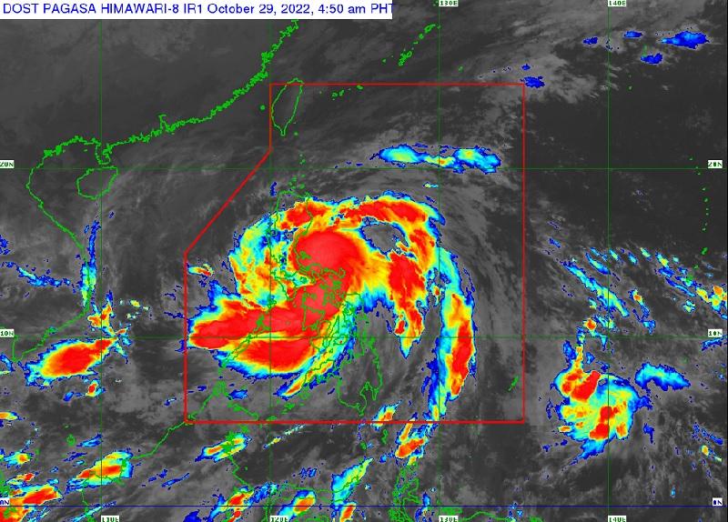
Paeng made landfall over Virac, Catanduanes at 1:10 a.m. and over Caramoan, Camarines Sur at 1:40 a.m.
The center of Paeng was estimated based on all available data including those from Daet and Baler Doppler weather radars to be in the vicinity of Siruma, Camarines Sur at 4 a.m., packing maximum sustained winds of 95 kilometers per hour near the center, gustiness of up to 160 km/h, and central pressure of 985 hPa.
Paeng continues to move west northwestward at the speed of 30 km/h.
From its center, strong to storm-force winds are extending outwards up to 560 km.
Heavy rainfall
On Saturday morning, heavy to intense with at times torrential rains are to be expected in the Bicol Region, Aklan, Antique, Capiz, Iloilo, Guimaras, Quezon including Pollilo Islands, Marinduque, Romblon, Mindoro Provinces, and the northern portion of Palawan including Calamian and Cuyo Islands.
Metro Manila, Aurora, Bulacan, Negros Occidental, Northern Samar, the eastern portion of mainland Cagayan Valley, and the rest of Calabarzon and Palawan will likely have moderate to heavy with at times intense rains.
Meanwhile, light to moderate with at times heavy rains may occur in the Cordillera Administrative Region, Zamboanga Peninsula, and the rest of Cagayan Valley, Central Luzon, and Visayas.
From Saturday morning to evening, Metro Manila, Calabarzon, Marinduque, Romblon, Mindoro Provinces, and the northern portion of Palawan including Calamian and Cuyo Islands will likely have heavy to intense with at times torrential rains.
Mainland Cagayan Valley, Cordillera Administrative Region, Western Visayas, Aurora, Nueva Ecija, Pampanga, Bulacan, Bataan, and Camarines Provinces will likely have moderate to heavy with at times intense rains.
Meanwhile, the Ilocos Region and the rest of Visayas, Central Luzon, and Bicol Region will have light to moderate with at times heavy rains.
From Saturday night to Sunday morning, Metro Manila, Zambales, Bataan, Tarlac, Pampanga, Bulacan, Rizal, Laguna, Cavite, and Batangas will likely have heavy to intense with at times torrential rains.
Mainland Cagayan Valley, Cordillera Administrative Region, Western Visayas, Quezon including Pollilo Islands, Marinduque, Mindoro Provinces, and the rest of Central Luzon will likely experience moderate to heavy with at times intense rains.
Meanwhile, the Ilocos Region, Camarines Provinces, Romblon, and the northern portion of Palawan including Calamian and Cuyo Islands will possibly have light to moderate with at times heavy rains.
"Under these conditions, widespread flooding and rain-induced landslides are expected, especially in areas that are highly or very highly susceptible to these hazard as identified in hazard maps and in localities with significant antecedent rainfall," PAGASA reported.
Severe winds
The weather bureau also said that winds of at most storm-force strength may occur within any of the areas under TCWS No. 3 while winds reaching gale-force strength are possible within any of the areas under TCWS No. 2.
For areas under TCWS No.1, residents may experience strong winds (strong breeze to near gale strength) throughout the passage of Paeng.
"The surge of the Northeast Monsoon enhanced by PAENG will also bring strong winds with gusts reaching gale-force strength over Batanes, Babuyan Islands, Ilocos Norte, the northern and eastern portions of mainland Cagayan, and the northern portion of Apayao," PAGASA added.
Coastal inundation, coastal waters
"There is minimal to moderate risk of storm surge of up to 2.0 m in height which may cause inundation or flooding in the low-lying and exposed coastal areas of mainland Bicol Region, Catanduanes, Aurora, Quezon including Polillo Islands, Marinduque, the northern portion of Masbate including Ticao and Burias Islands, and the eastern portion of Batangas," PAGASA said.
A marine gale warning remains in effect over the seaboards of Luzon and Visayas and the eastern seaboard of Mindanao due to the Northeast Monsoon and Paeng.
Track and intensity outlook
Paeng is forecast to continue moving west northwestward through Sunday across Luzon.
"On the forecast track, the center of PAENG will traverse the Bicol Peninsula until this noon before crossing the CALABARZON-Metro Manila-southern Central Luzon area this early afternoon through tomorrow early morning," PAGASA said.
Paeng may weaken into a tropical storm within 24 hours or earlier due to the frictional effects associated with its interaction with the Luzon landmass, the weather bureau said.
However, it may re-intensify and become a severe tropical storm over the West Philippine Sea.
PAGASA advised the public and disaster risk reduction and management offices concerned to take all necessary measures to protect life and property.
The next bulletin will be issued by PAGASA at 8 a.m.
Classes, dam, lahar advisory
Some provinces, cities and municipalities announced class cancellations for Saturday, October 29, 2022.
Magat Dam in Isabela will release water on October 29 starting at 8 a.m., the National Irrigation Administration said on Friday.
Due to the expected heavy to intense and at times torrential rain from Paeng, the Philippine Institute of Volcanology and Seismology (PHIVOLCS) issued a lahar advisory for Mayon Volcano.
PHIVOLCS warned that Paeng's rains could generate volcanic sediment flows or lahars, muddy streamflows, or muddy run-offs in rivers and drainage areas of Mayon. —BAP/KG, GMA News
