

Signal No. 3 up over NCR, 8 other areas as Paeng crosses Quezon
Tropical Cyclone Wind Signal (TCWS) No. 3 has been raised at 8 a.m. Saturday over the National Capital Region and eight other areas as Severe Tropical Storm Paeng (international name: Nalgae) crossed the Bondoc Peninsula in southern Quezon, PAGASA said in its advisory.
The areas under TCWS No. 3 are:
- National Capital Region;
- Camarines Norte;
- the western portion of Camarines Sur (Del Gallego, Ragay, Lupi, Sipocot, Cabusao, Pasacao, Libmanan, Pamplona);
- Marinduque;
- Quezon including Pollilo Islands;
- Laguna;
- Batangas;
- Cavite; and
- Rizal.
These areas may experience winds greater than 89 km/h up to 117 km/h in at least 18 hours.
PAGASA advised that there may be widespread disruption of electrical power and communication services in areas under TCWS No. 3. High-risk structures may also suffer heavy damage.
TCWS No. 2 meanwhile was raised over:
- Catanduanes;
- Albay;
- the western portion of Sorsogon (Pilar, Castilla, Donsol);
- the western portion of Masbate (Aroroy, Baleno, Mandaon) including Burias Island;
- the southern portion of Aurora (San Luis, Baler, Dingalan, Maria Aurora);
- Bulacan;
- Pampanga;
- Bataan;
- Tarlac;
- Zambales;
- Nueva Ecija;
- Pangasinan;
- the rest of Camarines Sur;
- Romblon;
- Oriental Mindoro; and
- Occidental Mindoro including Lubang Islands.
The above-mentioned areas may have winds greater than 62 km/h and up to 88 km/h in at least 24 hours which may cause light to moderate damage to high risk structures.
TCWS No. 1 on the other hand is in effect over:
- Isabela;
- Nueva Vizcaya;
- Quirino;
- Kalinga;
- Ifugao;
- Mountain Province;
- Benguet;
- Ilocos Sur;
- La Union;
- the rest of Aurora;
- the rest of Sorsogon;
- the rest of Masbate including Ticao Island;
- the northern portion of Palawan (El Nido, Taytay, Dumaran, Araceli, Roxas, San Vicente) including Calamian and Cuyo Islands;
- Northern Samar;
- Samar;
- Eastern Samar;
- Biliran;
- Leyte;
- Southern Leyte;
- Cebu including Bantayan and Camotes Islands;
- Bohol;
- Negros Occidental;
- Negros Oriental;
- Guimaras;
- Aklan;
- Antique; Capiz; and
- Iloilo.
Areas under TCWS No. 1 may have winds of 39-61 km/h in at least 36 hours or intermittent rains within 36 hours.
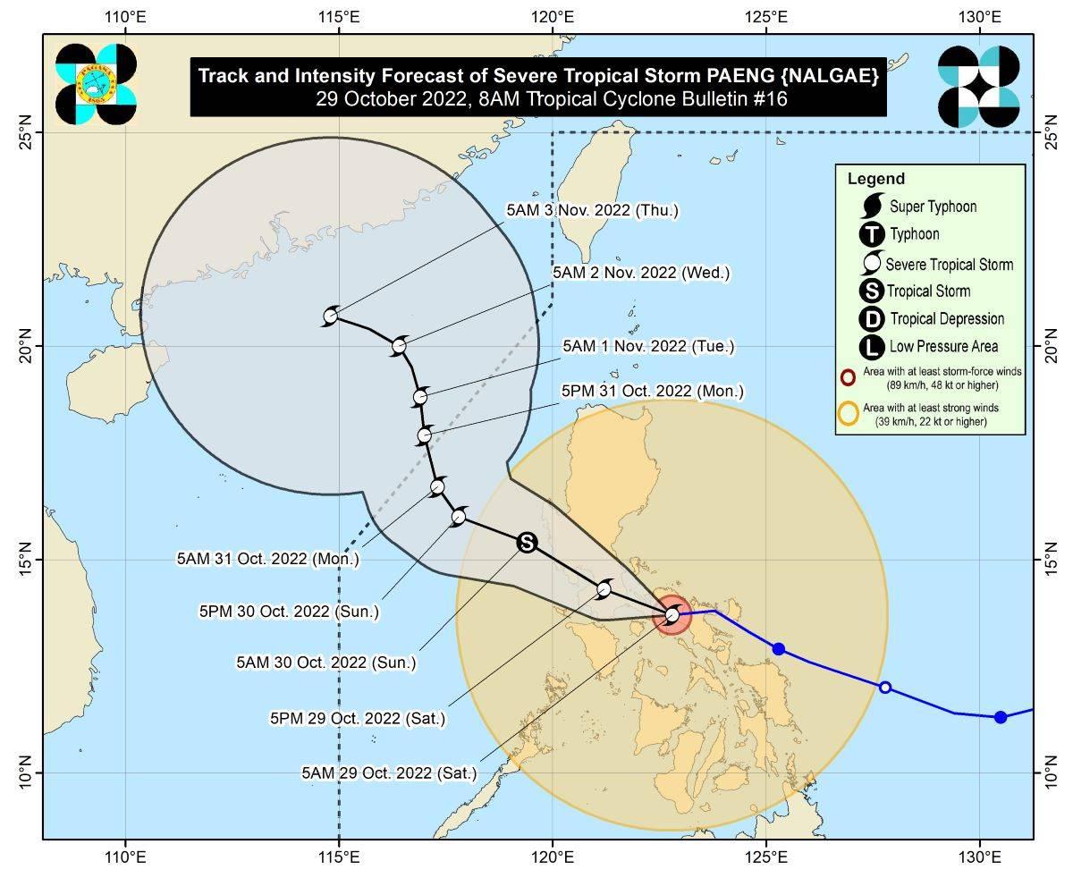
Paeng made landfall over Buenavista, Quezon at 6 a.m. on Saturday after prior landfalls over Virac, Catanduanes at 1:10 a.m. and Caramoan, Camarines Sur at 1:40 a.m.
It was estimated to be located over the coastal waters of Catanauan, Quezon (13.6 °N, 122.3 °E) and monitored to be moving west northwestward at 30 km/h.
Paeng has maximum sustained winds of 95 km/h near the center and gustiness of up to 160 km/h.
Heavy rainfall
PAGASA said the following areas will experience rainfall on Saturday morning:
- Bicol Region, Aklan, Antique, Capiz, Iloilo, Guimaras, Quezon including Pollilo Islands, Marinduque, Romblon, Mindoro Provinces, and the northern portion of Palawan including Calamian and Cuyo Islands: heavy to intense with at times torrential rains;
- Metro Manila, Aurora, Bulacan, Negros Occidental, Northern Samar, the eastern portion of mainland Cagayan Valley, and the rest of Calabarzon and Palawan: moderate to heavy with at times intense rains; and
- Cordillera Administrative Region, Zamboanga Peninsula, and the rest of Cagayan Valley, Central Luzon, and Visayas: light to moderate with at times heavy rains.
From Saturday morning to evening, these areas may expect rains as well:
- Metro Manila, Calabarzon, Marinduque, Romblon, Mindoro Provinces, and the northern portion of Palawan including Calamian and Cuyo Islands: heavy to intense with at times torrential rains;
- mainland Cagayan Valley, Cordillera Administrative Region, Western Visayas, Aurora, Nueva Ecija, Pampanga, Bulacan, Bataan, and Camarines Provinces: moderate to heavy with at times intense rains; and
- Ilocos Region and the rest of Visayas, Central Luzon, and Bicol Region: light to moderate with at times heavy rains.
From Saturday night to Sunday morning, rains may be expected in these areas:
- Metro Manila, Zambales, Bataan, Tarlac, Pampanga, Bulacan, Rizal, Laguna, Cavite, and Batangas: heavy to intense with at times torrential rains;
- mainland Cagayan Valley, Cordillera Administrative Region, Western Visayas, Quezon including Pollilo Islands, Marinduque, Mindoro Provinces, and the rest of Central Luzon: moderate to heavy with at times intense rains; and
- Ilocos Region, Camarines Provinces, Romblon, and the northern portion of Palawan including Calamian and Cuyo Islands: light to moderate with at times heavy rains.
"Under these conditions, widespread flooding and rain-induced landslides are expected, especially in areas that are highly or very highly susceptible to these hazard as identified in hazard maps and in localities with significant antecedent rainfall," PAGASA said.
Severe winds
Areas under TCWS No. 3 may have storm-force strength winds, while those under TCWS No. 2 may experience winds reaching gale-force strength.
Meanwhile, areas under TCWS No. 1 may have strong winds (strong breeze to near gale strength) throughout the passage of Paeng.
"The surge of the Northeast Monsoon enhanced by PAENG will also bring strong winds with gusts reaching gale-force strength over Batanes, Babuyan Islands, Ilocos Norte, the northern and eastern portions of mainland Cagayan, and the northern portion of Apayao," PAGASA said.
Coastal inundation, coastal waters
PAGASA said there is a minimal to moderate risk of storm surge reaching up to 2 meters in height "which may cause inundation or flooding in the low-lying and exposed coastal areas of western Pangasinan, Zambales, Bataan, southern Aurora, Quezon including Polillo Islands, Bulacan, Metro Manila, Cavite, Batangas, Marinduque, Camarines Norte, Camarines Sur, and Albay."
A marine gale warning remains hoisted over the seaboards of Luzon and Visayas and the eastern seaboard of Mindanao due to the influence of the surge of the northeast monsoon and Paeng.
Track, intensity outlook
Paeng is expected to move westward in the short term then move west northwestward across Luzon on Sunday.
The severe tropical storm's center is seen to pass close or make landfall in the vicinity of Marinduque on Saturday morning.
It will then traverse the Calabarzon-Metro Manila-Bataan Peninsula area for the remainder Saturday through early morning of Sunday.
"However, southward shift in the forecast track of PAENG is possible in the succeeding bulletins," PAGASA said.
It added that Paeng may weaken into a tropical storm within 24 hours or possibly even earlier due to frictional effects associated with its interaction with the Luzon landmass.
Once Paeng reaches the West Philippine Sea, however, it may re-intensify into a severe tropical storm.
Paeng is expected to be at 365 km west of Sinait, Ilocos Sur outside the Philippine Area of Responsibility on October 31, 2022 at 5 p.m.
PAGASA advised the public and disaster risk reduction and management offices concerned to take all necessary measures to protect life and property.
The weather bureau will issue the next advisory at 11 a.m.
Classes, flights, dam, lahar advisory
Some provinces, cities and municipalities announced class cancellations for Saturday, October 29, 2022.
At least 94 domestic and international flights for Saturday, October 29, were also canceled due to the bad weather.
Magat Dam in Isabela will release water on October 29 starting at 8 a.m., the National Irrigation Administration said on Friday.
Due to the expected heavy to intense and at times torrential rain from Paeng, the Philippine Institute of Volcanology and Seismology (PHIVOLCS) issued a lahar advisory for Mayon Volcano.
PHIVOLCS warned that Paeng's rains could generate volcanic sediment flows or lahars, muddy streamflows, or muddy run-offs in rivers and drainage areas of Mayon. —KG, GMA News
