

11 areas under Signal No. 1 as Amang threatens Camarines, Quezon
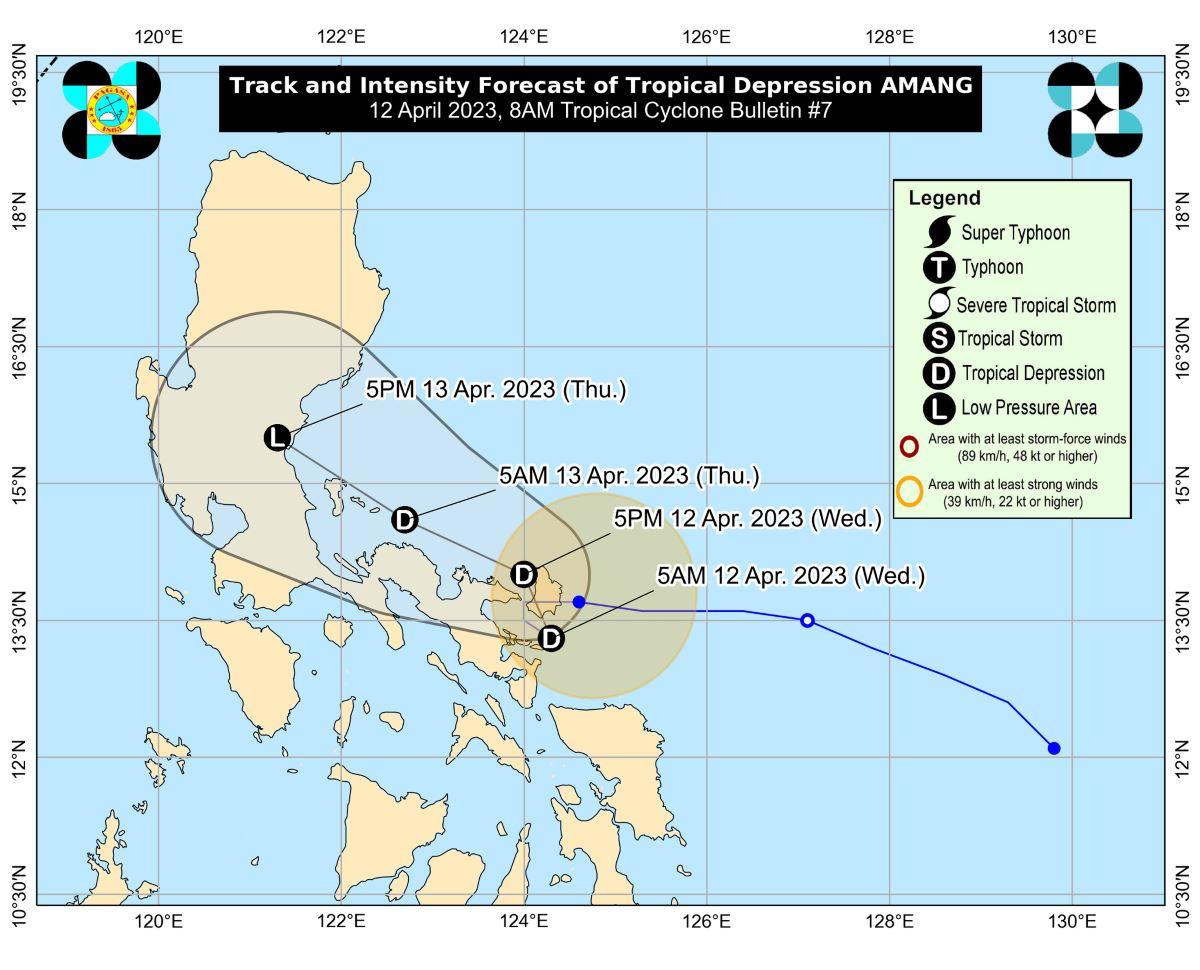
State weather bureau PAGASA on Wednesday said 11 areas are under Tropical Cyclone Wind Signal (TCWS) No. 1 due to Tropical Depression Amang.
In its 8 a.m. bulletin, PAGASA said TCWS No. 1 was hoisted over the following areas:
- Catanduanes;
- Sorsogon;
- Albay;
- Camarines Sur;
- Camarines Norte;
- Ticao Island;
- Burias Island;
- the eastern portion of Laguna (San Pablo City, Rizal, Nagcarlan, Pila, Liliw, Magdalena, Majayjay, Luisiana, Cavinti, Pagsanjan, Santa Cruz, Lumban, Kalayaan, Paete, Pakil, Pangil, Siniloan, Famy, Santa Maria, Mabitac);
- Aurora;
- Quezon; and
- the eastern portion of Rizal (Tanay, Pililla, Jala-Jala).
Amang was estimated to be located over the coastal waters of Virac, Catanduanes with maximum sustained winds of 45 kilometer per hour near the center and gustiness of up to 55 km/h as of 7 a.m. Wednesday.
While it was almost stationary, Amang will move west northwestward in the next 36 hours heading to Camarines Provinces, Lamon Bay, and mainland Quezon with the possibility of passing near or over Polillo Islands, PAGASA said.
PAGASA, however, said the track might change due to the weak and disorganized nature of Amang.
“The tropical depression is forecast to weaken into a low pressure area by tomorrow, possibly earlier, due to the combined effects of land interaction, dry air intrusion, and increasing vertical wind shear,” it said.
For the next 24 hours, PAGASA said an accumulated rainfall of around 50 to 100 millimeters is expected over Camarines Norte, Camarines Sur, and Quezon.
For the next three days, 50-100 mm accumulated rainfall is expected in Calabarzon, Metro Manila, Tarlac, Pampanga, Bulacan, Camarines Norte, Camarines Sur, and the southern portion of Aurora.
“Under these conditions, isolated flashfloods and rain-induced landslides are possible, especially in areas that are highly or very highly susceptible to these hazard as identified in hazard maps and in localities that experienced considerable amounts of rainfall for the past several days," PAGASA said.
Strong winds from strong breeze to near gale strength associated with Amang are expected in areas under TCWS No. 1 that may result in minimal to minor impacts to life and property.
In the next 24 hours, moderate to rough seas up to 3.5 meters may be experienced over the eastern and southern seaboards of Southern Luzon and the eastern seaboard of Central Luzon.
“Mariners of small seacrafts are advised to take precautionary measures when venturing out to sea and, if possible, avoid navigating in these conditions,” PAGASA said.
Classes, stranded passengers, flights
Meanwhile, several classes across Luzon scheduled for Wednesday have been suspended due to Amang.
A total of 1,560 passengers on the other hand got stranded in various ports in the Bicol Region due to the effects of Amang, according to the Office of Civil Defense Region 5 on Wednesday.
Some flights were canceled due to the bad weather, according to the Manila International Airport Authority. —Joviland Rita/KG/RSJ, GMA Integrated News
