

Signal No. 2 up in 3 areas as Betty accelerates over Cagayan waters
Three areas were placed under Tropical Cyclone Wind Signal (TCWS) No. 2 as Typhoon Betty slightly accelerated early Monday morning over the waters east of Cagayan, state weather bureau PAGASA said.
In its 5 a.m. bulletin, PAGASA said the following areas are under TCWS No. 2:
- Batanes,
- the eastern portion of Babuyan Islands (Babuyan Is., Camiguin Is., Didicas Is., Pamuktan Is.), and
- the northeastern portion of mainland Cagayan (Santa Ana)
These areas, PAGASA said, are expected to experience gale-force winds in the next 24 hours that pose "minor to moderate threat to life and property."
Meanwhile, under TCWS No. 1 are:
- The rest of Babuyan Islands,
- the rest of mainland Cagayan,
- Isabela, Quirino,
- the northeastern portion of Nueva Vizcaya (Kasibu, Quezon, Solano, Bagabag, Diadi, Villaverde, Bayombong, Ambaguio),
- Apayao,
- Abra,
- Kalinga,
- Mountain Province,
- Ifugao,
- Ilocos Norte,
- the northern and central portions of Aurora (Dilasag, Casiguran, Dinalungan, Dipaculao, Baler),
- Polillo Islands,
- the northern portion of Catanduanes (Caramoran, Viga, Gigmoto, Panganiban, Bagamanoc, Pandan),
- the northeastern portion of Camarines Sur (Caramoan, Garchitorena, Lagonoy, Tinambac, Siruma), and
- the northern portion of Camarines Norte (Vinzons, Paracale, Jose Panganiban, Capalonga, Talisay, Daet, Mercedes, Basud)
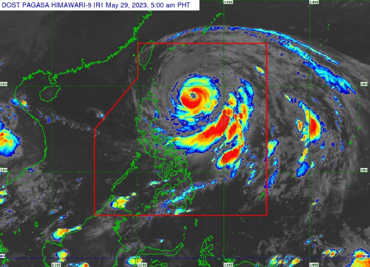
As of 4 a.m., the center of Betty's eye was estimated at 525 km east of Aparri, Cagayan packing maximum sustained winds of 155 km/h, gustiness of up to 190 km/h, and central pressure of 950 hPa.
PAGASA said Betty will move generally northwestward slowly on Monday and may become slow-moving or almost stationary from Tuesday to mid-Wednesday while over the waters east of Batanes.
"Afterwards, the typhoon will turn north northeastward or northeastward on late Wednesday or Thursday and gradually accelerate towards the waters east of Taiwan and the southern portion of Ryukyu Islands," it added.
Betty may be downgraded into a severe tropical storm on late Thursday or early Friday and into a tropical storm on late Friday or early Saturday, PAGASA also said.
Betty, a former super typhoon with an international name of Mawar, is expected to exit the Philippine Area of Responsibility (PAR) on Friday.
As a precaution, classes in some areas were canceled on Monday, as were some flights.
The Philippine Coast Guard (PCG), however, said it has not issued no-sail policy in light of Typhoon Betty, although some private companies have suspended trips to Cebu, Leyte, Surigao and parts of Eastern Visayas, according to a tweet by GMA Integrated News' Chino Gaston. No stranded passengers have been reported so far.
PCG has not issued no sail policy in light of typhoon Betty. However some private companies have suspended trips to Cebu, Leyte, Surigao and parts of Eastern Visayas. No stranded passengers reported so far. pic.twitter.com/QvJ9J4LORO
— Chino Gaston (@chinogaston) May 29, 2023
The National Disaster Risk Reduction and Management Council (NDRRMC), meanwhile, has activated its emergency preparedness and response (EPR) protocols in preparation for Betty's onslaught.
As Betty continued to pose threat to areas under TCSW, thousands of individuals have started congregating in evacuation centers, according to the Department of Social Welfare and Development (DSWD), which has started distributing food packs to the affected families.
In an interview on Unang Balita, DSWD Assistant Secretary Romel Lopez said in the Ilocos Region, particularly in La Union and Ilocos Sur, 21,000 family food packs were handed out while in Batanes, 850 food packs were distributed.
A number of tourists were also stranded in Batanes due to strong waves and winds in the province brought by Betty, according to Batanes Emergency Operation Center’s Justinne Jerico Socito.
Socito said all tourists are well accounted for and the provincial government is ensuring that they will receive necessary assistance.
According to him, Batanes is now experiencing strong winds and waves as well as cloudy skies. —KBK, GMA Integrated News
