

Dodong makes landfall in Dinapigue, Isabela; Signal No. 1 remains over 15 areas
Fifteen areas remained under Tropical Cyclone Wind Signal (TCWS) No. 1 as Tropical Depression Dodong mades landfall in Dinapigue, Isabela early Friday morning, according to PAGASA.
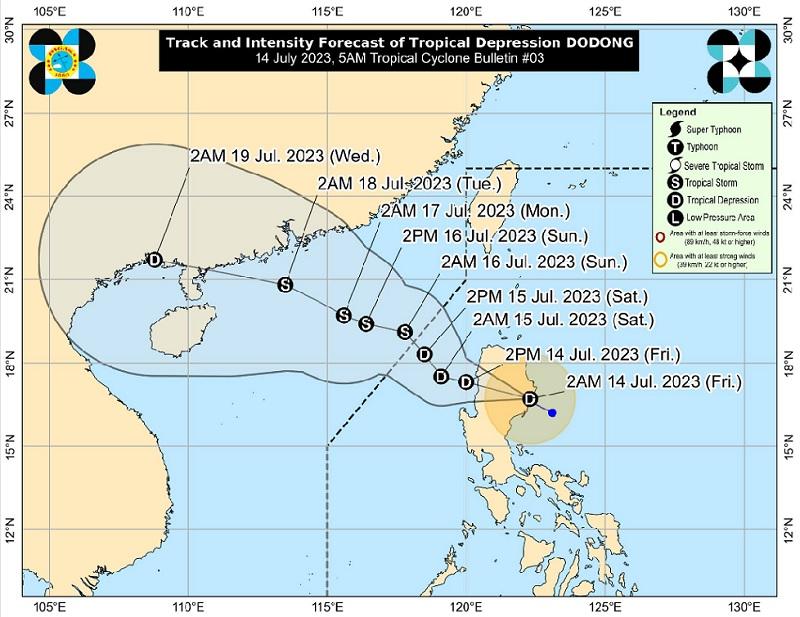
In its 5 a.m. bulletin, PAGASA said that as of 4 a.m., the center of Dodong was estimated to be in the vicinity of San Mariano, Isabela packing maximum sustained winds of 45 kilometers pear hour near the center, gustiness of up to 55 km/h, and central pressure of 1000 hPa.
Dodong was moving west northwestward at a speed of 15 km/h with strong winds extend outwards up to 180 km from the center, PAGASA said.
TCWS No. 1 has been hoisted over the following areas:
- Cagayan
- Isabela
- Quirino
- Nueva Vizcaya
- Apayao
- Kalinga
- Abra
- Mountain Province
- Ifugao
- Benguet
- Ilocos Norte
- Ilocos Sur
- La Union
- the northern portion of Pangasinan (San Nicolas, San Manuel, Sison, San Fabian, Pozorrubio, Bolinao, Bani, City of Alaminos, Sual, Labrador, Lingayen, Agno, Binmaley, Dagupan City, San Jacinto, Mangaldan, Anda)
- the northern and central portions of Aurora (Maria Aurora, San Luis, Baler, Dipaculao, Dinalungan, Casiguran, Dilasag)
According to PAGASA, Dodong's wind speed ranges from 39 to 61 km/h (Beaufort 6 to 7) with minimal to minor threat of the impacts to life and property.
Hazards affecting land areas
PAGASA said 50-100 mm accumulated rainfall is expected on Friday in Cagayan, Isabela, Quirino, Nueva Vizcaya, Apayao, Kalinga, Benguet, Ilocos Norte, La Union, Pangasinan, and the northern portion of Aurora.
"Under these conditions, flooding and rain-induced landslides are possible, especially in areas that are highly or very highly susceptible to these hazard as identified in hazard maps and in localities that experienced considerable amounts of rainfall for the past several days," the state weather bureau said.
Cagayan Valley, Cordillera Administrative Region, Ilocos Region, and the northern portion of Aurora will have rains with gusty winds due to Dodong, PAGASA said.
Flooding or landslides may occur in these areas due to moderate to heavy rains. There will be, however, minimal to minor threat to lives and properties due to strong winds.
Metro Manila, CALABARZON, and MIMAROPA, and the rest of Central Luzon will have monsoon rains due to Dodong and the southwest monsoon or Habagat, with the possibility of flooding or landslides occurring due to scattered to widespread rains.
The Bicol Region and Western Visayas will have occasional rains due to the Habagat and flooding or landslides may occur due to scattered to widespread rains, PAGASA said.
In the Zamboanga Peninsula and the rest of Visayas, there will be cloudy skies with scattered rain showers and thunderstorms due to the Habagat. Flash floods or landslides may occur due to moderate to at times heavy rains.
The rest of Mindanao will have partly cloudy to cloudy skies with isolated rain showers or thunderstorms due to the Habagat and localized thunderstorms. Flash floods or landslides may occur during severe thunderstorms.
Severe winds
There will be minimal to minor impacts from strong winds within any of the areas where Signal No.1 is in effect.
The enhanced Southwest Monsoon may bring gusty conditions over the following areas: MIMAROPA, Bicol Region, Western Visayas, CALABARZON, Metro Manila, and other areas of Central Luzon not under any wind signal.
Hazards affecting coastal waters
"In the next 24 hours, Dodong and the enhanced southwest monsoon may bring moderate to rough seas over the eastern (1.5 to 2.5 m) and western (2.0 to 3.5 m) seaboards of Northern Luzon, and the western seaboards of Central and Southern Luzon (2.0 to 3.5 m)," PAGASA reported.
"Mariners of small seacrafts are advised to take precautionary measures when venturing out to sea. If inexperienced or operating ill-equipped vessels, avoid navigating in these conditions," the agency added.
Track and intensity outlook
Dodong is forecast to cross the rugged landmass of Northern Luzon on Friday.
"Although not captured in the track forecast, the tropical depression may initially track northwestward or north northwestward over Cagayan Valley for the next 6 hours before turning more west northwestward or westward and emerging over the waters west of Ilocos Region," said PAGASA.
Dodong will then continue to move generally northwestward over the West Philippine Sea and leave the Philippine Area of Responsibility (PAR) on Saturday or Sunday.
Dodong may reach tropical storm category by late tomorrow or early Sunday as it moves out of the PAR. — BAP, GMA Integrated News
