

Egay makes landfall over Fuga Island, Aparri, Cagayan; Signal No. 4 up over 3 areas
Typhoon Egay (international name: Doksuri) made landfall over Fuga Island in Aparri, Cagayan before dawn on Wednesday.
PAGASA raised Tropical Cyclone Wind Signal No. 4 over parts of Cagayan, Apayao, and Ilocos Norte due to the threat of Egay.
Areas under TCWS No. 4 are:
- the northern portion of Cagayan (Santa Ana, Gonzaga, Claveria, Sanchez-Mira, Pamplona, Abulug, Ballesteros, Aparri, Buguey, Santa Teresita, Camalaniugan, Santa Praxedes) including Babuyan Islands;
- the northern portion of Apayao (Calanasan, Luna, Santa Marcela); and
- the northern portion of Ilocos Norte (Burgos, Bangui, Dumalneg, Pagudpud, Adams, Pasuquin, Vintar, Bacarra).
These areas will have typhoon-force winds ranging from 118 to 184 km/h in 12 hours, which may pose significant to severe threat to life and property, PAGASA said.
TCWS No. 3 meanwhile has been raised over:
- Batanes;
- the rest of Cagayan;
- the rest of Apayao;
- the northern portion of Kalinga (Rizal, Pinukpuk, Balbalan);
- the northern portion of Abra (Tineg, Lagayan, Lacub, Danglas, Bangued, La Paz, San Juan, Dolores, Tayum, Lagangilang, Malibcong, Licuan-Baay, Peñarrubia, Pidigan, Langiden, San Quintin, Bucay, San Isidro, Sallapadan);
- the rest of Ilocos Norte; and
- the northern portion of Ilocos Sur (Magsingal, San Juan, Cabugao, Sinait, San Vicente, Santo Domingo, San Ildefonso, Bantay, Santa Catalina, City of Vigan, Caoayan, Santa, Nagbukel, Narvacan).
Areas under TCWS No. 3 will have storm-force winds ranging from 89 to 117 km/h in 18 hours that may pose moderate to significant threat to life and property, the weather bureau said.
TCWS No. 2 is in effect over the following areas:
- Isabela;
- the rest of Kalinga;
- Mountain Province;
- Ifugao;
- Benguet;
- the rest of Abra;
- the rest of Ilocos Sur; and
- La Union.
These areas under TCWS No. 2 may expect gale-force winds ranging from 62 to 88 km/h in 24 hours, posing potential minor to moderate threat to life and property.
TCWS No. 1 on the other hand was raised over:
- Aurora;
- Quirino;
- Nueva Vizcaya;
- Pangasinan;
- Nueva Ecija;
- Tarlac;
- Pampanga;
- Bulacan;
- Zambales;
- Bataan;
- Metro Manila;
- Rizal;
- Cavite;
- Laguna;
- the northern portion of Batangas (Talisay, City of Tanauan, Santo Tomas, Balete, Malvar, Lipa City);
- the northern and central portion of Quezon (Pitogo, Calauag, Infanta, Lopez, Guinayangan, Unisan, Plaridel, Quezon, Alabat, Padre Burgos, Mauban, General Nakar, Perez, Agdangan, Gumaca, Atimonan, Real, Tagkawayan, Lucena City, Pagbilao, Lucban, Sampaloc, City of Tayabas, Dolores, Sariaya, Candelaria, Tiaong, San Antonio) including Polillo Islands;
- Camarines Norte;
- the northern portion of Camarines Sur (Siruma, Tinambac, Goa, Lagonoy, Caramoan, Cabusao, Sipocot, Garchitorena, Ragay, Del Gallego, Calabanga, Presentacion, Lupi); and
- the northern portion of Catanduanes (Pandan, Bagamanoc, Panganiban, Viga, Caramoran).
The above mentioned areas under TCWS No. 1 will experience strong winds ranging from 39 to 61 km/h in 36 hours, with minimal to minor threat to life and property.
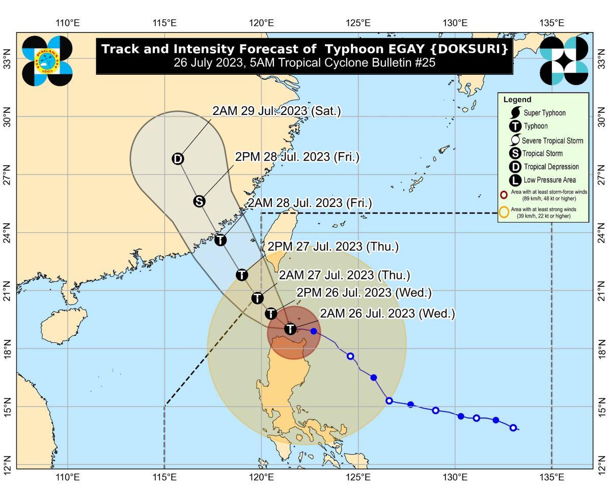
Egay made landfall in the vicinity of Fuga Island at 3:10 a.m., PAGASA said.
Location
At 4 a.m., the eye of Egay was estimated to be located over the coastal waters of Aparri, Cagayan.
It has maximum sustained winds of 175 km/h near the center, gustiness of up to 240 km/h, and central pressure of 935 hPa.
Egay is moving westward at 20 km/h.
From its center, strong to typhoon-force winds are extending outwards up to 700 km.
Rainfall
The northwestern portion of Cagayan including Babuyan Islands, the northern portion of Apayao, Abra, Ilocos Norte, and Ilocos Sur may have more than 200 mm of rainfall on Wednesday, PAGASA said.
Batanes, the northeastern and central portions of Cagayan, the rest of Apayao, the western portion of Kalinga, the western portion of Mountain Province, Benguet, and La Union may expect 100 to 200 mm of rainfall on Wednesday.
Meanwhile, 50 to 100 mm of rainfall may be expected in the rest of Cagayan, the rest of Kalinga, the rest of Mountain Province, the western portion of Ifugao, the western portion of Nueva Vizcaya, Pangasinan, and Zambales.
The amount of rainfall may be higher in elevated or mountainous areas.
"Under these conditions, flooding and rain-induced landslides are highly likely especially in areas that are highly or very highly susceptible to these hazards as identified in hazard maps and in localities that experienced considerable amounts of rainfall for the past several days," PAGASA said.
Meanwhile, Egay is enhancing the Southwest Monsoon (Habagat) which will continue to bring occasional to monsoon rains over the western portions of Central Luzon, Southern Luzon, and Visayas in the next three days.
Winds
"Violent, life-threatening conditions are expected to continue over Babuyan Islands, the northwestern portion of mainland Cagayan, and the northern portions of Apayao and Ilocos Norte in the next 6 hours," PAGASA said.
Gusty conditions due to Egay and the enhanced Southwest Monsoon will also be felt in the following areas not under TCWS, especially in coastal and upland/mountainous areas exposed to winds:
- Wednesday: Luzon and Visayas;
- Thursday: Luzon and Western Visayas; and
- Friday: Batanes, Ilocos Region, Zambales, Bataan, Cavite, the southern portion of Quezon, MIMAROPA, Bicol Region, and Western Visayas.
Coastal inundation
PAGASA warned of a high risk of storm surge which may cause flooding in the following areas:
- the low-lying and exposed coastal areas of Batanes, Cagayan including Babuyan Islands, Ilocos Norte; and
- portions of Isabela and Ilocos Sur.
The storm surge may exceed 3 meters in most of the warning areas, PAGASA said.
Coastal waters
A gale warning was raised over several coastal waters along the seaboards of Luzon and Visayas due to Egay and the monsoon.
Rough to high or very high seas may be expected in some areas, making sea travel risky for most vessels.
Track, intensity outlook
Egay may have "trochoidal or wobbling motion while in the vicinity of the Babuyan Islands" in the next six hours, PAGASA said in its 5 a.m. bulletin.
"As such, a landfall over northwestern Cagayan is not ruled out," it added.
Egay is expected to turn generally northwestward or north northwestward and pass over the waters south and southwest of Taiwan.
The typhoon is expected to exit the Philippine Area of Responsibility on Thursday morning.
On Friday morning, Egay is expected to make landfall in the vicinity of Fujian, China.
PAGASA said the typhoon may weaken though not rapidly.
The weather bureau advised the public and disaster risk reduction and management offices concerned to take all necessary precautions to protect life and property.
PAGASA will issue the next weather bulletin at 8 a.m.
Sunrise was at 5:38 a.m. while sunset will be at 6:27 p.m. —KG, GMA Integrated News
