

Egay exits PAR; Signal No. 2 still up in 8 areas —PAGASA
Typhoon Egay has left the Philippine Area of Responsibility (PAR) but rains will continue to persist in parts of the country, according to state weather bureau PAGASA on Thursday.
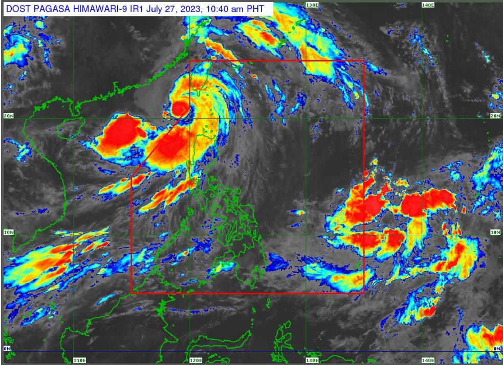
In an interview on Super Radyo dzBB, weather forecaster Anna Clauren said Egay left PAR at 8 a.m.
“Kaninang alas-8 ng umaga lumabas na eto (Egay) ng Philippine area of resposbnibility, pero hindi pa tayo nag-lilift ng warning signals dahil malawak ang kanyang sirkulasyon,” Clauren said.
"May epekto pa din po and Egay sa locos region, Cordillera, Cagayan, pati Babuyan Island," she added.
TCWS No. 2
Batanes
Cagayan
Babuyan Islands
Apayao
Kalinga
Abra
Ilocos Norte
The northern and central portion of Ilocos Sur (Magsingal, San Esteban, Banayoyo, Burgos, City of Candon, Santiago, San Vicente, Santa Catalina, Lidlidda, Nagbukel, Sinait, San Ildefonso, Galimuyod, City of Vigan, San Emilio, Cabugao, Caoayan, San Juan, Santa, Bantay, Santo Domingo, Santa Maria, Narvacan)
TCWS No.1
Isabela
Quirino
Nueva Vizcaya
Mountain Province
Ifugao
Benguet
the rest of Ilocos Sur
La Union
Pangasinan
Aurora
Nueva Ecija
Tarlac
the northern portion of Zambales (Botolan, Iba, Candelaria, Cabangan, Palauig, Santa Cruz, Masinloc)
Habagat
Rainy weather is also expected to continue in other parts of the country due to the enhanced Southwest Monsoon or Habagat.
"Dito sa Central Luzon... pati na din Metro Manila Habagat naman po nakakaapekto.... So, may pabugso-bugso pa din (na ulan) po tayong inaasahan," Clauren explained.
Hazards on coastal waters
In its 11 a.m. bulletin, PAGASA added that a Gale Warning is in effect over several coastal waters along the seaboards of Luzon and the eastern and western seaboards of Visayas due to Egay and the enhanced Southwest Monsoon.
Sea travel will be risky for most vessels due to rough to high or very high seas, and all mariners are advised to remain in port or seek safe harbor until winds and waves subside.
Sea travel will also be risky for small seacrafts under rough to very rough seas.
Track and Intensity Outlook
PAGASA said Egay is forecast to track north northwestward over the Luzon Strait, the sea southwest of Taiwan, and the Taiwan Strait throughout the forecast period while gradually accelerating.
The center of the eye of Typhoon Egay was estimated based on all available data at 255 km west of Itbayat, Batanes (OUTSIDE PAR) (20.9 °N, 119.4 °E).
Moving North Northwestward at 15 km/h, Egay has maximum sustained winds of 150 km/h near the center and gustiness of up to 185 km/h.
Class suspensions
Classes and government work for Thursday, July 27, 2023, have been suspended in some areas due to Typhoon Egay.
Benguet
Mamburao
Sta. Cruz, Occidental Mindoro
Classes in all levels in public and private schools are also suspended in Angeles, Pampanga.
Canceled flights
Airport authorities also announced the cancellation of some flights:
PAL Express
Manila-Basco-Manila
2P 2932/2933
Manila-Laoag-Manila
2P 2196/2197
2P 2198/2199
Cebu Pacific
Manila-Laoag-Manila
5J 404/405
Cebgo
Manila-Masbate-Manila
DG 6177/6178
Impact
The National Disaster Risk Reduction and Management Council (NDRRMC) is validating five reported deaths amid the onslaught of Typhoon Egay. Four of the deaths are from Benguet who reportedly died due to a landslide.
The total affected population is at 89,639 while total affected persons are 328,356 in 11 regions.
A total of 6,793 persons were pre-emptively evacuated from Region 1, Region 2, Region 3, MIMAROPA, Region 6 while there are 26,697 persons displaced. —Jamil Santos/ VAL, GMA Integrated News
