

Signal No. 2 over 6 areas as Kabayan intensifies into tropical storm
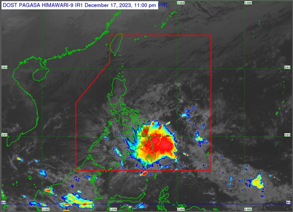
Tropical Depression Kabayan has intensified into a tropical storm, PAGASA said in its 11 p.m. bulletin on Sunday night.
According to the state weather bureau, the center of the storm was estimated to be 275 km east of Davao City as of 4 p.m. It is moving west-northwest at 15 km/h with maximum sustained winds of 65 km/h near the center, gustiness of up to 80 km/h, and central pressure of 1000 hPa.
"Strong to gale-force winds extend outwards up to 420 km from the center," PAGASA added.
Storm Signal No. 2 has been hoisted over the following areas:
- Dinagat Islands,
- Surigao del Norte including Siargao and Bucas Grande Islands,
- Surigao del Sur,
- the northern portion of Agusan del Norte (Kitcharao, Jabonga, Santiago, City of Cabadbaran, Remedios T. Romualdez, Tubay),
- the eastern portion of Agusan del Sur (Trento, Bunawan, San Francisco, Rosario, Prosperidad, City of Bayugan, Sibagat),
- and the northern portion of Davao Oriental (Boston, Cateel)
Signal No. 1, meanwhile, is raised over:
Visayas
- Southern Leyte,
- Leyte,
- the southern portion of Samar (Basey, Santa Rita, Marabut, Talalora, Villareal, Pinabacdao),
- the southern portion of Eastern Samar (Maydolong, City of Borongan, Quinapondan, Guiuan, Lawaan, Balangiga, Llorente, Giporlos, Salcedo, Balangkayan, General Macarthur, Hernani, Mercedes),
- Cebu including Camotes and Bantayan Islands,
- Bohol,
- Siquijor,
- Negros Oriental, and
- Negros Occidental
Mindanao
- The rest of Agusan del Norte,
- the rest of Agusan del Sur,
- the central portion of Davao Oriental (Baganga, Manay, Caraga),
- Davao de Oro,
- Davao del Norte,
- Davao City,
- Camiguin,
- Misamis Oriental,
- Misamis Occidental,
- Lanao del Norte,
- Lanao del Sur,
- the northern portion of Maguindanao del Norte (Buldon, Barira, Matanog),
- the northern portion of Cotabato (Arakan, Carmen, Banisilan, Alamada, President Roxas, Kabacan, Matalam, Antipas, Magpet),
- the northern portion of Zamboanga del Sur (Midsalip, Labangan, Tukuran, Aurora, Sominot, Ramon Magsaysay, Tambulig, Dumingag, Mahayag, Josefina, Molave), and
- the northeastern portion of Zamboanga (Siayan, Sindangan, Jose Dalman, Manukan, Pres. Manuel A. Roxas, Sergio Osmeña Sr., Katipunan, Dipolog City, Polanco, Mutia, Piñan, Dapitan City, Sibutad, La Libertad, Rizal)
Track, landfall
PAGASA expects Kabayan to keep moving west or west-northwest across the Philippines over the next two days, remaining a tropical storm until its likely initial landfall in Mindanao.
The storm is forecast to make landfall along Surigao del Sur or Davao Oriental coast in the next few hours.
PAGASA also forecasts the following amount of rainfall in some areas tonight until tomorrow evening:
- Above 200 mm: The northern portion of Surigao del Sur
- 100-200 mm: The rest of Surigao del Sur, Surigao del Norte, Dinagat Islands, Camiguin, and Southern Leyte
- 50-100 mm: Leyte, Biliran, Bohol, the northern portions of Davao de Oro, Davao del Norte, and Davao Oriental, the southern portions of Eastern Samar and Samar, and the rest of Caraga and Northern Mindanao.
— BM, GMA Integrated News
