

Kabayan moves closer to Davao Oriental; Signal No. 2 over 6 areas
Tropical Storm Kabayan moves closer to Davao Oriental and may make landfall in the coastal area of the province or Surigao del Sur soon, PAGASA said early morning on Monday as Signal No. 2 remains hoisted over six areas in Mindanao.
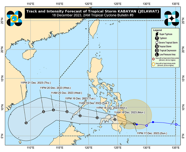
In its tropical cyclone bulletin issued at 2 a.m. on Monday, the state weather bureau said that Kabayan (international name: Jelawat) continues to move west-northwest at 15 km/h with maximum sustained winds of 65 km/h near the center and gustiness of up to 80 km/h. The center of the storm's eye is estimated to be 225 km east of Davao City.
PAGASA also expects Kabayan to make landfall "along the coast of southern Surigao del Sur or Davao Oriental this morning."
Signal No. 2 is hoisted over the following areas:
- Dinagat Islands,
- Surigao del Norte including Siargao and Bucas Grande Islands,
- Surigao del Sur,
- the northern portion of Agusan del Norte (Kitcharao, Jabonga, Santiago, City of Cabadbaran, Remedios T. Romualdez, Tubay),
- the eastern portion of Agusan del Sur (Trento, Bunawan, San Francisco, Rosario, Prosperidad, City of Bayugan, Sibagat), and
- the northern portion of Davao Oriental (Boston, Cateel)
Signal No. 1 is hoisted over the following areas across the country:
Luzon
- Cagayancillo Islands
Visayas
- Southern Leyte,
- Leyte,
- the southern portion of Samar (Basey, Santa Rita, Marabut, Talalora, Villareal, Pinabacdao),
- the southern portion of Eastern Samar (Maydolong, City of Borongan, Quinapondan, Guiuan, Lawaan, Balangiga, Llorente, Giporlos, Salcedo, Balangkayan, General Macarthur, Hernani, Mercedes),
- Cebu including Camotes and Bantayan Islands,
- Bohol,
- Siquijor,
- Negros Oriental,
- Negros Occidental, and
- Guimaras
Mindanao
- The rest of Agusan del Norte,
- the rest of Agusan del Sur,
- the central portion of Davao Oriental (Baganga, Manay, Caraga, Tarragona, Lupon, Banaybanay),
- Davao de Oro,
- Davao del Norte,
- Davao City,
- Camiguin,
- Misamis Oriental,
- Misamis Occidental,
- Lanao del Norte,
- Lanao del Sur,
- the northern portion of Maguindanao del Norte (Buldon, Barira, Matanog),
- the northern portion of Cotabato (Arakan, Carmen, Banisilan, Alamada, President Roxas, Kabacan, Matalam, Antipas, Magpet),
- Zamboanga del Sur, and
- the northeastern portion of Zamboanga del Norte (Siayan, Sindangan, Jose Dalman, Manukan, Pres. Manuel A. Roxas, Sergio Osmeña Sr., Katipunan, Dipolog City, Polanco, Mutia, Piñan, Dapitan City, Sibutad, La Libertad, Rizal)
PAGASA also forecasts the following amounts of rain to fall from tonight through Monday evening:
- Above 200 mm: The northern portion of Surigao del Sur
- 100-200 mm: The rest of Surigao del Sur, Surigao del Norte, Dinagat Islands, Camiguin, and Southern Leyte
- 50-100 mm: Central Visayas, Leyte, Biliran, the northern portions of Davao de Oro, Davao del Norte, and Davao Oriental, the southern portions of Eastern Samar and Samar, and the rest of Caraga and Northern Mindanao.
— BM, GMA Integrated News
