

4 areas under Signal No. 1 as LPA develops into TD Aghon
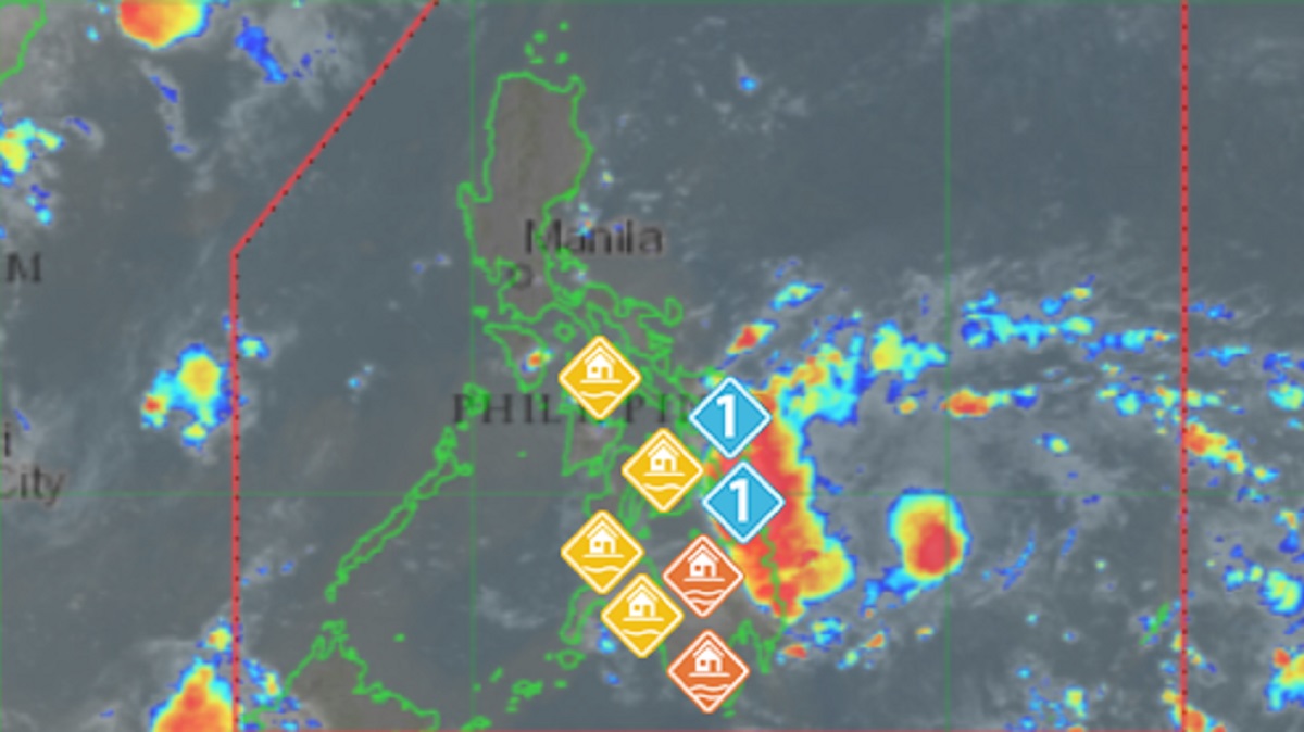
Four areas were placed under Tropical Cyclone Wind Signal (TCWS) No. 1 as the low pressure area east of Surigao del Sur developed in Tropical Depression Aghon, state weather bureau PAGASA said Friday.
In its 5 a.m. tropical cyclone bulletin, PAGASA said the four areas under TCWS No 1 are:
- Eastern Samar
- Dinagat Islands
- Siargao Islands
- Bucas Grande Islands
PAGASA said these areas may experience intermittent rains or winds of 39 to 61 km/h or within the next 36 hours.
As of 5 a.m., the center of Aghon's eye was estimated at 340 km east of Hinatuan in Surigao del Sur. It was moving west northwestward at 30 km/h packing maximum sustained winds of 45 km/h near the center and gustiness of up to 55 km/h.
Aghon, the first tropical cyclone to hit the country this year, is forecast to move generally northwestward or north northwestward from Friday until Saturday while slowly intensifying.
PAGASA said Aghon may "make a close approach or make landfall" in the vicinity of Eastern Samar on Saturday morning as a tropical depression.
"Afterwards, AGHON will pass north northwestward over Eastern Visayas, then emerge over the waters off the east coast of Bicol Region tomorrow afternoon or evening as a tropical storm," it said.
On Sunday, the cyclone will begin "recurving" generally northeastward or north northeastward over the waters east of Luzon while starting to continuously intensify.
"Current forecast scenario shows intensification into a severe tropical storm by mid Sunday and into a typhoon by Tuesday," PAGASA said.
Weather forecast
In its weather bulletin for the day, PAGASA said Eastern Samar and Dinagat Islands will have rains with gusty winds due to Aghon with possible flooding or landslides due to moderate to heavy rains.
Bicol Region, Northern Mindanao, Davao Region, and the rest of Visayas and Caraga, meanwhile, will have cloudy skies with scattered rain showers and thunderstorms also due to Aghon with possible flash floods or landslides due to moderate to at times heavy rains.
Metro Manila and the rest of the country, on the other hand, will have partly cloudy to cloudy skies with isolated rain showers or thunderstorms due to the easterlies with possible flash floods or landslides during severe thunderstorms.
The eastern section of Southern Luzon and Visayas will experience moderate to strong wind speed moving in the east to northeast direction while coastal waters will be moderate to rough.
The eastern section of Northern and Central Luzon will experience moderate wind speed moving in the east to southeast direction while coastal waters will be moderate.
Mindanao will experience light to moderate wind speed moving southwestward with slight to moderate coastal waters.
The wind speed forecast for the rest of the country is light to moderate moving in the east to northeast direction with slight to moderate coastal waters.
Sunrise will be at 5:27 a.m., sunset at 6:19 p.m. — BAP/KBK, GMA Integrated News
