

Aghon now a storm, Signal No. 2 up over parts of Quezon
Tropical Depression Aghon intensified and became a storm while over Tayabas Bay early Sunday, and parts of Quezon Province were placed under Tropical Cyclone Wind Signal No. 2, according to PAGASA.
TCWS No. 2 was hoisted over the northern and central portions of Quezon (Alabat, Perez, Quezon, Gumaca, Lopez, Macalelon, General Luna, Unisan, Pitogo, Plaridel, Agdangan, Padre Burgos, Atimonan, Mauban, Real, General Nakar, Infanta, Sampaloc, Pagbilao, Calauag, Lucban, City of Tayabas, Lucena City) including Polillo Islands.
These areas will have gale-force winds with speeds ranging from 62 to 88 km/h in 24 hours, posing minor to moderate threat to life and property.
TCWS No. 1 on the other hand is in effect over:
- the southeastern portion of Isabela (Palanan, Dinapigue);
- the southern portion of Quirino (Maddela, Nagtipunan);
- the southern portion of Nueva Vizcaya (Alfonso Castaneda);
- the eastern and southern portions of Nueva Ecija (General Tinio, Gabaldon, Bongabon, Pantabangan, Rizal, General Mamerto Natividad, Laur, Palayan City, Peñaranda, San Leonardo, City of Gapan, Cabanatuan City, Santa Rosa, San Isidro, Cabiao, San Antonio, Jaen);
- Aurora;
- the eastern portion of Pampanga (Candaba, San Luis, San Simon, Apalit, Santa Ana, Arayat);
- Bulacan;
- Metro Manila;
- the rest of Quezon;
- Rizal;
- Laguna;
- Cavite;
- Batangas;
- the northern portion of Oriental Mindoro (Pinamalayan, Pola, Naujan, Victoria, Socorro, City of Calapan, Bansud, Gloria, Baco, San Teodoro, Puerto Galera, Bongabong, Roxas);
- Marinduque;
- Romblon;
- Camarines Norte;
- Camarines Sur;
- the northern portion of Albay (Tiwi, Polangui, Malinao, Libon, Oas, City of Ligao); and
- Burias Island.
Areas under TCWS No. 1 may expect strong winds with speeds ranging from 39 to 61 km/h in 36 hours, posing minimal to minor threat to life and property.
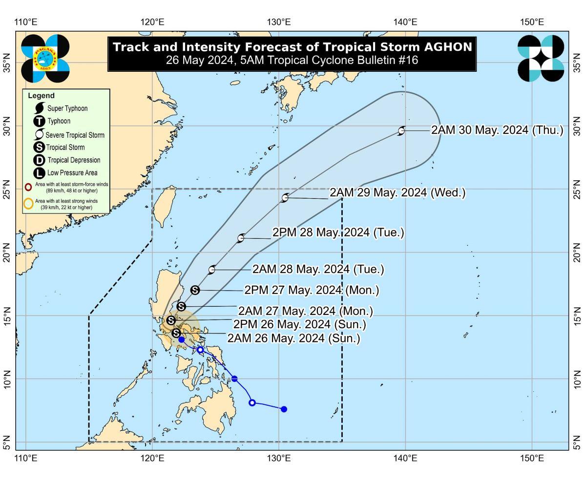
At 4 a.m., the center of Aghon was estimated to be located over the coastal waters of Lucena City in Quezon.
Aghon has maximum sustained winds of 65 km/h near the center, gustiness of up to 90 km/h, and central pressure of 1000 hPa.
The tropical storm is moving northwestward at 10 km/h.
From its center, strong to gale-force winds are extending outwards up to 220 km.
Rainfall
The weather bureau said Quezon will have more than 200 mm of rainfall on Sunday.
Meanwhile, Aurora, the eastern portion of Bulacan, Rizal, Laguna, Metro Manila, and Camarines Norte may expect 100 to 200 mm of rainfall.
Nueva Ecija, the rest of Bulacan, the eastern portion of Pampanga, the rest of CALABARZON, Oriental Mindoro, Occidental Mindoro, Romblon, Burias Island, and the western portion of Camarines Sur on the other hand will have 50 to 100 mm of rainfall today.
On Monday, the eastern portion of Isabela, the northern portion of Aurora, and Polillo Islands may expect 50 to 100 mm of rainfall.
"Forecast rainfall are generally higher in elevated or mountainous areas. Under these conditions, flooding and rain-induced landslides are likely especially in areas that are highly or very highly susceptible to these hazards as identified in hazard maps and in localities that experienced considerable amounts of rainfall for the past several days," PAGASA said.
Coastal waters
The weather bureau issued a gale warning over the coastal waters of Marinduque and Quezon, the southern coastal waters of Batangas, and the northern coastal waters of Camarines Norte due to Aghon.
"Sea travel is risky for small seacrafts, including all motorbancas of any type of tonnage," PAGASA said.
Coastal waters along the northern and eastern seaboards of Luzon and the seaboard of Bicol Region will be moderate to rough.
"Mariners of motor bancas and similarly-sized vessels are advised to take precautionary measures while venturing out to sea and, if possible, avoid navigating in these conditions, especially if inexperienced or operating ill-equipped vessels," the weather bureau said.
Track, intensity outlook
The tropical storm is expected to make landfall in the vicinity of Quezon within the next three hours from 5 a.m.
From there, Aghon will cross the landmass of mainland Calabarzon and Polillo Islands in the next 12 hours.
By Sunday evening or Monday early morning, Aghon is forecast to be over the waters off the east coast of Quezon or Aurora.
PAGASA said Aghon will likely remain as a tropical storm but there is a possibility it may weaken into a tropical depression while over mainland Calabarzon.
"From Monday through the remainder of the forecast period, AGHON will gradually accelerate northeastward while intensifying. It is forecast to reach severe tropical storm category on Tuesday," PAGASA said.
Aghon is expected to exit the Philippine Area of Responsibility on Wednesday.
The public and disaster risk reduction and management offices concerned were advised to take the necessary measures to protect life and property.
PAGASA will issue the next bulletin at 8 a.m.
Some flights were canceled on Sunday due to the bad weather caused by Aghon. —KG, GMA Integrated News
