

7 areas under Signal No. 1 as Emong intensifies
Tropical cyclone Emong has gained strength, with seven Luzon areas now under Signal No. 1, PAGASA said in its 5 p.m. Wednesday bulletin.
- Ilocos Norte
- Ilocos Sur
- La Union
- the northern and western portions of Pangasinan (Dasol, Burgos, Agno, Bani, Bolinao, City of Alaminos, Mabini, Anda, Labrador, Sual, Binmaley, Dagupan City, Lingayen, Bugallon, Infanta, Sison, Mangaldan, San Fabian, San Jacinto, Pozorrubio)
- Apayao
- Abra
- Benguet
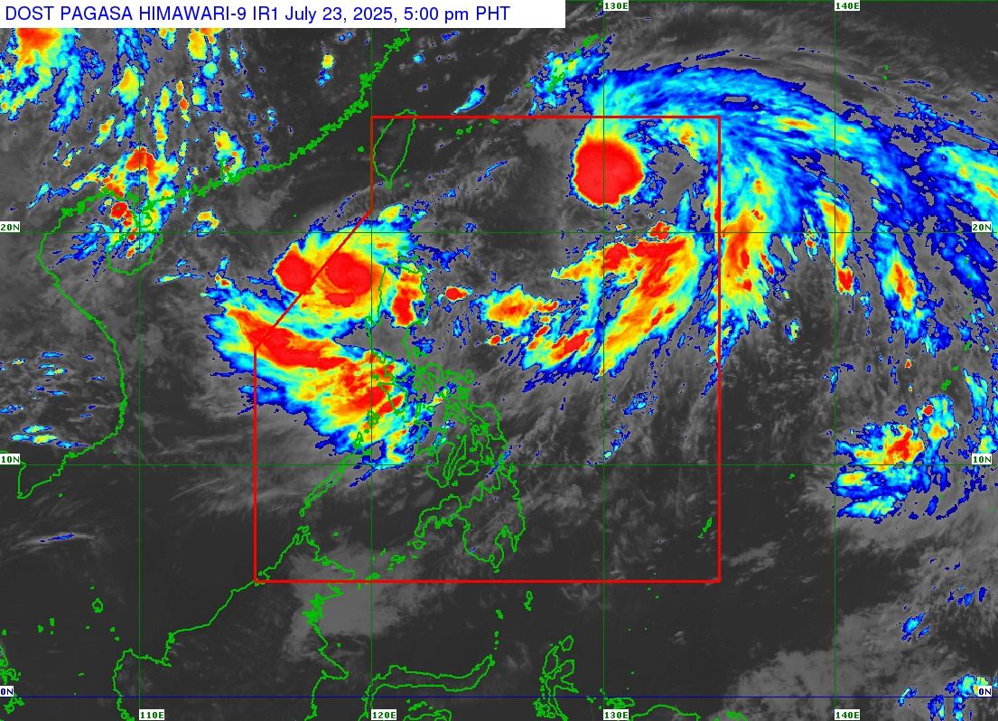
Emong, now a tropical storm, has maximum sustained winds of 65 km/h near the center and gustiness of up to 80 km/h. As of 4 p.m., Emong was located 150 km west of Laoag City, Ilocos Norte, moving southwestward at 20 km/h.
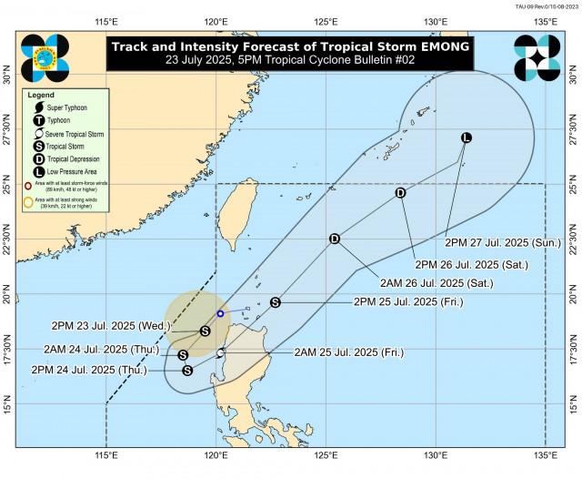
PAGASA said Emong was forecast to reach severe tropical storm category before making landfall over Ilocos Sur, La Union, or Pangasinan on Thursday evening or early Friday morning.
''This tropical cyclone will emerge over the Luzon Strait on Friday afternoon after crossing the mountainous terrain of Northern Luzon,'' PAGASA said. ''Its passage over Northern Luzon will weaken Emong into a tropical storm.''
''Emong is forecast to move generally southwestward tonight before looping over the West Philippine Sea tomorrow morning through afternoon due to its interaction with Tropical Storm Dante. Afterwards, it will move generally northeastward while accelerating,'' PAGASA added.
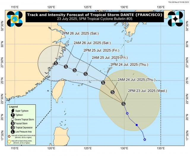
Meanwhile, Dante was last seen 835 km east northeast of Extreme Northern Luzon with maximum sustained winds of 65 km/h near the center and gustiness of up to 80 km/h.
It was moving north northwestward at 25 km/h and may slightly intensify in the next 12 hours.
''Dante is forecast to move generally northwestward over the Philippine Sea for the next 24 hours before moving west northwestward towards the Ryukyu Islands and then East China Sea. On the track forecast, Dante may exit the Philippine Area of Responsibility (PAR) tomorrow afternoon or evening,'' PAGASA said.
According to PAGASA’s daily weather forecast on Wednesday afternoon, Emong will bring rains with gusty winds over the Ilocos Region and Cordillera Administrative Region, and cloudy skies with scattered rains and thunderstorms over Cagayan Valley.
Monsoon rains will occur over Metro Manila, Zambales, Bataan, Tarlac, Pampanga, Bulacan, Cavite, Laguna, Batangas, Rizal, and Occidental Mindoro, and occasional rains over Western Visayas, Nueva Ecija, Aurora, Quezon, and the rest of MIMAROPA.
The Southwest Monsoon (Habagat) will also bring cloudy skies with scattered rains and thunderstorms over the Bicol Region and the rest of Visayas, and partly cloudy to cloudy skies with isolated rain showers or thunderstorms over Mindanao.
Flash floods or landslides may occur due to bad weather.
Moderate to strong winds with moderate to rough waters may be expected over Central, Southern, and Northern Luzon.
Visayas and Mindanao will have moderate winds with moderate coastal waters.
Classes at all levels and government work in Metro Manila and 35 provinces on Thursday were suspended due to the inclement weather. —with Jiselle Anne Casucian/VBL, GMA Integrated News
