

Signal No. 4 raised over 3 Luzon areas as Emong moves slowly
State weather forecasters on Thursday afternoon raised Tropical Cyclone Wind Signal No. 4 over three areas in Luzon as the slow-moving Typhoon Emong maintained its strength.
PAGASA's 5 p.m. tropical cyclone bulletin said winds exceeding 118 km/h up to 184 km/h may be expected in the following areas in at least 12 hours:
- the southwestern portion of Ilocos Sur (Santa Lucia, Santa Cruz, Tagudin)
- the northwestern portion of La Union (Bangar, Luna, Balaoan, Bacnotan, San Juan, City of San Fernando, Bauang)
- the extreme northwestern portion of Pangasinan (Agno, Bani, Bolinao, Anda, City of Alaminos)
Under Signal No. 3 are the following:
- the rest of Ilocos Sur
- the rest of La Union
- the northern and western portions of Pangasinan (Burgos, Dasol, Mabini, Lingayen, Bugallon, Infanta, Labrador, Sual, Dagupan City, San Fabian, Binmaley)
- the southern portion of Abra (San Quintin, Langiden, Manabo, Pidigan, Luba, Tubo, Villaviciosa, Pilar, Peñarrubia, San Isidro, Bangued, Danglas, La Paz, Tayum, Boliney, Sallapadan, Bucloc, Bucay, Dolores, Lagangilang, Licuan-Baay, Daguioman)
- the western portion of Mountain Province (Besao, Tadian, Sagada, Bauko)
- the western portion of Benguet (Sablan, Kapangan, Mankayan, Tuba, Bakun, Kibungan)
Signal No. 2 was hoisted over these areas:
- Ilocos Norte
- the rest of Pangasinan
- the rest of Abra
- Apayao
- Kalinga
- the rest of Mountain Province
- Ifugao
- the rest of Benguet
- Babuyan Islands
- the northern and western portions of mainland Cagayan (Rizal, Santa Praxedes, Claveria, Sanchez-Mira, Pamplona, Abulug, Ballesteros, Aparri, Camalaniugan, Allacapan, Buguey, Santa Teresita, Santa Ana, Gonzaga, Lal-Lo, Lasam, Santo Niño, Piat, Tuao)
- the western portion of Nueva Vizcaya (Kayapa, Santa Fe, Ambaguio, Aritao, Bambang, Bayombong, Villaverde, Solano, Bagabag)
- the northern portion of Zambales (Masinloc, Candelaria, Santa Cruz, Palauig, Iba)
Under Signal No. 1 are the following:
- Batanes
- the rest of Cagayan
- the western and central portions of Isabela (Santo Tomas, Delfin Albano, Quezon, Mallig, Quirino, Roxas, San Manuel, Aurora, San Mateo, Ramon, Cordon, Burgos, Cabatuan, Cabagan, San Pablo, Santa Maria, Tumauini, Gamu, Luna, Maconacon, Alicia, San Mariano, Naguilian, San Guillermo, City of Cauayan, Echague, Ilagan City, Angadanan, Benito Soliven, City of Santiago, Reina Mercedes, San Agustin, Divilacan, San Isidro, Jones)
- Quirino
- the rest of Nueva Vizcaya
- the rest of Zambales
- Tarlac
- the northern portion of Pampanga (Porac, Floridablanca, Angeles City, Mabalacat City, Magalang)
- the western and central portions of Nueva Ecija (Carranglan, Lupao, Talugtug, Cuyapo, Nampicuan, Guimba, Science City of Muñoz, San Jose City, Pantabangan, Rizal, Llanera, Talavera, Santo Domingo, Quezon, Licab, Aliaga, Zaragoza, San Antonio, Jaen, Cabanatuan City, Santa Rosa, General Mamerto Natividad, Palayan City, Bongabon, Laur)
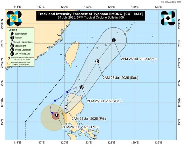
At 4 p.m. Emong was spotted over the coastal waters of Burgos, Pangasinan, carrying maximum sustained winds of 120 km/h near the center and gustiness of up to 150 km/h.
It was moving east southeastward slowly.
''Emong is currently slow-moving to almost stationary and is starting to turn more eastward towards the coastal waters of Pangasinan. The typhoon is then forecast to accelerate northeastward tonight and to make landfall or pass very close to northwestern Pangasinan tonight,'' PAGASA said.
''The typhoon may also make landfall in La Union or Ilocos Sur this late evening or tomorrow early morning. It will then cross the mountainous terrain of Northern Luzon and emerge over the Babuyan Channel tomorrow morning or noon. Afterwards, Emong will move northeastward and pass close or over Babuyan Islands between tomorrow noon and afternoon. It may also be passing near Batanes between tomorrow afternoon or evening,'' it added.
Emong may intensify further but slight weakening prior to landfall due to increasing interaction with the terrain of northwestern Luzon has not been ruled out.
Classes at all levels and government work in Metro Manila and several provinces on Friday, July 25, 2025, have been suspended due to projected heavy rains from Emong and the Southwest Monsoon (Habagat).
According to PAGASA's daily weather forecast, the Ilocos Region, Cordillera Administrative Region, Batanes, and Cagayan will have stormy conditions, while rains with gusty winds will prevail over the rest of Cagayan Valley, Zambales, Tarlac, and Nueva Ecija due to Emong.
The Southwest Monsoon will affect the rest of the country.
Winds be strong and coastal waters will be rough in the western section of Southern Luzon.
Moderate to strong winds and moderate to rough coastal waters are expected in the rest of Central and Southern Luzon and the western section of Visayas.
The rest of the country will experience moderate winds and coastal waters. —Jiselle Anne Casucian/VBL, GMA Integrated News
