

Signal No. 3 hoisted over 3 areas as Emong to pass Batanes, Babuyan Islands
Tropical Cyclone Wind Signal (TCWS) No. 3 is in effect over parts of Ilocos Norte, Apayao, and Cagayan as Severe Tropical Storm Emong is expected to pass close or over Batanes and Babuyan Islands from Friday afternoon to evening.
In its 11 a.m. bulletin on Friday, state weather bureau PAGASA said the following areas are under TCWS No. 3:
- northeastern portion of Ilocos Norte (Bangui, Pagudpud, Dumalneg, Piddig, Vintar, Adams, Carasi)
- northern portion of Apayao (Calanasan, Luna)
- northwestern portion of mainland Cagayan (Santa Praxedes, Claveria, Sanchez-Mira, Pamplona)
TCWS No. 2 is raised over the following areas:
- the rest of Ilocos Norte
- northern portion of Ilocos Sur (Santa, Caoayan, City of Vigan, Bantay, Santa Catalina, San Vicente, Santo Domingo, San Ildefonso, Magsingal, San Juan, Cabugao, Sinait)
- the rest of Apayao
- northern portion of Abra (Pidigan, San Juan, Tayum, Langiden, Sallapadan, Lagangilang, Danglas, La Paz, Licuan-Baay, Tineg, Malibcong, Peñarrubia, San Isidro, San Quintin, Dolores, Lagayan, Bangued, Bucay, Lacub)
- Batanes
- northern and western portion of mainland Cagayan (Piat, Camalaniugan, Tuao, Buguey, Aparri, Allacapan, Rizal, Lasam, Ballesteros, Abulug, Santo Niño)
Meanwhile, TCWS No. 1 is hoisted over the following areas:
- the rest of Ilocos Sur
- northern portion of La Union (Luna, Santol, City of San Fernando, San Juan, Bagulin, Bangar, San Gabriel, Bacnotan, Sudipen, Balaoan)
- the rest of Abra
- northern portion of Benguet (Mankayan, Kapangan, Atok, Kabayan, Kibungan, Bakun, Buguias)
- Kalinga
- Mountain Province
- Ifugao
- the rest of mainland Cagayan
- northern portion of Isabela (Quirino, Mallig, Quezon, Delfin Albano, Tumauini, Maconacon, San Pablo, Santa Maria, Cabagan, Santo Tomas, Roxas, San Manuel)
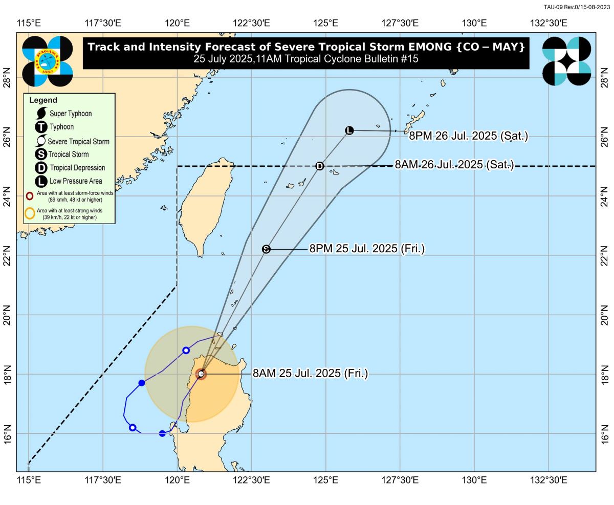
Emong was last located in the vicinity of Calanasan, Apayao with maximum sustained winds of 95 kph near the center and gusts of up to 160 kph.
It was moving north northeastward at 40 kph.
"EMONG is about to emerge over the Babuyan Channel. On the track forecast, it will pass close or over Babuyan Islands and Batanes from this afternoon to early evening while accelerating north northeastward," PAGASA said.
It is expected to exit the Philippine Area of Responsibility (PAR) Saturday morning.
"EMONG will continue to weaken throughout the forecast period due to increasing unfavorable environment. It will likely degenerate into a remnant low tomorrow evening while entering the East China Sea. However, a slightly faster weakening trend is not ruled out," PAGASA said.
Reported deaths
Many parts of the country have been battered by heavy rains and floods over the past days due to the onslaught of Tropical Cyclones Crising, Dante, Emong, and the Southwest Monsoon or Habagat.
In its 6 a.m. report on Friday, the National Disaster Risk Reduction and Management Council (NDRRMC) said the reported death toll due to these weather disturbances has climbed to 25.
Of this number, nine were reported in Metro Manila, and three each in Calabarzon, Western Visayas, Negros Island Region, and Northern Mindanao. One death each was reported in Central Luzon, Mimaropa, Davao Region, and Caraga.
The NDRRMC has confirmed three of the reported deaths.
A total of 3,849,624 people or 1,065,779 families have been affected by the bad weather in all regions except Eastern Visayas.
Of the total affected population, 167,257 people or 47,522 families were staying in evacuation centers, while 111,454 people or 27,685 families were taking shelter in other places.
A state of calamity has been declared in 84 cities and municipalities. — VDV, GMA Integrated News
