

Nando moves away from Babuyan Islands after making landfall over Panuitan
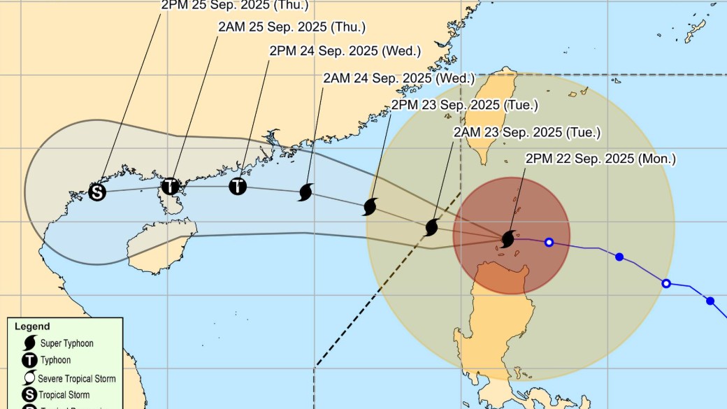
Super Typhoon Nando is moving away from the Babuyan Islands after making landfall earlier over Panuitan Island in Calayan, Cagayan, state weather bureau PAGASA said Monday.
As of 4 p.m., the center of the super typhoon was located over the coastal waters of Calayan Island in Calayan, Cagayan. It is moving westward at 25 kilometers per hour.
Nando maintained its strength with maximum sustained winds of 215 kph near the center, and gustiness of up to 295 kph.
Tropical Cyclone Wind Signal (TWCS) No. 5 remains hoisted over Babuyan Islands.
Further, the following TWCS are hoisted over these areas:Signal No. 4
- The southern portion of Batanes (Basco, Mahatao, Ivana, Uyugan, Sabtang)
- The northern portion of mainland Cagayan (Santa Ana, Santa Praxedes, Claveria, Sanchez-Mira, Pamplona, Abulug, Ballesteros, Aparri, Buguey, Santa Teresita, Gonzaga, Camalaniugan)
- The northern portion of Ilocos Norte (Pagudpud, Burgos, Bangui, Dumalneg, Adams)
Signal No. 3
- The rest of Batanes, the central portion of mainland Cagayan (Lal-Lo, Gattaran, Baggao, Alcala, Santo Niño, Lasam, Allacapan, Rizal, Amulung, Piat)
- The northern and central portions of Apayao (Flora, Santa Marcela, Pudtol, Luna, Calanasan, Kabugao)
- The rest of Ilocos Norte
Signal No. 2
- The rest of mainland Cagayan
- Isabela
- The rest of Apayao
- Abra
- Kalinga
- Mountain Province
- Ifugao
- The northern portion of Benguet (Mankayan, Buguias, Bakun, Kibungan)
- The northeastern portion of Nueva Vizcaya (Diadi)
- Ilocos Sur
- The northern portion of La Union (Sudipen, Bangar, Luna, Balaoan, Santol)
Signal No. 1
- Quirino
- The rest of Nueva Vizcaya
- The rest of Benguet
- The rest of La Union
- Pangasinan
- Aurora
- Nueva Ecija
- Bulacan
- Tarlac
- Pampanga
- Zambales
- The northern portion of Quezon (General Nakar) including Polillo Islands
PAGASA said Nando will move away from the Babuyan Islands on Monday evening and will exit the Philippine Area of Responsibility on Tuesday morning, September 23.
“NANDO is at its peak intensity, although slight intensification is still not ruled out. Nevertheless, the super typhoon is forecast to begin weakening within the next 24 hours due to marginally favorable environment that it will encounter over the West Philippine Sea,” the state weather bureau said.Further, PAGASA said in its heavy rainfall outlook that Nando may bring more than 200 millimeters of rainfall over Ilocos Norte, Ilocos Sur, La Union, and Benguet until Tuesday afternoon.
The super typhoon may also bring 50 to 100 mm of rain over Batanes, Cagayan, Apayao, and Abra. Meanwhile, 50 to 100 mm of rain may be experienced at Pangasinan and Zambales until Tuesday afternoon. —Vince Angelo Ferreras/RF, GMA Integrated News
