

3 Luzon areas remain under Signal No. 3 as Nando weakens
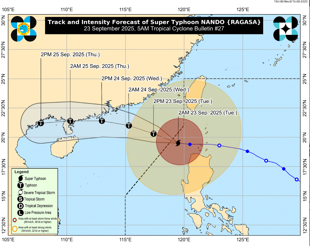
Super Typhoon Nando continues to weaken as it heads to exit the Philippine Area of Responsibility on Tuesday, according to the forecast of PAGASA.
Still, three areas remain under Signal No. 3:
- Ilocos Norte
- the northwestern portion of Apayao (Calanasan)
- the northwestern portion of mainland Cagayan (Sanchez-Mira, Santa Praxedes, Claveria) including the western portion of Babuyan Islands (Panuitan Isl., Calayan Isl., Dalupiri Isl., Mabaag Isl., Barit Isl., Fuga Isl.)
Under Signal No. 2 are the following:
- Batanes
- the rest of Babuyan Islands
- the northern and central portions of Cagayan (Iguig, Solana, Tuao, Baggao, Amulung, Piat, Santa Ana, Gattaran, Lal-Lo, Gonzaga, Pamplona, Abulug, Ballesteros, Aparri, Camalaniugan, Buguey, Santa Teresita, Allacapan, Lasam, Santo Niño, Alcala, Rizal)
- the rest of Apayao
- Abra
- Kalinga
- the western portion of Mountain Province (Besao, Tadian, Sagada, Bauko, Sadanga, Bontoc, Sabangan)
- the northern portion of Benguet (Mankayan, Bakun)
- Ilocos Sur
- the northern portion of La Union (Sudipen, Bangar, Luna, Balaoan, Santol)
Under Signal No. 1 are the following:
- the rest of Cagayan
- Isabela
- Quirino
- Nueva Vizcaya
- the northern and central portions of Aurora (Dilasag, Casiguran, Dinalungan, Dipaculao, Maria Aurora)
- the rest of Mountain Province
- Ifugao
- the rest of Benguet
- the rest of La Union
- Pangasinan
- the northern portion of Zambales (Santa Cruz, Candelaria, Masinloc, Iba, Palauig)
- the northern and central portions of Tarlac (Paniqui, La Paz, Moncada, City of Tarlac, San Jose, Gerona, Mayantoc, Pura, San Clemente, Santa Ignacia, Victoria, Camiling, Ramos, San Manuel, Anao)
- the northern and central portions of Nueva Ecija (Cuyapo, Talavera, Santo Domingo, Rizal, Zaragoza, Llanera, Guimba, Aliaga, Pantabangan, Science City of Muñoz, General Mamerto Natividad, Carranglan, Quezon, San Jose City, Lupao, Nampicuan, Talugtug, Licab, Bongabon)
The center of the eye of Nando was estimated at 265 kilometers west of Calayan, Cagayan. It is moving westward at 20 km/h with maximum sustained winds of 185 km/h near the center and gustiness of up to 230 km/h.
PAGASA said Nando is forecast to move generally west northwestward until it exits PAR Tuesday morning. Afterwards, it will turn westward on September 24 towards southern China.
Meanwhile, PAGASA said it has monitored another low pressure area outside PAR, which has a "high" potential of developing into a tropical depression within the next 24 hours.
For the daily weather forecast, areas under tropical cyclone wind signal are expected to experience heavy with at times intense rains.
Zambales, Tarlac, and Nueva Ecija will have cloudy skies with scattered rains and thunderstorms also as a result of the super typhoon.
Metro Manila, MIMAROPA, CALABARZON, and the rest of Central Luzon will have cloudy skies with scattered rains and thunderstorms due to the Southwest Monsoon.
The rest of the country will see partly cloudy to cloudy skies with isolated rainshowers or thunderstorms also due to the Southwest Monsoon.
Sunrise is at 5:45 a.m. and sunset is at 5:52 p.m. —LDF, GMA Integrated News
