

Paolo intensifies as it moves closer to Aurora, Isabela
Severe Tropical Storm Paolo further intensified as it moved closer to Northern Aurora and Southern Isabela on Friday morning.
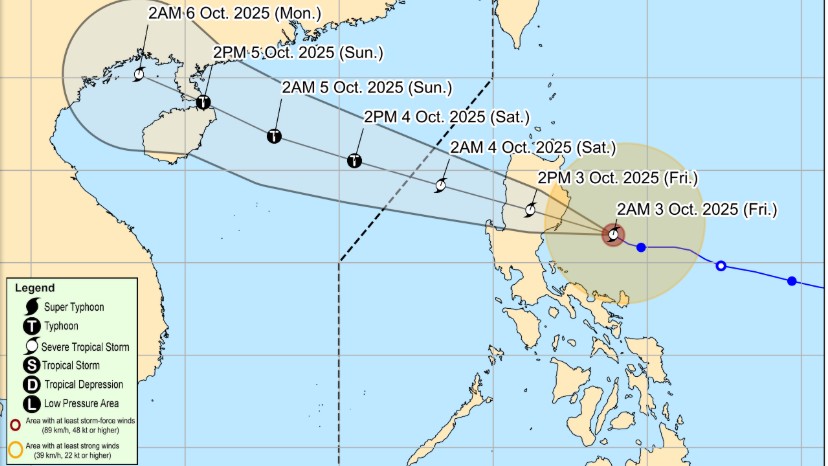
In its 5 a.m. tropical cyclone advisory, PAGASA said Paolo is expected to make landfall between the two provinces on the morning of October 3, 2025.
“The center of Severe Tropical Storm PAOLO was estimated based on all available data including those from Baler and Daet Doppler Weather Radar 150 km East of Casiguran, Aurora (16.0 °N, 123.5 °E ),” the agency said.
Paolo was moving West Northwestward at 20 km/h. It has maximum sustained winds of 100 km/h near the center and gustiness of up to 125 km/h.
Signal No. 3 is in effect over the following areas:
Luzon:- The northern portion of Aurora (Dilasag, Casiguran, Dinalungan),
- the central and southern portions of Isabela (Dinapigue, San Mariano, San Guillermo, Echague, Jones, San Agustin, Cordon, City of Santiago, Ramon, San Isidro, Alicia, Angadanan, City of Cauayan, Benito Soliven, Naguilian, Luna, Reina Mercedes, Cabatuan, San Mateo, Aurora, San Manuel, Burgos, Gamu, Roxas, Palanan),
- the northern portion of Quirino (Maddela, Cabarroguis, Aglipay, Saguday, Diffun),
- the northern portion of Nueva Vizcaya (Diadi, Bagabag, Villaverde, Ambaguio, Quezon, Solano, Bayombong),
- Mountain Province,
- Ifugao,
- the southeastern portion of Abra (Tubo),
- the northern portion of Benguet (Mankayan, Buguias, Kabayan, Bakun, Kibungan, Atok, Kapangan),
- the central and southern portions of Ilocos Sur (Sugpon, Alilem, Cervantes, Suyo, Tagudin, Santa Cruz, Sigay, Quirino, Gregorio del Pilar, Salcedo, Santa Lucia, City of Candon, San Emilio, Galimuyod, Lidlidda, Banayoyo, Santiago, San Esteban, Burgos),
- and the northern portion of La Union (Sudipen, Santol, Balaoan, Luna, Bangar, San Gabriel, Bacnotan, San Juan)
Signal No.2 has been hoisted over:
Luzon:
- The central and southern portions of mainland Cagayan (Peñablanca, Tuguegarao City, Enrile, Solana, Iguig, Tuao, Piat, Rizal, Santo Niño, Alcala, Amulung),
- the rest of Isabela,
- the rest of Quirino,
- the rest of Nueva Vizcaya,
- the central portion of Aurora (Dipaculao, Baler, Maria Aurora, San Luis),
- the northern portion of Nueva Ecija (Carranglan, Bongabon, San Jose City, Pantabangan, Rizal, Lupao),
- the central and southern portions of Apayao (Conner, Kabugao),
- Kalinga,
- the rest of Abra,
- the rest of Benguet,
- the central and southern portions of Ilocos Norte (Nueva Era, Badoc, Pinili, City of Batac, Paoay, Currimao, Banna, Laoag City, San Nicolas, Sarrat, Dingras, Solsona, Marcos, Bacarra, Piddig), the rest of Ilocos Sur,
- the rest of La Union,
- and the northern portion of Pangasinan (San Fabian, Sison, Pozorrubio, Umingan, San Jacinto, Laoac, Binalonan, San Nicolas, Natividad, Tayug, San Manuel, Asingan, Santa Maria, San Quintin, Dagupan City, Mangaldan, Manaoag, Bolinao, Anda, Bani, City of Alaminos, Sual, Labrador, Lingayen, Binmaley, Calasiao, Mapandan, Santa Barbara, City of Urdaneta)
Here are the locations under Signal No.1:
Luzon:- The rest of mainland Cagayan including Babuyan Islands,
- the rest of Aurora,
- the northern portion of Quezon (General Nakar, Infanta) including Polillo Islands,
- Camarines Norte,
- the northern portion of Camarines Sur (Siruma, Tinambac, Lagonoy, Garchitorena, Caramoan, Goa, San Jose, Presentacion),
- Catanduanes,
- the rest of Apayao,
- the rest of Ilocos Norte,
- the rest of Pangasinan,
- the rest of Nueva Ecija,
- the northern portion of Bulacan (Doña Remedios Trinidad, San Miguel, San Ildefonso, Norzagaray, San Rafael),
- Tarlac,
- the northeastern portion of Pampanga (Magalang, Arayat, Candaba, Mabalacat City),
- and the northern portion of Zambales (Palauig, Masinloc, Candelaria, Santa Cruz)
“PAOLO is forecast to move generally west northwestward throughout the forecast period. On the forecast track, PAOLO may make landfall in northern Aurora or southern Isabela this morning or noon. Further southward shift of track is possible depending on the strength of the high pressure area located north of PAOLO," the state weather bureau said.
After crossing the landmass of Northern Luzon, it will emerge over the West Philippine Sea this afternoon or evening and will continue moving west northwestward until it exits the Philippine Area of Responsibility tomorrow (04 October) morning,” it added.
The storm will continue to intensify over the Philippine Sea and that it is “highly likely” Paolo can become a typhoon once it emerges into the West Philippine Sea. —RF, GMA Integrated News
