

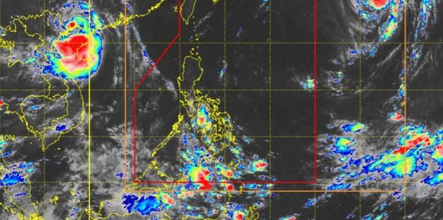
ITCZ to bring rains over parts of Mindanao; Halong being monitored
An Intertropical Convergence Zone (ITCZ) affecting Southern Mindanao will bring rains over some areas on Monday, PAGASA said in its weather forecast.
Zamboanga Peninsula and BARMM will have cloudy skies with scattered rains and thunderstorms due to the ITCZ or belt where the winds from the northern and southern hemisphere meet.
Moderate to at times heavy rains may possibly result in flash floods or landslides.
Meanwhile, Metro Manila and the rest of the country will have generally fair weather, with partly cloudy to cloudy skies and isolated rain showers or thunderstorms due to localized thunderstorms. During severe thunderstorms, flash floods or landslides may occur.
Coastal waters will be slight to moderate throughout the country.
Sunrise was at 5:46 a.m. while sunset will be at 5:42 p.m.
PAGASA is also monitoring Severe Tropical Storm Halong which is located outside the Philippine Area of Responsibility (PAR).
At 3 a.m., Halong was estimated to be located at 2,105 km east northeast of Extreme Northern Luzon, packing maximum sustained winds of 100 km/h near the center and with gustiness of up to 125 km/h.
Halong is moving northwestward slowly.
"Less likely ito na pumasok ng ating Philippine Area of Responsibility... pero in the event na pumasok man ito ng PAR, ang ibibigay nating local name para sa bagyong ito ay Quedan," PAGASA weather specialist Daniel James Villamil said in a public weather forecast.
(It is less likely to enter our Philippine Area of Responsibility. However, in the event that it enters PAR, the local name we will give it is Quedan.)
If Halong enters PAR, it will just be in the northern boundary of PAR, he added.
Halong will have no effect on weather and sea conditions, and its center will be far from the country in the next few days, Villamil said. —KG, GMA Integrated News
