

Ramil moves closer to Northeastern Luzon, Signal No.1 raised over 6 areas
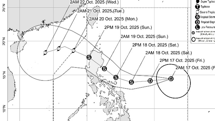
Tropical Depression Ramil continued to move closer to Eastern Luzon with landfall expected on the morning of Sunday, October 19.
According to its 5 a.m. Tropical Cyclone Bulletin on Friday, PAGASA said the center of Ramil was estimated at 1,145 km. east of Southeastern Luzon (14.4°N, 132.3°E).
Signal No. has been raised over the following areas:
- The easternmost portion of Quezon (Tagkawayan)
- Camarines Norte
- Catanduanes
- Camarines Sur
- Albay
- The northern and eastern portions of Sorsogon (Donsol, Pilar, Castilla, City of Sorsogon, Gubat, Prieto Diaz, Casiguran, Barcelona, Bulusan)
The storm has maximum sustained winds of 45 km/h near the center, gustiness of up to 55 km/h, and central pressure of 1004 hPa.
The state weather bureau said Ramil's present movement is "west northwest slowly".
As to its strength, Ramil has strong winds extending outwards up to 350 km from its center.
Earlier, PAGASA said Ramil and the Easterlies are expected to cast gray skies with rains over several parts of Luzon and the Visayas.
Ramil's trough will bring cloudy skies with scattered rains and thunderstorms over Catanduanes, Albay, Sorsogon, Northern Samar, and Eastern Samar.
Meanwhile, the Easterlies are affecting Central Luzon, Southern Luzon, and Visayas. These will experience cloudy skies with scattered rains and thunderstorms.
Affected areas include Metro Manila, CALABARZON, mainland Cagayan, Isabela, Bulacan, Aurora, Oriental Mindoro, Marinduque, Romblon, the rest of Bicol Region, and the rest of Visayas.
Based on its 12-hour forecast, the center of the storm is expected to be 565 km east of Virac, Catanduanes at 2 p.m. this Friday. —RF, GMA Integrated News
